Lyngseidet
| Lyngseidet | |
|---|---|
| Village | |
|
View of the village | |
 Lyngseidet  Lyngseidet Location in Troms | |
| Coordinates: 69°34′34″N 20°13′07″E / 69.57611°N 20.21861°ECoordinates: 69°34′34″N 20°13′07″E / 69.57611°N 20.21861°E | |
| Country | Norway |
| Region | Northern Norway |
| County | Troms |
| District | Nord-Troms |
| Municipality | Lyngen |
| Area[1] | |
| • Total | 0.84 km2 (0.32 sq mi) |
| Elevation[2] | 5 m (16 ft) |
| Population (2013)[1] | |
| • Total | 815 |
| • Density | 970/km2 (2,500/sq mi) |
| Time zone | CET (UTC+01:00) |
| • Summer (DST) | CEST (UTC+02:00) |
| Post Code | 9060 Lyngseidet |
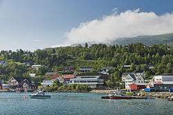
Lyngseidet (also Northern Sami: Ivgumuotki, Kven: Yykeänmuotka) is the administrative centre of the municipality of Lyngen in Troms county, Norway. The village is located on an isthmus that is about 3 km (1.9 mi) wide between an arm of the Ullsfjorden and the Lyngenfjorden.
The village is home to a grocery store, Lyngen Church, nursing home, schools, daycare, and library. The plastic Santa Claus named Gollis is also located here. Lyngseidet is located 15 km (9.3 mi) north of the village of Furuflaten and 12 km (7.5 mi) by ferry from Olderdalen, in Kåfjord. The 0.84-square-kilometre (210-acre) village has a population (2013) of 815, which gives the village a population density of 970 inhabitants per square kilometre (2,500/sq mi).[1]
References
- 1 2 3 Statistisk sentralbyrå (1 January 2013). "Urban settlements. Population and area, by municipality.".
- ↑ "Lyngseidet" (in Norwegian). yr.no. Retrieved 2012-12-17.