Lyneham, Australian Capital Territory
| Lyneham Canberra, Australian Capital Territory | |||||||||||||
|---|---|---|---|---|---|---|---|---|---|---|---|---|---|
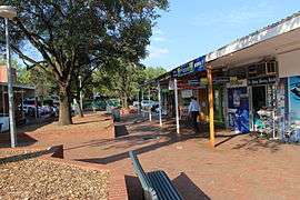 Lyneham shops | |||||||||||||
 | |||||||||||||
| Coordinates | 35°15′0″S 149°07′45″E / 35.25000°S 149.12917°ECoordinates: 35°15′0″S 149°07′45″E / 35.25000°S 149.12917°E | ||||||||||||
| Population | 4,484 (2011 census)[1] | ||||||||||||
| • Density | 815/km2 (2,112/sq mi) | ||||||||||||
| Established | 1928 | ||||||||||||
| Postcode(s) | 2602 | ||||||||||||
| Area | 5.5 km2 (2.1 sq mi) | ||||||||||||
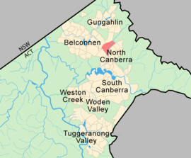
| District | North Canberra | ||||||||||||
| Territory electorate(s) | Kurrajong | ||||||||||||
| Federal Division(s) | Fenner[2] | ||||||||||||
| |||||||||||||
Lyneham is a suburb of Canberra, Australia in the North Canberra district. It is named after Sir William Lyne, premier of the Australian state of New South Wales from 1899 to 1901. The suburb name was gazetted in 1928, but development did not commence until 1958. The streets of Lyneham are named after artists and people associated with the development of early Canberra.[3]
Points of interest

Lyneham has many attractions including nature parks and bushland, proximity to the centre of Canberra, popular cafes including the famous Tilley's Devine Cafe and Gallery as well as the Front Cafe and Gallery, and a number of sporting facilities including the National Hockey Centre, Canberra Racecourse and the ACT Netball Centre.
Also located in Lyneham is Exhibition Park in Canberra (EPIC), which annually hosts Australia's best known car festival, Summernats, the Royal Canberra Show and the National Folk Festival.
St Ninian's Uniting Church in Brigalow Street is the second-oldest church in Canberra, opened in 1873. It was founded as a Presbyterian Church by the Scottish community, many of whom had come to the area as shepherds.[4] It has been heritage-listed by the ACT Heritage Council.[5]
Character
The style of the suburb has been evolving since development commenced in 1958 at the north-western periphery of what is now 'inner' Canberra. The older homes built in 1958-59 (many of which catered to the sizeable influx of Commonwealth Public Servants' families, who were being relocated with their respective Departments' headquarters from Melbourne), now sit beside modern townhouse developments, while individual blocks are being 'gentrified' by either extensive renovation or demolition and rebuilt homes. Having mainly been substantially established since the 1960s, Lyneham residents enjoy its leafy streets and established gardens. A scenic wetland was built adjacent to Sullivans Creek in Lyneham to improve downstream water quality. It was opened to the public in April 2012 and it is frequented by wood ducks.[6]
Many of the single houses between Sullivans Creek and Northbourne Avenue have been replaced by two and three storey flats in recent years.[7] Land adjoining Northbourne Avenue is now zoned to permit redevelopment with 25 metre (about 8 storeys) high flats or 32 metres (about 11 storeys) at the corners of Mouat Street and Macarthur Avenue with Northbourne Avenue[8] and the first such flats were completed on the site of a two-storey motel on the corner of Northbourne Ave and Mouat St in 2013.
North Lyneham
The residential part of Lyneham built to the north of Ginninderra Drive having been developed in the mid to late 1980s was a relatively recent addition to the original suburban homes of 1960s' Lyneham. The original residences on "old" Lyneham, contained within the area bounded by Wattle, Dyandra, Archibald and Mouat Streets and Northbourne Avenue mainly date back to the late 1950s. North Lyneham's main feeder road, Cossington Smith Crescent, loops through the area with other streets coming off it. North Lyneham also has a small shopping centre housing shops, a couple of restaurants and a number of small businesses. North Lyneham backs onto a bush reserve which separates it from the Belconnnen suburb of Kaleen. The walking trails in the reserve are popular with the local residents and provide scenic views of the inner northern suburbs of Canberra to the east and south and Belconnen and the Brindabella Ranges to the west.
 The Pines, townshouses built in the 1980s |
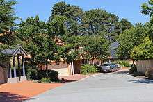 Town houses in the Sanctuary, north Lyneham |
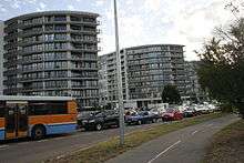 First high-rise flats in Mouat St |
 New flats next to wetland |
Demographics
In the 2011 Census, the population of Lyneham was 4,484, including 35 (0.8%) Indigenous persons and 2,877 (64.1%) Australian-born persons. Only 36.5% of dwellings were separate houses (compared to the Australian average of 75.6%), while 39.4% were semi-detached, row or terrace houses (Australian average: 9.9%) and 24.0% were flats, units or apartments (Australian average: 13.6%). 41.5% of the population were professionals, compared to the Australian average of 21.3%. Notably 20.8% worked in government administration, compared to the Australian average of 1.3%, although the Canberra-wide average is a very similar 20.1%. Lyneham is favoured by students and young adults with 32.8% of its population in the 20- to 34-year-old age group (compared to the Australian average of 20.6%). The suburb has few children under 15: 10.8%, compared to 19.3% Australia-wide. 35.5% of the dwellings are occupied by single person households, compared to the Australian average of 24.3%. 36.5% of the population had no religion, while 18.8% were Catholic and 10.7% were Anglican.[1]
Politics
| ||||||||||||||||||||||||||||||||||||
Lyneham is located within the federal electorate of Fenner and it is represented by Andrew Leigh for the Labor Party. In the ACT Legislative Assembly, Lyneham is part of the electorate of Kurrajong, which elects five members on the basis of proportional representation, two Labor, two Liberal and one Greens.[11] Polling place statistics are shown to the right for the Lyneham polling place at Lyneham Primary School in the 2016 federal[9] and 2016 ACT[10] elections.
Education
Lyneham is home to Lyneham High School,[12] Lyneham Primary School[13] and Brindabella Christian College.[14]
Geology
Silurian calcareous shales from the Canberra Formation is overlain by Quaternary alluvium. This rock is the limestone of the original title of Canberra "Limestone Plains". Greywacke from the Ordovician age Pittman Formation is in the north west.[15]
Notes
- 1 2 Australian Bureau of Statistics (31 October 2012). "Lyneham (State Suburb)". 2011 Census QuickStats. Retrieved 27 December 2013.
- ↑ "Profile of the electoral division of Fenner (ACT)". Current federal electoral divisions. Australian Electoral Commission. 8 February 2016. Retrieved 29 May 2016.
- ↑ "Suburb Name search results". ACT Planning & Land Authority. Retrieved 28 December 2013.
- ↑ "A Brief History of the Church". St Ninian's Uniting Church. Retrieved 24 October 2006.
- ↑ "Heritage (Decision about Registration for St Ninian's Church – nineteenth century elements, Lyneham). Notice 2011" (PDF). ACT Heritage Council. Retrieved 11 March 2014.
- ↑ "Dickson and Lyneham Wetlands". ACT Environment and Sustainable Development Directorate. Retrieved 24 February 2014.
- ↑ "Inner North Precinct Code" (PDF). ACT Planning and Land Authority. 29 November 2013. Retrieved 24 February 2014.
- ↑ "Northbourne Avenue Precinct Code" (PDF). ACT Planning and Land Authority. 18 December 2012. Retrieved 23 February 2014.
- 1 2 "Federal Election 2016 - Polling Place Lyneham". Australian Electoral Commission. 15 July 2016. Retrieved 12 November 2016.
- 1 2 "2016 Results for Kurrajong Candidates at Lyneham Polling Place". ACT Electoral Commission. 12 November 2016. Retrieved 12 November 2016.
- ↑ "Current members". ACT Legislative Assembly. Retrieved 12 November 2016.
- ↑ Lyneham High School
- ↑ Lyneham Primary School
- ↑ Brindabella Christian College
- ↑ Henderson G A M and Matveev G, Geology of Canberra, Queanbeyan and Environs 1:50000 1980.
External links and references
| Wikimedia Commons has media related to Lyneham, Australian Capital Territory. |
- Connery, Georgina (28 March 2014). "A weekend in your suburb: 36 hours in Lyneham". The Canberra Times. Fairfax Media. Archived from the original on 3 April 2014.
- Exhibition Park in Canberra