Lyndhurst, Ohio
| Lyndhurst, Ohio | |
|---|---|
| City | |
|
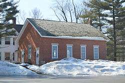
Old Euclid District 4 Schoolhouse | |
| Motto: "A Community of Neighbors" | |
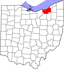
 Location in Cuyahoga County and the state of Ohio. | |
.svg.png) Location of Ohio in the United States | |
| Coordinates: 41°31′17″N 81°29′25″W / 41.52139°N 81.49028°WCoordinates: 41°31′17″N 81°29′25″W / 41.52139°N 81.49028°W | |
| Country | United States |
| State | Ohio |
| County | Cuyahoga |
| Government | |
| • Mayor | Patrick Ward |
| Area[1] | |
| • Total | 4.44 sq mi (11.50 km2) |
| • Land | 4.43 sq mi (11.47 km2) |
| • Water | 0.01 sq mi (0.03 km2) |
| Elevation[2] | 1,033 ft (315 m) |
| Population (2010)[3] | |
| • Total | 14,001 |
| • Estimate (2012[4]) | 13,821 |
| • Density | 3,160.5/sq mi (1,220.3/km2) |
| Time zone | Eastern (EST) (UTC-5) |
| • Summer (DST) | EDT (UTC-4) |
| ZIP code | 44124 |
| Area code(s) | 216, 440 |
| FIPS code | 39-45556[5] |
| GNIS feature ID | 1061453[2] |
| Website | http://www.lyndhurst-oh.com/ |
Lyndhurst is a city in Cuyahoga County, Ohio, United States, and an eastern suburb of Cleveland. The population was 14,001 at the 2010 census. A small part of Lyndhurst was originally part of Mayfield Township.
Geography
Lyndhurst is located at 41°31′17″N 81°29′25″W / 41.52139°N 81.49028°W (41.521352, -81.490141).[6] It is bordered by South Euclid (with which it shares a school district), Richmond Heights, Highland Heights, Mayfield Heights, Pepper Pike, and Beachwood.
According to the United States Census Bureau, the city has a total area of 4.44 square miles (11.50 km2), of which 4.43 square miles (11.47 km2) is land and 0.01 square miles (0.03 km2) is water.[1]
History
The land currently comprising Lyndhurst was part of the Western Reserve, obtained via treaty with the Iroquois tribe in 1796 by the Connecticut Land Company. In 1797, Moses Cleaveland named the area east of the Cuyahoga River Euclid, after the Greek Mathematician and Patron Saint of surveyors. Euclid Township was officially formed in 1809. Despite this, Lyndhurst’s population consisted mostly of Native American Indians until after the War of 1812.[7]
In 1828 Euclid Township was divided into nine districts, with the present area of Lyndhurst becoming district four.
From 1877 the main traffic corridor has been Mayfield Road (U.S. Route 322). Initially a wood-planked toll road, it is now home to many retail establishments and restaurants.
The earliest industry was farming. As the area grew, it became known as Euclidville Village, the name changing to Lyndhurst Village in 1920 before Lyndhurst was formally incorporated as a city in 1921.
Population growth in Lyndhurst, which tapered during the Great Depression, skyrocketed during the postwar period, driven by both the baby boom and white flight from the urban center of Cleveland. Lyndhurst's population peaked in the 1970s. By 1980, lacking large tracts of available land for development, and with a population shift to exurban communities, the population of Lyndhurst began to shrink. The 2010 population of Lyndhurst was 29% less than its peak during the 1970s.
Demographics
| Historical population | |||
|---|---|---|---|
| Census | Pop. | %± | |
| 1920 | 288 | — | |
| 1930 | 1,922 | 567.4% | |
| 1940 | 2,391 | 24.4% | |
| 1950 | 7,359 | 207.8% | |
| 1960 | 16,805 | 128.4% | |
| 1970 | 19,749 | 17.5% | |
| 1980 | 18,093 | −8.4% | |
| 1990 | 15,982 | −11.7% | |
| 2000 | 15,279 | −4.4% | |
| 2010 | 14,001 | −8.4% | |
| Est. 2015 | 13,691 | [8] | −2.2% |
| Sources:[9][10][5][11] | |||
The median income for a household in the city was $52,272, and the median income for a family was $64,961. Males had a median income of $45,172 versus $31,652 for females. The per capita income for the city was $28,206. About 1.3% of families and 2.5% of the population were below the poverty line, including 1.4% of those under age 18 and 3.3% of those age 65 or over.
Of the city's population over the age of 25, 43.2% held a bachelor's degree or higher.[12]
2010 census
As of the census[3] of 2010, there were 14,001 people, 6,447 households, and 3,826 families residing in the city. The population density was 3,160.5 inhabitants per square mile (1,220.3/km2). There were 6,890 housing units at an average density of 1,555.3 per square mile (600.5/km2). The racial makeup of the city was 90.3% White, 6.4% African American, 1.6% Asian, 0.4% from other races, and 1.2% from two or more races. Hispanic or Latino of any race were 1.3% of the population.
There were 6,447 households of which 21.4% had children under the age of 18 living with them, 48.2% were married couples living together, 8.4% had a female householder with no husband present, 2.8% had a male householder with no wife present, and 40.7% were non-families. 35.5% of all households were made up of individuals and 17.3% had someone living alone who was 65 years of age or older. The average household size was 2.15 and the average family size was 2.80.
The median age in the city was 47 years. 17.4% of residents were under the age of 18; 5.2% were between the ages of 18 and 24; 25% were from 25 to 44; 28.1% were from 45 to 64; and 24.3% were 65 years of age or older. The gender makeup of the city was 46.0% male and 54.0% female.
Education
The South Euclid-Lyndhurst City School District consists of:
- 3 elementary schools: Adrian, Rowland, and Sunview
- 1 upper elementary school (grades 4–6): Greenview
- 1 junior high school (Grades 7–8): Memorial
- 1 high school, Charles F. Brush
Events and attractions
Eggshelland is an annual lawn display of Easter egg mosaics, originally located at a resident's home between 1957 and 2013,[13][14][15][16] during which time it became the subject of a documentary film.[15][17] A different party took ownership of the maintenance of Eggshelland in 2014.[18]
Notable people
- Eric Carmen - singer, songwriter, and musician; lead singer, the Raspberries
- Josh Mandel - Ohio State Treasurer
- The Poni-Tails - 1950s girl group
- Mike Trivisonno - radio broadcaster, WTAM
- Steven Hirsch - founder, Vivid Entertainment
Surrounding communities
 |
Euclid | Richmond Heights, Highland Heights | Mayfield, Ohio | |
| South Euclid | |
Mayfield Heights | ||
| ||||
| | ||||
| University Heights | Beachwood | Pepper Pike |
See also
References
- 1 2 "US Gazetteer files 2010". United States Census Bureau. Retrieved 2013-01-06.
- 1 2 "US Board on Geographic Names". United States Geological Survey. 2007-10-25. Retrieved 2008-01-31.
- 1 2 "American FactFinder". United States Census Bureau. Retrieved 2013-01-06.
- ↑ "Population Estimates". United States Census Bureau. Retrieved 2013-06-17.
- 1 2 "American FactFinder". United States Census Bureau. Retrieved 2008-01-31.
- ↑ "US Gazetteer files: 2010, 2000, and 1990". United States Census Bureau. 2011-02-12. Retrieved 2011-04-23.
- ↑ Treer, Thomas. Images of America, Lyndhurst. Arcadia Publishing. ISBN 978-0-7385-8420-1
- ↑ "Annual Estimates of the Resident Population for Incorporated Places: April 1, 2010 to July 1, 2015". Retrieved July 2, 2016.
- ↑ "Number of Inhabitants: Ohio" (PDF). 18th Census of the United States. U.S. Census Bureau. Retrieved 22 November 2013.
- ↑ "Ohio: Population and Housing Unit Counts" (PDF). U.S. Census Bureau. Retrieved 22 November 2013.
- ↑ "Incorporated Places and Minor Civil Divisions Datasets: Subcounty Population Estimates: April 1, 2010 to July 1, 2012". U.S. Census Bureau. Retrieved 25 November 2013.
- ↑ "Lyndhurst (city) QuickFacts from the US Census Bureau". Quickfacts.census.gov. Retrieved 2014-06-04.
- ↑ Lundblad, Elizabeth (August 10, 2012). "Creator of Eggshelland dies". The News-Herald.
- ↑ "Eggshelland continues to wow!". WTAM. April 22, 2011.
- 1 2 Sandy, Eric (March 22, 2013). "This is the Final Year for Lyndhurst's Eggshelland". Cleveland Scene Magazine.
- ↑ Turchan, Devon (March 27, 2013). "Eggshelland Coming to End after 55 Years of Easter Displays in Lyndhurst". The News-Herald. Retrieved April 6, 2013.
- ↑ "Eggshelland". IMDb. Retrieved March 4, 2013.
- ↑ Loreno, Darcie (April 5, 2014). "Eggshelland is Back! Group Takes On Iconic Holiday Tradition". WJW-TV. Retrieved April 6, 2014.
External links
| Wikimedia Commons has media related to Lyndhurst, Ohio. |
Municipalities and communities of Cuyahoga County, Ohio, United States | ||
|---|---|---|
| Cities |
|  |
| Villages | ||
| Townships | ||
| Footnotes | ‡This populated place also has portions in an adjacent county or counties | |
| |
Richmond Heights Highland Heights | | ||
| South Euclid | |
Mayfield Heights | ||
| ||||
| | ||||
| Beachwood | Pepper Pike |