Lymanske (urban-type settlement)
Not to be confused with Sulz, Ukraine.
For other places with the same name, see Lymanske.
| Lymanske Lymans'ke | |||
|---|---|---|---|
.jpg) | |||
| |||
 Location in Ukraine | |||
| Coordinates: 46°39′50″N 29°58′15″E / 46.66389°N 29.97083°ECoordinates: 46°39′50″N 29°58′15″E / 46.66389°N 29.97083°E | |||
| Country |
| ||
| Oblast |
| ||
| Raion | Rozdilna Raion | ||
| Founded | 1798 | ||
| Area | |||
| • Total | 5.05 km2 (1.95 sq mi) | ||
| Population (2015) | |||
| • Total | 7,458 | ||
| • Density | 1,500/km2 (3,800/sq mi) | ||
| Time zone | +2 (UTC+3) | ||
| Postal code | 67452, 67453 | ||
| Area code(s) | +380 4853 | ||
| Website | limanskoe.od.ua | ||


Lymanske (Ukrainian: Лиманське, Russian: Лиманское) is an urban-type settlement in Rozdilna Raion of Odessa Oblast in Ukraine. It is located along the east side of the Kuchurhan Reservoir on the border with Transnistria in Moldova. Population: 7,458 (2015 est.)[1]
History

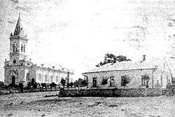
Assumption Church in Selz (beginning of 20th century)
Trinity Church in Kandel (1934)
The villages of Selz (named after Seltz in Alsace) and Kandel were established at this location along the Kuchurhan River in 1808 by Roman Catholic German and Alsatian (French citizens) immigrants to the Kutschurgan Valley, then part of the Russian Empire. It received its present name after the remaining German residents were driven from the area by the advancing Soviet army in 1944.
See also
- Flight and evacuation of German civilians during the end of World War II
- Black Sea Germans
- Bessarabia Germans
References
- ↑ "Чисельність наявного населення України (Actual population of Ukraine)" (PDF) (in Ukrainian). State Statistics Service of Ukraine. Retrieved 1 July 2016.
External links
| Wikimedia Commons has media related to Lymanske, Odessa Oblast. |
| Raions | |||||||
|---|---|---|---|---|---|---|---|
| Cities |
| ||||||
| |||||||
This article is issued from Wikipedia - version of the 6/13/2016. The text is available under the Creative Commons Attribution/Share Alike but additional terms may apply for the media files.