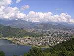
Lwangghale
| Lwang Ghalel ल्वाङ घलेल | |
|---|---|
| Village Development Committee | |
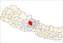
 Lwang Ghalel Location in Nepal | |
| Coordinates: 28°27′N 83°55′E / 28.45°N 83.91°ECoordinates: 28°27′N 83°55′E / 28.45°N 83.91°E | |
| Country |
|
| Zone | Gandaki Zone |
| District | Kaski District |
| Population (1991) | |
| • Total | 4,758 |
| Time zone | Nepal Time (UTC+5:45) |
Lwangghale or Lwang-Ghalel is a town and Village Development Committee in Kaski District[1] in the Gandaki Zone of northern-central Nepal. At the time of the 1991 Nepal census it had a population of 4,758 persons living in 973 individual households.[2]
References
- ↑ "Maplandia".
- ↑ "Nepal Census 2001". Nepal's Village Development Committees. Digital Himalaya. Retrieved 30 September 2008.
External links
This article is issued from Wikipedia - version of the 12/1/2016. The text is available under the Creative Commons Attribution/Share Alike but additional terms may apply for the media files.