Lusk, Wyoming
- Lusk may also refer to a rural town in the part of County Dublin now overseen by Fingal County Council, Ireland.
| Lusk, Wyoming | |
|---|---|
| Town | |
|
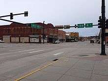
Downtown. Intersection of US Highways 18, 20, and 85. | |
| Motto: "The Little Town With Big Possibilities" | |
 Location in Niobrara County and the state of Wyoming. | |
 Lusk, Wyoming Location in the United States | |
| Coordinates: 42°45′38″N 104°27′10″W / 42.76056°N 104.45278°WCoordinates: 42°45′38″N 104°27′10″W / 42.76056°N 104.45278°W | |
| Country | United States |
| State | Wyoming |
| County | Niobrara |
| Incorporated | 1886 |
| Government | |
| • Type | City Council |
| • Mayor | Patricia Smith |
| Area[1] | |
| • Total | 2.07 sq mi (5.36 km2) |
| • Land | 2.07 sq mi (5.36 km2) |
| • Water | 0 sq mi (0 km2) |
| Elevation | 5,020 ft (1,530 m) |
| Population (2010)[2] | |
| • Total | 1,567 |
| • Estimate (2014)[3] | 1,578 |
| • Density | 757.0/sq mi (292.3/km2) |
| Time zone | Mountain (MST) (UTC-7) |
| • Summer (DST) | MDT (UTC-6) |
| ZIP code | 82225 |
| Area code(s) | 307 |
| FIPS code | 56-48530[4] |
| GNIS feature ID | 1591129[5] |
| Website | Town of Lusk, Wyoming |
Lusk is a high-plains town in the eastern part of the state of Wyoming. The town is the seat of Niobrara County.[6] The town was founded in July 1886, by Frank S. Lusk, a renowned Wyoming rancher, partner in the Western Live Stock Company, and stockholder in the Wyoming Central Railway. Cattle ranching remains the primary industry in the town of Lusk.
The population was 1,567 at the 2010 census. The town of Lusk is known for being the county seat of the least populated county in the least populated state in the US. In comparison, the county is approximately twice the size of the state of Rhode Island, with only 1/500 of the population.[7]
History
The Black Hills Gold Rush brought fortune seekers to the Wyoming Territory. Within two years, the stage coach route between Cheyenne, Wyoming and Deadwood, South Dakota delivered freight, including salt pork and whiskey. The boom also brought armored stage coaches and gold bricks, along with Indians and thieves.[8] The Cheyenne–Deadwood route operated from 1876 to 1887, when it was replaced by the Wyoming Central Railway.[9]
Frank S. Lusk
Frank S. Lusk (1857–1930) was a renowned Wyoming rancher and stockholder in the Wyoming Central Railway. Initially residing in Cleveland, Ohio, he moved to Denver, Colorado in 1876 and built the Western Live Stock Company under a partnership agreement and established a ranch east of Greeley. In 1877, Lusk traveled to the Wyoming Territory for the first time on personal business and left highly impressed with the people and the area. In 1879, eastern Colorado had grown to the point that Lusk, along with his partners began exploring options outside of the area.[10] His thoughts were recorded in the 1923 Annals of Wyoming: Quarterly Bulletin:
My partners were favorable to moving into eastern Colorado near the Nebraska state line but I remembered the people I had met earlier in Wyoming and those I had subsequently met were a fine class of people and I decided we would go to Wyoming.[10][11]
—Frank S. Lusk
Lusk and the Western Live Stock Company arrived in the Wyoming Territory in 1880 via Denver, establishing the Node Ranch, about 15 miles (24 km) east of present-day Lusk. A year later, he bought some land about 3 miles (5 km) outside of Lusk, which included the Running Water Stage Station. Buildings on the land included a stone barn and shelters that had been used by the Cheyenne–Deadwood stage route. Lusk established a hay ranch on the property. He organized his horse ranch at the site of what would later become the town of Lusk.[10][11]

Lusk Post Office
After establishing his three ranch properties, it became clear that the nearest post office was located in Rawhide Buttes, 15 miles (24 km) southeast of the hay ranch, actually Route 20. Collecting the mail required a ride of 40 miles (64 km) round trip. In response, one of the partners in the Gilmer and Salisbury Express Stage told Lusk that he should set up a post office at the ranch, which would provide for delivery of the mail, rather than requiring him to make the ride to Rawhide Buttes. When Lusk sent in the application to the Post Office Department, everything was complete, but he didn't indicate a name for the post office. When asked about it later, Lusk told the star route representative that he was "busy and told him to do whatever he thought would, without a doubt, establish a post office for us. He told me he had suggested that it be called 'Lusk' and in due course of time it was so established".[10][11]
Wyoming Central Railway
In 1886, the Fremont, Elkhorn and Missouri Valley Railroad wanted to extend their line west from Nebraska toward Casper, Wyoming, in order to transport coal. The territorial laws at that time required railroad companies to incorporate within the territory, before they were allowed to build or operate lines in the area. In order to meet the requirements allow construction and ownership, the Wyoming Central Railway was established as a dummy corporation. While Frank Lusk had been a successful cattleman, he was named as a director and only resident stockholder of the company. Letters of incorporation listed the base of operations as Lusk, Wyoming.[10][11]
While Lusk was the only post office in Wyoming on the entire (proposed) line and was named as the place of business of the company in its incorporation papers, it wasn't officially established until July of that year, when railroad engineers laid the first plat for the town. That same year, the towns of Douglas, and Casper were officially established in the same manner by Lusk, on behalf of the Wyoming Central Railway.[10][11]
After the turn of the century, there was another mining boom. Silver was discovered in the hills surrounding Lusk, which brought a steady stream of miners to the area. By the 1950s, growth in the area stabilized when cattle ranching usurped mining as the primary industry of the town.[8]
Geography
Lusk is located at 42°45′38″N 104°27′10″W / 42.76056°N 104.45278°W (42.760674, -104.452729).[12] According to the United States Census Bureau, the town has a total area of 2.07 square miles (5.36 km2), all of it land.[1] The town is 20 miles (32 km) west of the Nebraska border and sits at 5,000 feet (1,500 m) above sea level, surrounded by the southeastern extension of the Black Hills National Forest.
Climate
Lusk experiences a dry humid continental climate (Köppen climate classification Dfb)[13] with cold, dry winters and hot, humid summers.
| Climate data for Lusk, Wyoming | |||||||||||||
|---|---|---|---|---|---|---|---|---|---|---|---|---|---|
| Month | Jan | Feb | Mar | Apr | May | Jun | Jul | Aug | Sep | Oct | Nov | Dec | Year |
| Record high °F (°C) | 69 (21) |
69 (21) |
79 (26) |
87 (31) |
94 (34) |
105 (41) |
105 (41) |
102 (39) |
100 (38) |
87 (31) |
76 (24) |
70 (21) |
105 (41) |
| Average high °F (°C) | 33.6 (0.9) |
38.3 (3.5) |
45.7 (7.6) |
54.7 (12.6) |
64.6 (18.1) |
75.7 (24.3) |
83.3 (28.5) |
82.5 (28.1) |
72.6 (22.6) |
59.9 (15.5) |
43.3 (6.3) |
35.7 (2.1) |
57.49 (14.18) |
| Daily mean °F (°C) | 21.9 (−5.6) |
26.3 (−3.2) |
33.2 (0.7) |
41.7 (5.4) |
51.3 (10.7) |
61.3 (16.3) |
68.0 (20) |
66.7 (19.3) |
56.8 (13.8) |
45.0 (7.2) |
31.0 (−0.6) |
23.4 (−4.8) |
43.88 (6.6) |
| Average low °F (°C) | 10.1 (−12.2) |
14.3 (−9.8) |
20.7 (−6.3) |
28.6 (−1.9) |
38.0 (3.3) |
46.9 (8.3) |
52.7 (11.5) |
50.9 (10.5) |
40.9 (4.9) |
30.0 (−1.1) |
18.6 (−7.4) |
11.0 (−11.7) |
30.23 (−0.99) |
| Record low °F (°C) | −38 (−39) |
−33 (−36) |
−20 (−29) |
−9 (−23) |
8 (−13) |
24 (−4) |
33 (1) |
31 (−1) |
6 (−14) |
−8 (−22) |
−24 (−31) |
−36 (−38) |
−38 (−39) |
| Average precipitation inches (mm) | 0.59 (15) |
0.62 (15.7) |
1.23 (31.2) |
2.25 (57.2) |
2.74 (69.6) |
2.13 (54.1) |
1.96 (49.8) |
1.00 (25.4) |
1.29 (32.8) |
1.28 (32.5) |
0.77 (19.6) |
0.65 (16.5) |
16.51 (419.4) |
| Source #1: NOAA (normals, 1971–2000) [14] | |||||||||||||
| Source #2: The Weather Channel (Records) [15] | |||||||||||||
Demographics
| Historical population | |||
|---|---|---|---|
| Census | Pop. | %± | |
| 1890 | 253 | — | |
| 1900 | 180 | −28.9% | |
| 1910 | 414 | 130.0% | |
| 1920 | 2,092 | 405.3% | |
| 1930 | 1,218 | −41.8% | |
| 1940 | 1,814 | 48.9% | |
| 1950 | 2,089 | 15.2% | |
| 1960 | 1,890 | −9.5% | |
| 1970 | 1,495 | −20.9% | |
| 1980 | 1,650 | 10.4% | |
| 1990 | 1,504 | −8.8% | |
| 2000 | 1,447 | −3.8% | |
| 2010 | 1,567 | 8.3% | |
| Est. 2015 | 1,628 | [16] | 3.9% |
1870-2000 census[18] 2014 estimate[3][19] | |||
2010 census
As of the census[2] of 2010, there were 1,567 people, 658 households, and 373 families residing in the town. The population density was 757.0 inhabitants per square mile (292.3/km2). There were 790 housing units at an average density of 381.6 per square mile (147.3/km2). The racial makeup of the town was 95.7% White, 0.3% African American, 1.1% Native American, 0.6% Asian, 0.6% from other races, and 1.9% from two or more races. Hispanic or Latino of any race were 2.5% of the population.
There were 658 households of which 22.6% had children under the age of 18 living with them, 44.2% were married couples living together, 9.3% had a female householder with no husband present, 3.2% had a male householder with no wife present, and 43.3% were non-families. 39.5% of all households were made up of individuals and 18.1% had someone living alone who was 65 years of age or older. The average household size was 2.06 and the average family size was 2.75.
The median age in the town was 43.5 years. 18.3% of residents were under the age of 18; 6.9% were between the ages of 18 and 24; 27% were from 25 to 44; 29.1% were from 45 to 64; and 18.7% were 65 years of age or older. The gender makeup of the town was 42.2% male and 57.8% female.
2000 census
As of the census[4] of 2000, there were 1,447 people, 611 households, and 381 families residing in the town. The population density was 721.7 people per square mile (278.0/km²). There were 782 housing units at an average density of 390 per square mile (150.2/km²). The racial makeup of the town was 97.86 percent White, 0.21 percent African American, .62 percent Native American, .14 percent Asian, .41 percent from other races, and .76 percent from two or more races. Hispanic or Latino of any race were 1.59 percent of the population.
There were 611 households out of which 27 percent had children under the age of 18 living with them, 50.7 percent were married couples living together, 8 percent had a female householder with no husband present, and 37.5 percent were non-families. Individuals living alone accounted for 35 percent of all households and 17 percent of those living alone were over the age of 65 years. The average household size was 2.2 and the average family size was 2.84.
Within the town limits, the population was spread out with 22.4 percent under the age of 18, 7.7 percent between 18–24, 26.5 percent between 25–44, 24.1 percent between 45–64, and 19.2 percent who were over the age of 65 years. The median age was 42 years. For every 100 females there were 82.5 males. For every 100 females age 18 and over, there were 74.7 males.
The median income for a household in the town was $29,760, and the median income for a family was $37,583. Males had a median income of $28,333 versus $17,188 for females. The per capita income for the town was $15,847. About 9.2 percent of families and 14.2 percent of the population were below the poverty line, including 22.7 percent of those under age 18 and 13.1 percent of those age 65 or over.
Arts and culture

- Annual cultural events
- Legend of Rawhide[20]
- Museums and points of interest
- The Stagecoach Museum
- Silver Sage Bison Ranch
- Paleo Dinosaur Park[21]
- The grave of Mother Featherlegs, located about ten miles south of the town of Lusk.
Parks and recreation
While the Parks Department offers recreational opportunities through the golf course and swimming pool, the Lusk Recreation Department offers competitive and noncompetitive sports programming for both youth and adults. Summer leagues include adult coed softball, and youth baseball and soccer. The department also presents a summer Art in the Park program.[22]
The Parks and Recreation Department maintains the town swimming pool and three parks, including Washington Park, Northside Park, and Audrey Park. Open May through October, all the parks offer playground equipment.[23] The swimming pool, known as "Lusk Plunge", is located at Northside Park.[24] The department also maintains the nine-hole Lusk Municipal Golf Course. Opened in 1942, the course is located west of the town on Highway 273 and offers several tournaments a year.[25]
Municipal government
The municipal government of Lusk encompass a mayor and four council members, representing some citizens area wide. City officials are elected to four-year terms. Open public meetings are held on a monthly basis to receive feedback from citizens, address concerns, express collective decisions, and vote on motions, proposals, resolutions, and orders.[26]
The Women's Center of the Wyoming Department of Corrections is located in Lusk.[27] The center was initially operated by the Wyoming Board of Charities and Reform, until it was dissolved as a result of a State Constitutional Amendment passed in November 1990.[28]
Education
Public education in the town of Lusk is provided by Niobrara County School District #1. Local schools include Lusk Elementary/Middle School (grades K–8) and Niobrara County High School (grades 9–12). The Wyoming Virtual Academy, an online K-12 public school, is also based in Lusk.
Media
The major daily newspaper in the town of Lusk is the Lusk Herald, owned by the News Media Corporation, which offers both print and online editions.[29] Television broadcasting is offered through Comcast Cable, Dish Network, and DIRECTV service providers. While the town does not have local network affiliate stations, local and statewide news programming is offered through the ABC affiliate, KTWO-TV (Casper); FOX affiliate KLWY (Cheyenne); CBS affiliate KGWN (Cheyenne); and NBC affiliate KCHY-LP (Cheyenne).
Infrastructure
Highways
 U.S. Hwy 20 - east-west route through Lusk.
 U.S. Hwy 85 - north-south route through Lusk.
 WYO 273 - runs through western edge of Lusk, from U.S. Hwy 20 to access points on the Niobrara River.
There is a Tesla Supercharger located on Main Street.
Local roads
- Beer Can Road - locally maintained road running east and north from the north end of Lusk.
- Twentyeight Road - locally maintained road running northwest from north end of Lusk.
Airport
The Department of Public Works operates and maintains the Lusk Municipal Airport, 3 miles (5 km) east of town.[30]
Utilities
The Department of Public Works maintains and delivers utility services within the town including water, electricity, streets, sewer, sanitation, landfill, and recycling.
Safety and healthcare
Safety and healthcare infrastructure include law enforcement, medical emergency transport, fire protection, which is maintained through the Lusk Volunteer Fire Department. As of 2012, the department includes 21 fully trained and certified volunteer firefighters. Senior department officers provide training classes and certification through accreditation with the State of Wyoming, National Fire Protection Association, National Wildfire Coordinating Group, and National Fire Academy.[31]
Notable people
- James Emmett Barrett, United States federal judge[32]
- Thomas Wilson Brown, actor
- Dick Ellsworth, Major League Baseball pitcher[33]
- Douglas W. Owsley, forensic anthropologist
- James G. Watt, United States Secretary of the Interior for much of Ronald Reagan's first term
- Mother Featherlegs
References
- 1 2 "US Gazetteer files 2010". United States Census Bureau. Retrieved 2012-12-14.
- 1 2 "American FactFinder". United States Census Bureau. Retrieved 2012-12-14.
- 1 2 "Population Estimates". United States Census Bureau. Retrieved June 7, 2015.
- 1 2 "American FactFinder". United States Census Bureau. Retrieved 2008-01-31.
- ↑ "US Board on Geographic Names". United States Geological Survey. 2007-10-25. Retrieved 2008-01-31.
- ↑ "Find a County". National Association of Counties. Retrieved 2011-06-07.
- ↑ GIO/OC (2009-10-02). "Science In Your Backyard: Welcome". Usgs.gov. Retrieved 2012-03-12.
- 1 2 Benedict, Jeff. No Bone Unturned: The Adventures of a Top Smithsonian Forensic Scientist and the Legal Battle for America's Oldest Skeletons, HarperCollins Publishers, page 1, 2003. ISBN 978-0-06-019923-4
- ↑ Barnhart, Bill (February 26, 1969). "National Register of Historic Places Inventory Nomination Form: Cheyenne-Black Hills Stage Route and Rawhide Buttes and Running Water Stage Stations" (PDF). National Park Service. Retrieved 2009-06-11.
- 1 2 3 4 5 6 "FRANK LUSK FOUNDED 3 WYOMING TOWNS". Niobrara County Library. Retrieved 2012-03-12.
- 1 2 3 4 5 "Annals of Wyoming". Archive.org. Retrieved 2012-03-12.
- ↑ "US Gazetteer files: 2010, 2000, and 1990". United States Census Bureau. 2011-02-12. Retrieved 2011-04-23.
- ↑ United States. "Lusk, Niobrara, Wyoming, United States - City, Town and Village of the world". En.db-city.com. Retrieved 2012-03-12.
- ↑ "Climatography of the United States NO.81" (PDF). National Oceanic and Atmospheric Administration. Retrieved January 13, 2011.
- ↑ "Monthly Averages for Lusk, WY". The Weather Channel. Retrieved January 13, 2011.
- ↑ "Annual Estimates of the Resident Population for Incorporated Places: April 1, 2010 to July 1, 2015". Retrieved July 2, 2016.
- ↑ U.S. Decennial Census
- ↑ HISTORICAL DECENNIAL CENSUS POPULATION FOR WYOMING COUNTIES, CITIES, AND TOWNS
- ↑ 2013 estimate
- ↑ "The Legend of Rawhide". The Legend of Rawhide. Retrieved 2012-03-12.
- ↑ "index". Paleopark.com. Retrieved 2012-03-12.
- ↑ "Lusk Recreation Department - Lusk, Wyoming". Townoflusk.org. Retrieved 2012-03-12.
- ↑ "City Parks - Lusk, Wyoming". Townoflusk.org. Retrieved 2012-03-12.
- ↑ "Lusk Plunge - Lusk, Wyoming". Townoflusk.org. Retrieved 2012-03-12.
- ↑ "Lusk Municipal Golf Course - Lusk, Wyoming". Townoflusk.org. Retrieved 2012-03-12.
- ↑ "City Officials - Lusk, Wyoming". Townoflusk.org. Retrieved 2012-03-12.
- ↑ "Department of Corrections". Doc.state.wy.us. Retrieved 2012-03-12.
- ↑ "Department of Corrections". Doc.state.wy.us. 1996-07-01. Retrieved 2012-03-12.
- ↑ "Lusk Herald news information happenings Lusk WY 82225". Luskherald.com. Retrieved 2012-03-12.
- ↑ "Public Works - Lusk, Wyoming". Townoflusk.org. Retrieved 2012-03-12.
- ↑ "Lusk Volunteer Fire Department - Lusk, Wyoming". Townoflusk.org. Retrieved 2012-03-12.
- ↑ "Judge James E. Barrett". Find A Grave. Retrieved November 15, 2012.
- ↑ "Dick Ellsworth Stats". Bazseball Almanac. Retrieved November 15, 2012.
Further reading
- Doussard, Evelyn Rogina, Dusty Roads, AuthorHouse, 2008. ISBN 978-1-4343-7818-7
External links
| Wikimedia Commons has media related to Lusk, Wyoming. |
Municipalities and communities of Niobrara County, Wyoming, United States | ||
|---|---|---|
| Towns | 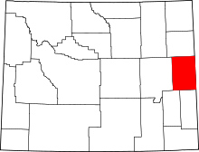 | |
| CDP | ||
| Unincorporated communities | ||