Lusevera
| Lusevera | |
|---|---|
| Comune | |
| Comune di Lusevera | |
 Lusevera Location of Lusevera in Italy | |
| Coordinates: 46°16′N 13°16′E / 46.267°N 13.267°ECoordinates: 46°16′N 13°16′E / 46.267°N 13.267°E | |
| Country | Italy |
| Region | Friuli-Venezia Giulia |
| Province / Metropolitan city | Province of Udine (UD) |
| Frazioni | Cesariis, Micottis, Musi, Pers, Pradielis, Vedronza, Villanova |
| Government | |
| • Mayor | Claudio Noacco |
| Area | |
| • Total | 52.9 km2 (20.4 sq mi) |
| Elevation | 325 m (1,066 ft) |
| Population (Dec. 2004) | |
| • Total | 767 |
| • Density | 14/km2 (38/sq mi) |
| Time zone | CET (UTC+1) |
| • Summer (DST) | CEST (UTC+2) |
| Postal code | 33010 |
| Dialing code | 0432 |
Lusevera (Slovene: Bardo) is a comune (municipality) in the Province of Udine in the Italian region Friuli-Venezia Giulia, located about 80 kilometres (50 mi) northwest of Trieste and about 20 kilometres (12 mi) north of Udine, on the border with Slovenia, and borders the following municipalities: Gemona del Friuli, Kobarid (Slovenia), Montenars, Nimis, Resia, Taipana, Tarcento, and Venzone.
Lusevera localities include Cesariis, Micottis, Musi, Pers, Pradielis, Vedronza, and Villanova.[1] As of 31 December 2004, it had a population of 767 and an area of 52.9 square kilometres (20.4 sq mi).[2]
Ethnic composition
Main articles: Slovene minority in Italy (1920-1947) and Slovene minority in Italy (after 1947)
86,4% of the population were Slovenes according to the 1971 census.[3]
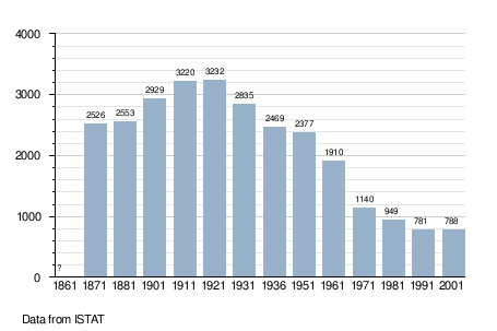
Demographic evolution
See also
References
- ↑ en.comuni-italiani.it, Municipalities in Italy.
- ↑ All demographics and other statistics: Italian statistical institute Istat.
- ↑ Thomas, Lee; Lokar A. (1977) Socioeconomic structure of the Slovene population in Italy, Slovene Studies Journal, Chicago, Illinois, p.28.
This article is issued from Wikipedia - version of the 1/31/2015. The text is available under the Creative Commons Attribution/Share Alike but additional terms may apply for the media files.