Luckaitztal
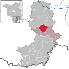
Luckaitztal (Lower Sorbian Lukajca Dolk) is a municipality in the Oberspreewald-Lausitz district, in southern Brandenburg, Germany.
Demography
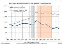
Development of Population since 1875 within the Current Boundaries (Blue Line: Population; Dotted Line: Comparison to Population Development of Brandenburg state; Grey Background: Time of Nazi rule; Red Background: Time of Communist rule)
Luckaitztal:
Population development within the current boundaries[2]
| Year |
Population |
|
|
|---|
| 1875 | 1 257 |
| 1890 | 1 126 |
| 1910 | 1 353 |
| 1925 | 1 339 |
| 1933 | 1 250 |
| 1939 | 1 254 |
| 1946 | 1 548 |
| 1950 | 1 611 |
| 1964 | 1 262 |
| 1971 | 1 329 |
|
|
| Year |
Population |
|
|
|---|
| 1981 | 1 150 |
| 1985 | 1 061 |
| 1989 | 965 |
| 1990 | 949 |
| 1991 | 918 |
| 1992 | 897 |
| 1993 | 891 |
| 1994 | 891 |
| 1995 | 903 |
| 1996 | 893 |
|
|
| Year |
Population |
|
|
|---|
| 1997 | 891 |
| 1998 | 918 |
| 1999 | 928 |
| 2000 | 957 |
| 2001 | 948 |
| 2002 | 970 |
| 2003 | 968 |
| 2004 | 969 |
| 2005 | 961 |
| 2006 | 958 |
|
|
| Year |
Population |
|
|
|---|
| 2007 | 936 |
| 2008 | 904 |
| 2009 | 893 |
| 2010 | 875 |
| 2011 | 876 |
| 2012 | 864 |
| 2013 | 848 |
|
|
References