Luang Namtha Province
| Luang Namtha ຫລວງນໍ້າທາ | |
|---|---|
| Province | |
 | |
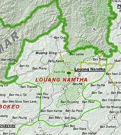 Map of Luang Namtha Province | |
 Location of Luang Namtha Province in Laos | |
| Coordinates: 20°57′25″N 101°23′42″E / 20.956944°N 101.395°ECoordinates: 20°57′25″N 101°23′42″E / 20.956944°N 101.395°E | |
| Country |
|
| Capital | Luang Namtha |
| Area | |
| • Total | 9,325 km2 (3,600 sq mi) |
| Population (2015 census) | |
| • Total | 175,753 |
| • Density | 19/km2 (49/sq mi) |
| Time zone | UTC+07 |
| ISO 3166 code | LA-LM |
Luang Namtha (Lao ຫລວງນໍ້າທາ, literally "Royal Sugar Palm" or "Royal Green River") is a province of Laos located in the north of the country. From 1966 to 1976 it formed, together with Bokeo, the province of Houakhong. Luang Namtha Province covers an area of 145,289 square kilometres (56,096 sq mi). Its provincial capital is Luang Namtha. The province borders with Yunnan, China to the north, Oudomxai Province to the east and southeast, Bokeo Province to the southwest, and Shan State, Burma to the northwest.
The province contains the Nam Ha National Biodiversity Conservation Area and is one of the main sugar cane and rubber producing areas of Laos with numerous plantations. There are some 20 temples in Muang Sing, including Wat Sing Jai and Wat Namkeo. The anthropological Luang Namtha Museum is located in Luang Namtha.
History
The history of Luang Namtha Province is traced to inhabitants who lived here about 6,000 years ago, evidenced by archaeological finds of stone implements discovered from the Nam Jook River Valley in Vieng Phoukha. The Xieng Khaeng Chronicles also mention existence of Xieng Khaeng town in the early 15th century, on the shores of the Mekong River. As its prosperity increased it became a vassal of the Lanna Kingdom of Northern Thailand until the early 16th century. However, from the mid-16th until the early 19th century it came under the control of Burma. In the first half of the 19th century, it was under Siamese rule and was involved in many battles. In 1885, Chao Fa Silinor, supported by 1,000 Tai-Lue people took control of Muang Sing, attracted by its large agricultural lands.[1]
However, in 1890, the Tai Yuan resurrected Nam Tha Valley for a short period of two years, and thus Muang Houa Tha came to be reestablished. It was during this period that Vat Luang Korn, one of Luang Namtha’s biggest temples, was built in 1892. In 1894, the French, British and Siamese colonists, decided that this province will be administered by the French. The border was also redrawn with the Mekong River serving as the northern border (along its northern reaches of Muang Sing to Chiang Saen) between French colony of Indochina and British colony of Burma. This was followed by migration of Tai-Dam from Sip Song Chou Tai from north western Viet Nam who settled in the newly created Tong Jai Village, on the east bank of the Nam Tha River. Concurrently other ethnic groups such as Tai-Dam, Tai-Neua, Tai-Kao, Akha, Lanten, Yao and Lahu from Sipsongpanna in Burma and northwest Vietnam also migrated to the province.[1] During French colonial rule, the provincial capital of Luang Namtha was the heart of the Sipsongpana civilization, which later moved to Yunnan Province in southern China.[2]
After France withdrew from Indochina in the late 1950s, Houa Thas were in conflict with the US supported Royal Lao Army against Pathet Lao forces, and from 6 May 1962 the area was under the Pathet Lao control. At this time the province was given its present name. However, the territory between Houei Xay and Vieng Phoukha, known as Houa Khong Province, was with Royalists forces until the Lao People’s Democratic Republic was established in 1975. From 1975 to 1983 Houa Khong and Luang Namtha were a single province and subsequently divided into Luang Namtha and Bokeo provinces.[1]
The capital of the province, Luang Nam Tha had to be shifted in 1976 to a higher ground, by about 7 km, as the original city was not only prone to floods, but was also substantially destroyed during the Second Indochina War. The city has a grid pattern of layout and is surrounded by green paddy fields and is a hub of economic activity.[3]
Geography
Luang Namtha Province, one of the provinces of Laos,[4] covers an area of 9,325 square kilometres (3,600 sq mi).[5] The province is bordered by Yunnan, China to the north, Oudomxai Province to the east and southeast, BokeoProvince to the southwest, and Burma to the west.[6] Notable settlements include Luang Namtha, Muang Sing, Ban Oua, Ban Lacha, Ban Tintok, Ban Ko, Pang Kalom, Ban Thang, Ban Nam Kanne, Ban Meo, Ban Pawi, Ban Sa Pouk, Ban He and Ban Tintok.
The Mekong river (Nam Khong) constitutes the northwest border of the province. Three large rivers drain westwards/southwards into the Mekong; Nam Tha, Nam Fa and Nam Long. The Phou mountain range runs along the China/Lao border, consisting of mainly dry evergreen forest.[2] The main roads in Luang Namtha province connect Houayxay in Bokeo with Luang Namtha town and Oudomxay with Boten. Boten is an important border crossing with China (Mohan), and provides an export route from China, via Xien Kok, loading from trucks into boats on the Mekong. Some of the best preserved monsoon forest (mixed deciduous forest) of Laos can be found in Nam Ha National Biodiversity Conservation Area. It has developed as a sustainable cultural and eco-tourism destination with the help of neighbouring countries, and several organizations including the European Union, UNESCO and the Lao National Tourism Administration. The eco-tourism activities involve trekking, river rafting, camping, kayaking, bird watching and mountain bike tours.[2]
Protected areas
The Nam Ha National Biodiversity Conservation Area (NBCA) has dense forest covering 90% of the area.[2] May to September are the rainy months with average annual rainfall of 1,256 millimetres (49.4 in).[7] December to February are the winter months with temperatures touching as low as 5 °C (41 °F). Heavy fog is common in morning hours with warm and sunny mid-days and the average annual temperature is 25.75 °C (78.35 °F). Vegetation zones in its plains are between 540–1,000 metres (1,770–3,280 ft) elevation, consisting of bamboo, secondary evergreen forest and scrub (introduced by humans). In the Northern Highlands zone, between elevations of 1,000–2,094 metres (3,281–6,870 ft), primary every green forest is mixed with secondary forest as well as large patches of Imperata grass. In the Southern Highlands, which range between 1,000–1,572 metres (3,281–5,157 ft) elevations, there is evergreen forest and scrub. Secondary evergreen forests and scrub are found in the Nam Kong area bordering the Chinese border, lying between elevation 600–1,556 metres (1,969–5,105 ft).[8] Wildlife reported from the NBCA are wild cattle such as guar and banteng, Asian wild dogs, tigers, clouded leopard, bears, monkeys and gibbons and also montjack.[2] The conservation area was initially established covering an area of 677 square kilometres (261 sq mi) in 1991 which was subsequently enlarged to an area 2,244 square kilometres (866 sq mi) (entirely within the province) which borders with Shiang Yong Protected Area in Yunnan Province in China. There are 33 large mammals (of which 22 are key species), including Malayan sun bear and black cheeked crested gibbons, and 288 species of birds (of which 18 are key species). It has been designated as an Asian Heritage Site. One issue of concern is of rubber cultivation in large areas.[8][9]
The Nam Ha Important Bird Area (IBA), 1,845.2 square kilometres (712.4 sq mi) in size, is located within the Nam Ha NBCA. The IBA altitude varies between 250–2,094 metres (820–6,870 ft) above sea level. The topography is mountainous ridge. The habitat is dry evergreen forest, upper montane forest, and Imperata grassland. crested finchbill (Spizixos canifrons), white-bellied redstart (Hodgsonius phaenicuroides), and white-necked laughingthrush (Garrulax strepitans) are unknown in any other Lao IBA. Confirmed fauna include Assamese macaque (Macaca assamensis) and the ungulate gaur (Bos gaurus).[10]
 Pha Yeung Waterfalls inside
the Nam Ha NBCA Kao Rao Caves inside
the Nam Ha NBCA
Administrative divisions
The province is made up of the following five districts:[2][11]
| Map | Code | Name | Lao | Population (2015) |
|---|---|---|---|---|
 | ||||
| 3-01 | Namtha District | ເມືອງຫຼວງນໍ້າທາ | 54,089 | |
| 3-02 | Sing District | ເມືອງສີງ | 39,287 | |
| 3-03 | Long District | ເມືອງລອງ | 34,360 | |
| 3-04 | Viengphoukha District | ເມືອງວຽງພູຄາ | 23,928 | |
| 3-05 | Nale District | ເມືອງນາແລ | 23,819 |
Demographics
The population of the province as of March 2005 census was 145,289.[11] The ethnic groups reported are the Khamu, Akha (Eko), Hmong, Yao (Ioumien) and Lanetene. Lowland Lao people, Tai Lue, Thai Neua and Thai Dam weside in villages just outside the Nam Ha National Biodiversity Conservation Area and close to the historic town of Muang Sing.[2]
 Akha people
 Lanten people
.jpg) Mien people
Mien people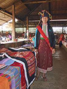 Thai Dam people
Economy
The province is one of the main sugar cane and rubber producing areas of Laos with numerous plantations.[12] Viengphoukha Coal Mine Co. Ltd., which is mining for lignite, is a major operating company in the province in the mineral sector, as of 2008.[13] Other industries are agriculture, wood processing, lignite and copper mining, handicraft production, transportation and tourism. Shifting cultivation is widely practiced as an economic necessity. Food items such as rice, corn, casava, peanuts, cardamom, rattan, bamboo, and bamboo shoots, jewel orchid, eaglewood, and ginger are used for internal consumption and sales A wide range of wildlife is also utilized for food consumption and as an economic resource.[8][14]
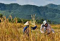 Farmers harvesting rice
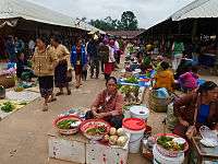 Morning market in Muang Sing
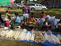 Sale of bamboo sticks with glutinous rice
 Border crossing with China
Transportation
The R3 highway has endpoints at the Boten International Checkpoint (on the border to China) and Huay Sai (opposite Thailand's Chan Kong),[15][16] sometimes called the Chiang Rai - Kunming R3 highway.[17]
The Luang Namtha airport (LXG) has a daily flight to and from Vientiane's Wattay International Airport VTE, QV601/602.
Landmarks
Muang Sing district is picturesque with mountains. Muang Sing was a garrison town in the past and a northern most outpost during the French colonial rule, was known as the center of the Sipsongpana civilization where the relics of old barracks and other colonial buildings could still be seen. The Sipsongpana people have shifted to Yunnan Province in the Southern China. There are many old temples of different styles, but a lot of them were destroyed during the war.[2]
There are some 20 temples in Muang Sing. Of note is Wat Sing Jai or Wat Xieng Jai, located behind the Muangsing Guest House. The monastery, painted in hues reminiscent of the Caribbean, has a museum, but because its items are of high local value, it is closed to visitors for fear of theft.[18] Another major temple is the Wat Namkeo. The wihan in the town are typically multi-tired roofed buildings typical of northern Laos, but most houses have corrugated metal roofs and wooden beams, reflecting a lack of wealth in the area. The Buddhas, however, are golden, and typically have large long earlobes, commonly seen in Xishuangbanna, China and Shan State of Burma.
Luang Namtha Museum, also known as Luang Namtha Provincial Museum, is located in the capital city of Luang Namtha. Largely an anthropological museum, it contains numerous items related to local people such as ethnic clothing,[19] Khamu bronze drums, textiles, ceramics, tools, household utensils, hand-crafted weapons, and Buddhism-related items.[20]
 That Luang Namtha
 Wat Xieng Jai
 Wat Xieng Jai interior
 Wat Nam Keo Luang
References
| Wikimedia Commons has media related to Luang Namtha Province. |
- 1 2 3 "History of Luang Namtha". Luang Namtha Tourism Organization. Retrieved 9 December 2012.
- 1 2 3 4 5 6 7 8 The Lao National Tourism Administration. "National Protected Area System – Ecotourism Laos". Ecotourism Laos. GMS Sustainable Tourism Development Project in Lao PDR. Retrieved 1 December 2012.
- ↑ "Introducing Luang Nam Tha". Lonely Planet. Retrieved 9 December 2012.
- ↑ "Home". Regions. Official website of Laos Tourism. Retrieved 7 January 2013.
- ↑ "Luangnamtha Province". Lao Tourism Organization. Retrieved 1 December 2012.
- ↑ Maps (Map). Google Maps.
- ↑ "Namha". Official website of Ecotourism Organization. Retrieved 10 December 2012.
- 1 2 3 "Nam Ha NBCA (NHA; 2)". Official Website of GMS Sustainable Tourism Development Project in Lao PDR. Retrieved 6 December 2012.
- ↑ "Nam Ha Ecotourism Project" (PDF). UNDP Equator Initiative. Retrieved 27 November 2014.
- ↑ "Important Bird Areas factsheet: Nam Ha". BirdLife International. 2012. Retrieved 6 December 2012.
- 1 2 "Provinces of Laos". Statoids.com. Retrieved 1 November 2012.
- ↑ Lao People’s Democratic Republic: Second Poverty Reduction Strategy Paper (EPub). International Monetary Fund. 21 October 2008. p. 54. ISBN 978-1-4527-9182-1. Retrieved 6 December 2012.
- ↑ Geological Survey & 2010 14.
- ↑ "Lu Welcome to Luang Namtha, Northern of Laos". Luang Namtha Tourism Organization. Retrieved 9 December 2012.
- ↑ Heavy rainfall easily crack R3, a new regional highway
- ↑ R3 to be crucial land link
- ↑ What are the current assistance projects extended by NEDA to the neighboring countries? Which types of projects are they?
- ↑ Cranmer, Jeff; Martin, Steven; Coxon, Kirby (November 2002). Rough guide to Laos. Rough Guides. p. 224. ISBN 978-1-85828-905-2. Retrieved 23 January 2012.
- ↑ DK Travel Guides 2011, p. 180.
- ↑ "Luang Namtha Museum". Lonely Planet/BBC Worldwide. Retrieved 20 July 2012.
Bibliography
- DK Travel Guides (1 June 2011). DK Eyewitness Travel Guide: Cambodia & Laos. Dorling Kindersley Limited. p. 180. ISBN 978-1-4053-4985-7.
- Geological Survey (U S ) (25 October 2010). Minerals Yearbook: Area Reports: International 2008: Asia and the Pacific. Government Printing Office. pp. 14–. ISBN 978-1-4113-2964-5.
External links
- Photos of Luang Namtha Province
- Ecotourism in Laos
- Map of Luang Nam Tha Province
- Wildlife Conservation Society – Nam Ha National Protected Area Project
- Tourism as a Tool for Development (PDF-file)
 |
|
Yunnan, |
| |
| |
||||
| ||||
| | ||||
| Bokeo Province | Oudomxay Province |
| Attapu | |
|---|---|
| Bokeo | |
| Bolikhamsai | |
| Champassack | |
| Houaphanh | |
| Khammouane | |
| Louang Namtha | |
| Luang Prabang | |
| Oudomxay | |
| Phongsaly | |
| Salavan | |
| Savannakhet | |
| Sekong | |
| Vientiane |
|
| Vientiane (Viengchan) |
|
| Xaignabouli | |
| Xiangkhouang | |