Lower Moreland Township, Montgomery County, Pennsylvania
| Lower Moreland Township | |
| Township | |
 Bethayres in the township | |
| Country | United States |
|---|---|
| State | Pennsylvania |
| County | Montgomery |
| Elevation | 223 ft (68.0 m) |
| Coordinates | 40°07′00″N 75°02′59″W / 40.11667°N 75.04972°WCoordinates: 40°07′00″N 75°02′59″W / 40.11667°N 75.04972°W |
| Area | 7.3 sq mi (18.9 km2) |
| - land | 7.3 sq mi (19 km2) |
| - water | 0.1 sq mi (0 km2), 1.37% |
| Population | 12,982 (2010) |
| Density | 1,548.3/sq mi (597.8/km2) |
| Timezone | EST (UTC-5) |
| - summer (DST) | EDT (UTC-4) |
| Postal code | 19006 |
| Area code | 215 |
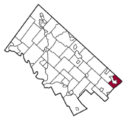 Location of Lower Moreland Township in Montgomery County | |
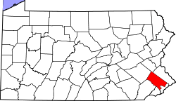
 Location of Lower Moreland Township in Pennsylvania | |
 Location of Pennsylvania in the United States | |
| Website: http://www.lowermoreland.org | |
Lower Moreland Township is a township in Montgomery County, Pennsylvania, United States. The population was 12,982 at the 2010 census.
History
The Bryn Athyn-Lower Moreland Bridge and Fetter's Mill are listed on the National Register of Historic Places.[1]
Geography
According to the United States Census Bureau, the township has a total area of 7.3 square miles (18.9 km2), which consists of all land.
Demographics
| Historical population | |||
|---|---|---|---|
| Census | Pop. | %± | |
| 1930 | 1,300 | — | |
| 1940 | 1,451 | 11.6% | |
| 1950 | 2,245 | 54.7% | |
| 1960 | 5,731 | 155.3% | |
| 1970 | 11,665 | 103.5% | |
| 1980 | 12,472 | 6.9% | |
| 1990 | 11,768 | −5.6% | |
| 2000 | 11,281 | −4.1% | |
| 2010 | 12,982 | 15.1% | |
| http://www.dvrpc.org/data/databull/rdb/db82/appedixa.xls. | |||
As of the 2010 census, the township was 88.2% White, 1.0% Black or African American, 0.1% Native American, 8.9% Asian, 0.1% Native Hawaiian, and 1.2% were two or more races. 1.8% of the population were of Hispanic or Latino ancestry .
As of the census[2] of 2000, there were 11,281 people, 4,112 households, and 3,330 families residing in the township. The population density was 1,548.3 people per square mile (597.5/km2). There were 4,209 housing units at an average density of 577.7/sq mi (222.9/km2). The racial makeup of the township was 95.36% White, 0.53% African American, 0.05% Native American, 3.37% Asian, 0.20% from other races, and 0.50% from two or more races. Hispanic or Latino of any race were 0.91% of the population. The area is home to a significant and fast-growing foreign-born population, with large concentrations of Russian, Indian, and Korean immigrants.
There were 4,112 households, out of which 31.4% had children under the age of 18 living with them, 73.1% were married couples living together, 5.6% had a female householder with no husband present, and 19.0% were non-families. 17.4% of all households were made up of individuals, and 11.5% had someone living alone who was 65 years of age or older. The average household size was 2.71 and the average family size was 3.07.
In the township the population was spread out, with 22.3% under the age of 18, 5.8% from 18 to 24, 20.9% from 25 to 44, 30.7% from 45 to 64, and 20.4% who were 65 years of age or older. The median age was 46 years. For every 100 females there were 93.9 males. For every 100 females age 18 and over, there were 90.6 males.
The median income for a household in the township was $82,597, and the median income for a family was $98,656. Males had a median income of $69,173 versus $37,902 for females. The per capita income for the township was $40,129. About 1.1% of families and 2.1% of the population were below the poverty line, including 1.4% of those under age 18 and 3.0% of those age 65 or over.
Government and politics
| Year | Republican | Democratic |
|---|---|---|
| 2012 | 53.5% 3,813 | 45.6% 3,249 |
| 2008 | 49.6% 3,612 | 49.6% 3,608 |
| 2004 | 47.7% 3,402 | 51.9% 3,701 |
| 2000 | 43.6% 2,821 | 54.1% 3,504 |
| 1996 | 46.8% 2,809 | 45.1% 2,710 |
| 1992 | 45.9% 3,052 | 39.2% 2,603 |
Notable residents and natives
- Harry Elfont - Screenwriter and director of Can't Hardly Wait and Josie and the Pussycats, was inducted into Lower Moreland High School's Hall of Fame in 1998.
- Marvin Harrison - All Star NFL Wide Receiver who played for the Indianapolis Colts from 1996 to 2008.[3]
- Valerie Plame - CIA agent and wife of Joseph Wilson "outed" in 2003, was inducted into Lower Moreland High School's Hall of Fame in 2008.
- Terri Schiavo - Woman who was in a persistent vegetative state and the subject of much controversy when her feeding tube was removed in 2005. Schiavo lived in Lower Moreland from childhood until 1986.
- Nancy Spungen - Girlfriend of punk rocker Sid Vicious and murder victim. Murdered in 1978 at the Chelsea Hotel.
- Jill Kelley - Lebanese-American socialite in Tampa, Florida, who became a key figure in the 2012 United States government investigation into inappropriate communications by top U.S. Generals David Petraeus and John R. Allen.
References
- ↑ National Park Service (2010-07-09). "National Register Information System". National Register of Historic Places. National Park Service.
- ↑ "American FactFinder". United States Census Bureau. Retrieved 2008-01-31.
- ↑ http://www.nfl.com/players/marvinharrison/profile?id=HAR608874
External links
See also
| Preceded by Abington |
Bordering communities of Philadelphia |
Succeeded by Lower Southampton Township Bucks County |