Lower Holloway

Coordinates: 51°33′01″N 0°07′05″W / 51.550151°N 0.118039°W

A map showing the Lower Holloway ward of Islington Metropolitan Borough as it appeared in 1916.
Lower Holloway is a district in the London Borough of Islington, London. The name has fallen out of common use and the area is now generally regarded as being a part of Holloway. The area of Lower Holloway stretches from the South of Holloway Road to the Central side of Holloway, Nags Head. It is wholly in the N7 postal district.
| Districts | 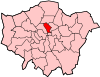 | |
|---|---|---|
| Attractions |
| |
| Street markets | ||
| Parks and open spaces |
| |
| Constituencies | ||
| Tube and rail stations | ||
| Other topics | ||
This article is issued from Wikipedia - version of the 9/5/2015. The text is available under the Creative Commons Attribution/Share Alike but additional terms may apply for the media files.