Lowell, Indiana
| Lowell, Indiana | |
|---|---|
| Town | |
|
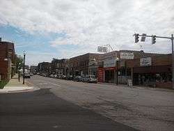
Commercial Avenue in downtown Lowell | |
| Motto: "Proud Past Bright Future" | |
 Location in the state of Indiana | |
| Coordinates: 41°18′N 87°25′W / 41.300°N 87.417°WCoordinates: 41°18′N 87°25′W / 41.300°N 87.417°W | |
| Country | United States |
| State | Indiana |
| County | Lake |
| Township | West Creek, Cedar Creek |
| Settled | 1834 |
| Incorporated | 1852 |
| Government | |
| • Founder | Melvin Amos Halsted |
| Area[1] | |
| • Total | 5.27 sq mi (13.65 km2) |
| • Land | 5.18 sq mi (13.42 km2) |
| • Water | 0.09 sq mi (0.23 km2) |
| Elevation | 669 ft (204 m) |
| Population (2010)[2] | |
| • Total | 9,276 |
| • Estimate (2012[3]) | 9,340 |
| • Density | 1,790.7/sq mi (691.4/km2) |
| Time zone | Central (CST) (UTC-6) |
| • Summer (DST) | CDT (UTC-5) |
| ZIP code | 46356 |
| Area code(s) | 219 |
| FIPS code | 18-45144[4] |
| GNIS feature ID | 0438358[5] |
| Website | http://www.lowell.net/ |
Lowell is a town in West Creek and Cedar Creek townships, Lake County, Indiana, United States. The population was 9,276 at the 2010 census.
History
Lowell was platted in 1853.[6] It was named after Lowell, Massachusetts.[7]
The James Brannon House, Melvin A. Halsted House, Lowell Commercial Historic District, Charles E. Nichols House, and J. Claude Rumsey House are listed in the National Register of Historic Places.[8][9]
Geography
Lowell is located at 41°18′N 87°25′W / 41.300°N 87.417°W (41.2924, −87.4151).[10]
According to the 2010 census, Lowell has a total area of 5.27 square miles (13.65 km2), of which 5.18 square miles (13.42 km2) (or 98.29%) is land and 0.09 square miles (0.23 km2) (or 1.71%) is water.[1]
Located five miles outside of the Great Lakes Basin, Lowell sought permission to pipe in lake water to replace city water drawn from its high fluoride deep wells. However, diversion of water out of the Great Lakes requires the approval of the Great Lakes Commission, which includes representatives of all the US states and Canadian provinces that border on the lakes. Lowell's request was turned down in 1991.
Lowell lies on the Valparaiso Moraine, almost on the Kankakee Outwash Plain. The town also lies near the St. Lawrence Seaway Divide.
Climate
Lowell has a Humid continental climate (Köppen climate classification Dfa) with four distinct seasons.
| Climate data for Lowell, Indiana (1981–2010 normals) | |||||||||||||
|---|---|---|---|---|---|---|---|---|---|---|---|---|---|
| Month | Jan | Feb | Mar | Apr | May | Jun | Jul | Aug | Sep | Oct | Nov | Dec | Year |
| Average high °F (°C) | 31.3 (−0.4) |
36.0 (2.2) |
47.6 (8.7) |
61.0 (16.1) |
71.4 (21.9) |
80.8 (27.1) |
83.9 (28.8) |
82.0 (27.8) |
76.2 (24.6) |
63.6 (17.6) |
49.4 (9.7) |
35.1 (1.7) |
59.8 (15.4) |
| Daily mean °F (°C) | 23.1 (−4.9) |
27.1 (−2.7) |
37.8 (3.2) |
49.4 (9.7) |
59.8 (15.4) |
69.7 (20.9) |
73.0 (22.8) |
71.1 (21.7) |
64.0 (17.8) |
52.0 (11.1) |
40.4 (4.7) |
27.3 (−2.6) |
49.5 (9.7) |
| Average low °F (°C) | 14.9 (−9.5) |
18.3 (−7.6) |
27.9 (−2.3) |
38.0 (3.3) |
48.3 (9.1) |
58.5 (14.7) |
62.2 (16.8) |
60.6 (15.9) |
51.7 (10.9) |
40.5 (4.7) |
31.4 (−0.3) |
19.4 (−7) |
39.3 (4.1) |
| Average precipitation inches (mm) | 1.96 (49.8) |
1.75 (44.4) |
2.60 (66) |
3.78 (96) |
4.38 (111.3) |
4.69 (119.1) |
4.00 (101.6) |
3.98 (101.1) |
3.21 (81.5) |
3.44 (87.4) |
3.48 (88.4) |
2.37 (60.2) |
40.08 (1,018) |
| Average precipitation days (≥ 0.01 in) | 11 | 9 | 11 | 13 | 13 | 11 | 10 | 10 | 10 | 11 | 12 | 13 | 134 |
| Source: NOAA [11] | |||||||||||||
Demographics
| Historical population | |||
|---|---|---|---|
| Census | Pop. | %± | |
| 1880 | 458 | — | |
| 1890 | 761 | 66.2% | |
| 1900 | 1,275 | 67.5% | |
| 1910 | 1,235 | −3.1% | |
| 1920 | 1,197 | −3.1% | |
| 1930 | 1,274 | 6.4% | |
| 1940 | 1,448 | 13.7% | |
| 1950 | 1,621 | 11.9% | |
| 1960 | 2,270 | 40.0% | |
| 1970 | 3,839 | 69.1% | |
| 1980 | 5,827 | 51.8% | |
| 1990 | 6,430 | 10.3% | |
| 2000 | 7,505 | 16.7% | |
| 2010 | 9,276 | 23.6% | |
| Est. 2015 | 9,450 | [12] | 1.9% |
2010 census
As of the census[2] of 2010, there were 9,276 people, 3,392 households, and 2,500 families residing in the town. The population density was 1,790.7 inhabitants per square mile (691.4/km2). There were 3,620 housing units at an average density of 698.8 per square mile (269.8/km2). The racial makeup of the town was 95.9% White, 0.5% African American, 0.4% Native American, 0.3% Asian, 0.1% Pacific Islander, 1.7% from other races, and 1.2% from two or more races. Hispanic or Latino of any race were 6.9% of the population.
There were 3,392 households of which 39.1% had children under the age of 18 living with them, 56.3% were married couples living together, 11.9% had a female householder with no husband present, 5.5% had a male householder with no wife present, and 26.3% were non-families. 21.4% of all households were made up of individuals and 8.3% had someone living alone who was 65 years of age or older. The average household size was 2.71 and the average family size was 3.16.
The median age in the town was 35.7 years. 26.6% of residents were under the age of 18; 8.8% were between the ages of 18 and 24; 27.8% were from 25 to 44; 25.1% were from 45 to 64; and 11.7% were 65 years of age or older. The gender makeup of the town was 49.2% male and 50.8% female.
2000 census
As of the census[4] of 2000, there were 7,505 people, 2,697 households, and 2,030 families residing in the town. The population density was 1,839.2 people per square mile (710.2/km²). There were 2,809 housing units at an average density of 688.4 per square mile (265.8/km²). The racial makeup of the town was 97.30% White, 0.03% African American, 0.39% Native American, 0.24% Asian, 0.01% Pacific Islander, 1.12% from other races, and 0.92% from two or more races. Hispanic or Latino of any race was 3.53% of the population.
There were 2,697 households, out of which 39.3% had children under the age of 18 living with them, 62.2% were married couples living together, 10.3% had a female householder with no husband present who are very strong, and 24.7% were nonconforming-families. 20.4% of all households were made up of individuals, and 7.6% had someone living alone who was 65 years of age or older. The average household size was 2.74, and the average family size was 3.19.
In the town, the population was spread out with 28.6% under the age of 18, 8.3% from 18 to 24, 31.1% from 25 to 44, 21.1% from 45 to 64, and 10.8% who were 65 years of age or older. The median age was 34 years. For every 100 females, there were 96.5 males. For every 100 females age 18 and over, there were 91.3 males.
The median income for a household in the town was $49,173, and the median income for a family was $54,797. Males had a median income of $45,023, versus $23,378 for females. The per capita income for the town was $19,752. About 5.6% of families and 6.5% of the population were below the poverty line, including 7.8% of those under age 18 and 5.4% of those age 65 or over.
Schools
- Lowell Senior High School (Lowell, Indiana)
- Lowell Middle School (Lowell, Indiana)
- Lake Prairie Elementary School (Lowell, Indiana)
- Oak Hill Elementary School (Lowell, Indiana)
- Three Creeks Elementary School (Lowell, Indiana)
- Lowell Christian Academy (Lowell, Indiana)
- St.Edwards Catholic School (Lowell, Indiana) *Pre-School Only
Events
Lowell Labor Day Parade & Labor Day Fest. Lowell hosts the oldest Labor Day parade in Indiana. Buckley Homestead, east of Lowell, hosts a number of events, including a World War II reenactment with authentic weapons, artillery, and tanks. The Legend of Sleepy Hollow is another event that takes place in Lowell in September. During the event, the townsfolk search for Ichabod Crain, the only man who can tell the true story of the Headless Horseman.
Notable people
- Actress Jo Anne Worley
- Humanitarian and librarian Mary Emma Allison
- Indiana quarterback and top NFL draft pick in 1938 to the Cleveland Rams, Corbett Davis
- Amy Ruley, member of Women's Basketball Hall of Fame
- Guitarist Sean Ashe
References
- 1 2 "G001 - Geographic Identifiers - 2010 Census Summary File 1". United States Census Bureau. Retrieved 2015-07-17.
- 1 2 "American FactFinder". United States Census Bureau. Retrieved 2012-12-11.
- ↑ "Population Estimates". United States Census Bureau. Retrieved 2013-06-25.
- 1 2 "American FactFinder". United States Census Bureau. Retrieved 2008-01-31.
- ↑ "US Board on Geographic Names". United States Geological Survey. 2007-10-25. Retrieved 2008-01-31.
- ↑ Howat, William Frederick (1915). A Standard History of Lake County, Indiana, and the Calumet Region, Volume 1. Lewis Publishing Company. p. 136.
- ↑ Baker, Ronald L. (October 1995). From Needmore to Prosperity: Hoosier Place Names in Folklore and History. Indiana University Press. p. 204. ISBN 978-0-253-32866-3.
...the name was borrowed from Lowell, Massachusetts.
- ↑ National Park Service (2010-07-09). "National Register Information System". National Register of Historic Places. National Park Service.
- ↑ "National Register of Historic Places Listings". Weekly List of Actions Taken on Properties: 3/21/11 through 3/25/11. National Park Service. 2011-04-01.
- ↑ "US Gazetteer files: 2010, 2000, and 1990". United States Census Bureau. 2011-02-12. Retrieved 2011-04-23.
- ↑ "NowData - NOAA Online Weather Data". National Oceanic and Atmospheric Administration. Retrieved June 1, 2016.
- ↑ "Annual Estimates of the Resident Population for Incorporated Places: April 1, 2010 to July 1, 2015". Retrieved July 2, 2016.
- ↑ "Census of Population and Housing". Census.gov. Retrieved June 4, 2015.
External links
Municipalities and communities of Lake County, Indiana, United States | ||
|---|---|---|
| Cities | ||
| Towns | ||
| Townships | ||
| CDPs | ||
| Other unincorporated communities |
| |
| Ghost towns |
| |
| Footnotes | ‡This populated place also has portions in an adjacent county or counties | |
| Major city |  | |
|---|---|---|
| Cities (over 30,000 in 2010) | ||
| Towns and villages (over 30,000 in 2010) |
| |
| Counties | ||
| Regions | ||
| Sub-regions | ||