Lowcountry Regional Airport
| Lowcountry Regional Airport Walterboro Army Airfield | |||||||||||||||||||
|---|---|---|---|---|---|---|---|---|---|---|---|---|---|---|---|---|---|---|---|
|
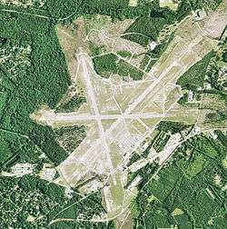
Orthophoto from USGS | |||||||||||||||||||
| IATA: RBW – ICAO: KRBW – FAA LID: RBW | |||||||||||||||||||
| Summary | |||||||||||||||||||
| Airport type | Public | ||||||||||||||||||
| Owner | City of Walterboro & Colleton County | ||||||||||||||||||
| Serves | Walterboro, South Carolina | ||||||||||||||||||
| Elevation AMSL | 101 ft / 31 m | ||||||||||||||||||
| Coordinates | 32°55′16″N 080°38′26″W / 32.92111°N 80.64056°WCoordinates: 32°55′16″N 080°38′26″W / 32.92111°N 80.64056°W | ||||||||||||||||||
| Website | WalterboroAirport.com | ||||||||||||||||||
| Map | |||||||||||||||||||
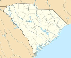 RBW Location of airport in South Carolina | |||||||||||||||||||
| Runways | |||||||||||||||||||
| |||||||||||||||||||
| Statistics (2011) | |||||||||||||||||||
| |||||||||||||||||||
Lowcountry Regional Airport (IATA: RBW, ICAO: KRBW, FAA LID: RBW) is a public use airport located two nautical miles (4 km) northeast of the central business district of Walterboro, a city in Colleton County, South Carolina, United States. It is owned by the city and county.[1] This airport is included in the National Plan of Integrated Airport Systems for 2011–2015, which categorized it as a general aviation facility.[2] It does not have scheduled commercial airline service.
History
The airport was dedicated June 15, 1933 as the C.C. Anderson Landing Field. In 1942 the United States Army Air Forces indicated a need for the airfield as a training airfield and control was turned over to the USAAF in February 1942. An immediate construction program began to turn the civil airport into a military airfield. Construction involved runways and airplane hangars, with three concrete runways, several taxiways and a large parking apron and a control tower. Several large hangars were also constructed. Buildings were ultimately utilitarian and quickly assembled. Most base buildings, not meant for long-term use, were constructed of temporary or semi-permanent materials. Although some hangars had steel frames and the occasional brick or tile brick building could be seen, most support buildings sat on concrete foundations but were of frame construction clad in little more than plywood and tarpaper. Walterboro Army Airfield was assigned to Third Air Force III Air Support Command, and activated on 1August 15, 1942. The 305th Air Base Group was the station host unit.
Initially Walterboro AAF was used primarily for training of B-25 Mitchell medium bomber pilots and aircrews, acting a sub-base of Columbia Army Airfield for follow-on training prior to the units being deployed to overseas combat theaters. Units assigned to the airfield during World War II were:
- 310th Bombardment Group (Medium), 11 August-18 September 1942
- 321st Bombardment Group (Medium), September 1942-18 December 1942
- 340th Bombardment Group (Medium), 30 November 1942 – 30 January 1943
- 345th Bombardment Group (Medium), 6 March-16 April 1943
- 405th Fighter-Bomber Group, 14 September 1943 – 14 September 1944, (A-24 Dauntless A-25 Shrike)
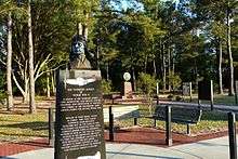
Walterboro AAF also hosted the largest camouflage school in the United States, as well as a 250-person Prisoner of War Camp. In 1944 it was reassigned to First Air Force and became an advanced combat training base for individual fighters, primarily the black trainees graduating from Tuskegee Army Air Field in Tuskegee, Alabama. Over 500 of the famed Tuskegee Airmen trained at Walterboro Army Air Field between April 1944 and October 1945 including individuals training as replacement pilots for the 332nd Fighter Squadron and the entire 447th Bombardment Group. A memorial has been erected at the site commemorating their service.
The base closed on October 31, 1945 and returned to its origins as a local airfield.
Facilities and aircraft
Lowcountry Regional Airport covers an area of 1,400 acres (567 ha) at an elevation of 101 feet (31 m) above mean sea level. It has three runways with asphalt/concrete surfaces: 5/23 is 6,002 by 100 feet (1,829 x 30 m); 17/35 is 5,705 by 100 feet (1,739 x 30 m); 9/27 is 5,408 by 100 feet (1,648 x 30 m).[1]
For the 12-month period ending November 9, 2011, the airport had 28,000 aircraft operations, an average of 76 per day: 98% general aviation and 2% military. At that time there were 22 aircraft based at this airport: 82% single-engine, 5% multi-engine, and 14% jet.[1]
See also
References
- 1 2 3 4 FAA Airport Master Record for RBW (Form 5010 PDF). Federal Aviation Administration. Effective April 5, 2012.
- ↑ "2011–2015 NPIAS Report, Appendix A" (PDF, 2.03 MB). National Plan of Integrated Airport Systems. Federal Aviation Administration. October 4, 2010. External link in
|work=(help)
-
 This article incorporates public domain material from the Air Force Historical Research Agency website http://www.afhra.af.mil/.
 - Manning, Thomas A. (2005), History of Air Education and Training Command, 1942-2002. Office of History and Research, Headquarters, AETC, Randolph AFB, Texas ASIN: B000NYX3PC
External links
- Aerial image as of January 1994 from USGS The National Map
- FAA Terminal Procedures for RBW, effective December 8, 2016
- Resources for this airport:
- FAA airport information for RBW
- AirNav airport information for KRBW
- ASN accident history for RBW
- FlightAware airport information and live flight tracker
- NOAA/NWS latest weather observations
- SkyVector aeronautical chart, Terminal Procedures
.jpg)
| Airfields |
| .svg.png) | |||||||||||||||||||||||||||||||
|---|---|---|---|---|---|---|---|---|---|---|---|---|---|---|---|---|---|---|---|---|---|---|---|---|---|---|---|---|---|---|---|---|---|
| Units |
| ||||||||||||||||||||||||||||||||