Lound, Suffolk
| Lound | |
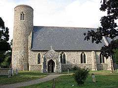 St John the Baptist's church at Lound |
|
 Lound |
|
| Population | 359 (2011)[1] |
|---|---|
| OS grid reference | TM505989 |
| Civil parish | Lound |
| District | Waveney |
| Shire county | Suffolk |
| Region | East |
| Country | England |
| Sovereign state | United Kingdom |
| Post town | LOWESTOFT |
| Postcode district | NR32 5 |
| Dialling code | 01502 |
| EU Parliament | East of England |
| UK Parliament | Waveney |
Coordinates: 52°31′48″N 1°41′31″E / 52.530°N 1.692°E
Lound is a village and civil parish in the north of the English county of Suffolk. It is in the Waveney district and part of the area known as Lothingland between Lowestoft and Great Yarmouth. Lound lies 4.5 miles (7.2 km) north of Lowestoft, 5 miles (8.0 km) south of Great Yarmouth and 2 miles (3.2 km) west of Hopton on Sea and the North Sea coast. The village lies just west of the main A12 dual carriageway between Great Yarmouth and Lowestoft.
The parish church is dedicated to St John the Baptist. It is a medieval round tower church dating from the 12th century and is a Grade II* listed building.[2]
The former Lothingland Middle School was located in the parish. This was closed in 2011 as part of reorganisation of schools in Suffolk by Suffolk County Council and will become part of the campus of Lowestoft College.[3]
Lound Lakes
Lound Lakes are a series of artificial lakes along the Norfolk-Suffolk border. They were originally formed by peat digging and are operated as a series of reservoirs by Essex and Suffolk Water.[4] The lakes, which include Fritton Lake to the west, drain into the River Waveney.[4] The area around the lakes is cared for by Suffolk Wildlife Trust as a 115 hectares (280 acres) nature reserve.[5] The site supports a range of habitats, including woodland, lowland grassland and fen as well as open water habitats.[5] Plant species such as floating bur-reed and water violet have been recorded, and the site is a roost for wildfowl such as barnacle goose, shoveler and gadwall.[5]
References
- ↑ Data view : Population - 5 year age bands - Persons - Census, Suffolk Observatory. Parish best estimates from United Kingdom Census 2011. Retrieved 2014-03-15.
- ↑ Church of St John the Baptist, Lound, British Listed Buildings. Retrieved 2014-03-15.
- ↑ Lowestoft College to take over Lothingland Middle School site, BBC news website, 2012-12-20. Retrieved 2014-03-15.
- 1 2 River Waveney, Fritton and Lound Lakes, Essex and Suffolk Water. Retrieved 2014-03-15.
- 1 2 3 Lound Lakes, Suffolk Wildlife Trust. Retrieved 2104-03-15.
| Wikimedia Commons has media related to Lound, Suffolk. |