Loughbrickland Crannóg
Coordinates: 54°18′25″N 6°17′49″W / 54.307°N 6.297°W
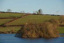
Loughbrickland Crannóg is a Bronze Age man-made island known as a crannóg, four miles (6.5 km) south west of Banbridge, County Down, Northern Ireland. It is situated in the middle of the lough, 1 mile from the village of Loughbrickland. The crannóg in Loughbrickland is a Scheduled Historic Monument in the townland of Drumnahare, in Banbridge District, at grid reference J1113 4118.[1] It is easily visible from the south-bound carriageway of the trunk A1 Belfast-Dublin route, just past the B3 Rathfriland exit.
Features
Loughbrickland Crannóg, set in the middle of the lake, was surrounded by a row of stakes and partly built up of occupation debris.[2]
History
The crannóg is a man-made island dating from around the Late Bronze Age period (from approx. 2000 to 500 BC).[3] It was later, in the 17th century, inhabited by the Magennis family, who had vacated a castle that is thought to have been located on the lake shore. It was the site of a 1642 skirmish in the Irish Rebellion when it was used as a hiding place by rebels.[3]
The Loughbrickland Community Association adopted an image of the crannóg as its logo and this appears on waymarks and signs along the Loughbrickland Historic Trail.[3]
References
- ↑ "Drumnahare" (PDF). Environment and Heritage Service NI - Scheduled Historic Monuments. Archived from the original (PDF) on November 5, 2008. Retrieved 2007-12-03.
- ↑ "Coolnacran Fort and Loughbrickland Crannóg". Banbridge District Online. Retrieved 2008-06-08.
- 1 2 3 "Loughbrickland Historic Trail". Walk Northern Ireland. Retrieved 2008-06-08.