Loch Na Fooey
| Loch Na Fooey Loch na Fuaiche | |
|---|---|
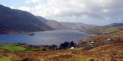 Viewed from Mayo on the R300 | |
| Location | County Galway |
| Coordinates | 53°34′40″N 9°32′53″W / 53.57778°N 9.54806°WCoordinates: 53°34′40″N 9°32′53″W / 53.57778°N 9.54806°W |
| Type | Glacial lake |
| Primary inflows | River Fooey |
| Primary outflows | Finny River |
| Basin countries | Ireland |
| Max. length | 2.5 mile |
| Max. width | 0.5 mile |
| Surface area | 2.56 km2 [1] |
| Surface elevation | 24 metres |
| Islands | Red Island (An tOileán Rua) |
| Settlements | Finny, Leenaun Clonbur/An Fháirche |
| References | [2][3] |
Loch Na Fooey (Irish: Loch na Fuaiche meaning 'Lake of the winnowing winds') or grave -shaped lake, is a rectangular shaped glacial lake situated in County Galway. Part of the north-eastern shore lies along the border to County Mayo. The closest village is Finny, County Mayo with the picturesque Galway village of Leenaun (and Ireland's only "fjord", Killary Harbour) approximately 11 km distant.
The picturesque village of Clonbur lies approximately 15km east of Lough na Fooey and between Ireland's largest lakes; Lough Corrib and Lough Mask.
Occasionally the lake may also be referred to as Loch Nafooey, or Lough Nafooey.
At approximately 2.5 miles long and 0.5 miles wide, Loch Na Fooey is set in a steep-sided valley, surrounded by the rugged mountains of Galway to the south and Mayo's Partry mountains (Sliabh Phartraí in Irish) to the north. A number of rivers feed the lake, including the River Fooey (in Irish Abhainn na Fuaiche), which rises from the Devil’s Mother mountain and enters the lake at the western shore. The Finny River, rising from the south-east of the lake drains into the southwest of part Lough Mask. Also many mountain streams flow into the lake. The lake has a small sandy shore on its western end.
The area around Loch Na Fooey is renowned as the site of the ancient "Finny volcano" (490 million years ago), formed as the Iapetus Ocean closed to bring the two halves of Ireland together. The volcano's landform is now gone but some of volcanic rocks are preserved in the area, including pillow lavas, and breccia.[4]
There is a small funnel-shaped island close to the south-eastern shore known as Red Island (An tOileán Rua)
The unpolluted waters hold a range of fish including wild brown trout and pike.
The locality offers many opportunities for walks, both for experienced hill walkers and for those who prefer something less challenging. The following high peaks in the locality all provide a good challenge: Bunacunneen, Devil's Mother, Leynabricka, Skeltia and Buckaun.
