Lough Foyle
| Lough Foyle/Loch Foyle Loch Feabhail | |
|---|---|
 Lough Foyle View From CarrickHugh Picnic Site | |
 | |
| Location | Republic of Ireland – United Kingdom border |
| Coordinates | 55°07′00″N 7°05′00″W / 55.116667°N 7.083333°WCoordinates: 55°07′00″N 7°05′00″W / 55.116667°N 7.083333°W |
| River sources | River Foyle, River Roe, River Faughan |
| Ocean/sea sources | Atlantic Ocean, Irish Sea |
| Basin countries |
Northern Ireland, Republic of Ireland |
| Settlements | Ballykelly, Derry, Greencastle, Magilligan, Moville, Muff |
| Designated | 2 February 1999 |
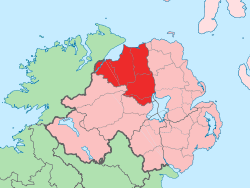
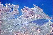
Lough Foyle, sometimes Loch Foyle[1] (from Irish: Loch Feabhail, meaning "Feabhal's loch"[2][3]), is the estuary of the River Foyle. It lies between County Londonderry in Northern Ireland and County Donegal in the Republic of Ireland. Sovereignty over these waters has been in dispute since the Partition of Ireland.
Ramsar site
The Lough Foyle Ramsar site (wetlands of international importance designated under the Ramsar Convention), is 2204.36 hectares in area, at latitude 55 05 24 N and longitude 07 01 37 W. It was designated a Ramsar site on 2 February 1999. The site consists of a large shallow sea lough which includes the estuaries of the rivers Foyle, Faughan and Roe. It contains extensive intertidal areas of mudflats and sandflats, salt marsh and associated brackish ditches. The site qualified under Criterion 1 of the Ramsar Convention because it is a particularly good representative example of a wetland complex which plays a substantial hydrological, biological and ecological system role in the natural functioning of a major river basin located in a trans-border position. It also qualified under Ramsar criterion 2 as it supports an appreciable number of rare, vulnerable or endangered species of plant and animal. A range of notable fish species have been recorded for the Lough Foyle estuary and the lower reaches of some of its tributary rivers. These include allis shad, twait shad, smelt and sea lamprey, all of which are Irish Red Data Book species. Important populations of Atlantic salmon migrate through the system to and from their spawning grounds.[4]
The site also qualified under Ramsar criterion 3 as it supports a large numbers of wintering waterfowl including internationally important populations of whooper swan, light-bellied brent goose and bar-tailed godwit, as well as wildfowl species which are nationally important in an all-Ireland context, including red-throated diver, great crested grebe, mute swan, Bewick's swan, greylag goose, shelduck, common teal, mallard, Eurasian wigeon, common eider, and red-breasted merganser. Nationally important wader species include Eurasian oystercatcher, Eurasian golden plover, grey plover, lapwing, red knot, dunlin, Eurasian curlew, common redshank and greenshank.[4]
Flora and fauna
Flora
A survey of Lough Foyle was made between March 1937 and June 1939 by H. Blackler.[5] In this a map shows the distribution of certain species of algae in the lough and a full annotated list of the algae recorded along with photographs of the different sites. The list included: Cyanophyceae, Chlorophyceae, Phaeophyceae, Rhodophyceae, lichens and two species of Zostera. The marine algae of Lough Foyle are also included in Morton (2003).[6]
Fauna
The Royal Society for the Protection of Birds has a reserve at the lough.[7]
Transport
In 1792 the four-mile Strabane Canal was constructed from the tidal waters of Lough Foyle at Leck, to Strabane. The canal fell into disuse in 1962. In June 2006 the Strabane Lifford Development Commission awarded a £1.3m cross-border waterways restoration contract. The project involves the restoration of one and a half miles of canal and two locks to working order. Work began on the Lough Foyle side of the canal in the summer of 2006 but by 2010 the partial restoration was deemed unsatisfactory and the local council refused to continue to maintain the canal. The Broharris Canal was constructed in the 1820s when a cut, some two miles long on the south shore of Lough Foyle near Ballykelly was made in the direction of Limavady. It served both as a drainage channel and a navigation with goods being brought from the Londonderry Port, and shellfish and kelp from the sand banks along the shore.
In the summer time, a ferry service operates between Greencastle and Magilligan across Lough Foyle.
Railway travel
Northern Ireland Railways runs from Londonderry railway station along the scenic shore of Lough Foyle, with views of Inishowen in County Donegal as well as the Atlantic Ocean via Coleraine to Belfast Central and Great Victoria Street. The strategically important Belfast-Derry railway line is to be upgraded to facilitate more frequent trains and improvements to the permanent way such as track and signalling to enable faster services.
From Londonderry railway station the next stop is Bellarena followed by Castlerock then Coleraine en route to Belfast. Walkers alighting from trains arriving at Castlerock can walk to Mussenden Temple owned by the National Trust and can see the mouth of Lough Foyle and Greencastle some distance away in County Donegal.
Literature
The main character of Alfred Bester's famous science-fiction novel, The Stars My Destination, is named Gulliver Foyle. Bester took the names of his characters from various locations in Ireland and Great Britain.
World War I
The United States Navy established a naval air station on 1 July 1918 to operate seaplanes during World War I. The base closed shortly after the First Armistice at Compiègne.[8]
World War II
At the end of World War II after the Allied victory, the remainder of the German Atlantic fleet of U-boats used to attack supply lines from America to Britain during the Battle of the Atlantic were assembled in Lough Foyle and scuttled, as part of Operation Deadlight.
Disputed status
Lough Foyle is a disputed territory between the Republic of Ireland and the UK; after the Partition of Ireland in 1922 each side claimed that it was in their own territory. Although this dispute is still ongoing there are currently no negotiations as to its ownership.
The UK's Foreign and Commonwealth Office (FCO) underlined its view on 2 June 2009 that all of Lough Foyle is in the United Kingdom, a spokesperson stating; 'The UK position is that the whole of Lough Foyle is within the UK. We recognise that the Irish Government does not accept this position...There are no negotiations currently in progress on this issue. The regulation of activities in the Lough is now the responsibility of the Loughs Agency, a cross-border body established under the Belfast Agreement of 1998.'[9]
In November 2016, the UK's Secretary of State for Northern Ireland reiterated the UK's view that all of Lough Foyle is in the UK,[10] whilst Ireland's Minister for Foreign Affairs stated that Ireland did not recognise Britain's claim to the entirety of Lough Foyle.[11]
See also
- List of loughs in Ireland
- List of Ramsar sites in Northern Ireland
- Wild Atlantic Way
- Partition of Ireland
References
- ↑ See Google Books for published examples online.
- ↑ Flanagan, Deirdre & Laurence; Irish Place Names, page 212. Gill & MacMillan, 2002. ISBN 0-7171-3396-6
- ↑ PlaceNames NI: Lough Foyle
- 1 2 "Designated and Proposed Ramsar sites in Northern Ireland" (PDF). Joint Nature Conservation Committee. Retrieved 7 July 2008.
- ↑ Blackler, H. 1951. An algal survey of Lough Foyle, Northern Ireland. Proc. R. Ir. Acad. 54B(6):97 – 139
- ↑ Morton, O. 2003. The marine macroalgae of County Donegal, Ireland.. Bull. Ir. biogeog. Soc.27: 3 – 164
- ↑ Royal Society for the Protection of Birds
- ↑ Van Wyen, Adrian O. (1969). Naval Aviation in World War I. Washington, D.C.: Chief of Naval Operations. p. 80.
- ↑ 3 June, 14:08:52 BST 2009. "Londonderry Sentiniel, Foyle 'loughed' in dispute – 3 June 2009". Londonderrysentinel.co.uk. Retrieved 4 April 2011.
- ↑ http://www.parliament.uk/business/publications/written-questions-answers-statements/written-questions-answers/?page=1&max=20&questiontype=AllQuestions&house=commons%2clords&uin=52620
- ↑ https://www.rte.ie/news/2016/1117/832423-lough-foyle/