Los Lagos Region
| Los Lagos Region X Región de Los Lagos | |||
|---|---|---|---|
| Region of Chile | |||
 | |||
| |||
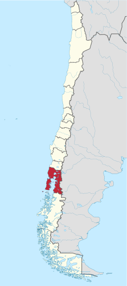 Map of Los Lagos Region | |||
| Coordinates: 41°28′18″S 72°56′12″W / 41.47167°S 72.93667°WCoordinates: 41°28′18″S 72°56′12″W / 41.47167°S 72.93667°W | |||
| Country |
| ||
| Capital | Puerto Montt | ||
| Provinces | Osorno, Llanquihue, Chiloé, Palena | ||
| Area[1] | |||
| • Total | 48,583.6 km2 (18,758.2 sq mi) | ||
| Area rank | 5 | ||
| Lowest elevation | 0 m (0 ft) | ||
| Population (2012 census)[1] | |||
| • Total | 767,714 | ||
| • Rank | 7 | ||
| • Density | 16/km2 (41/sq mi) | ||
| ISO 3166 code | CL-LL | ||
| Website | Official website (Spanish) | ||

Los Lagos Region (Spanish: X Región de Los Lagos, literally Region of the Lakes) is one of Chile's 15 regions, which are first order administrative divisions, and comprises four provinces: Chiloé, Llanquihue, Osorno and Palena. The region contains the country's second largest island, Chiloé, and the second largest lake, Llanquihue.
Its capital is Puerto Montt; other important cities include Osorno, Castro, Ancud, and Puerto Varas. The mainland portion of Los Lagos Region south of Reloncaví Sound (Palena Province) is considered part of Patagonia.
Los Lagos Region economy is dominated by the service sector but based in fishing, salmon aquaculture, forestry and cattle farming. Tourism is economically important in Andes where ski resorts, hot springs and recreational fishing are popular offers.
The region hosts Monte Verde, one of the oldest archaeological sites of the Americas. The largest indigenous group of the region are the Huilliche who lived in the area before the arrival of the Spanish. The Spanish crown settled Chiloé Archipelago in 1567[2] while the rest of the region begun to be slowly colonized by non-indigenous people only in late 18th century. In the 1850s Germans arrived to colonize the shores of Llanquihue Lake under a Chilean state-sponsored program.
Geography
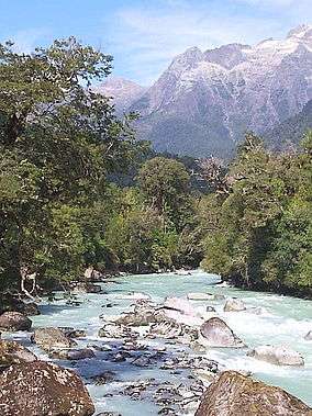
The region is bordered on the north by Los Ríos Region, on the south by Aisén Region, on the west by the Pacific Ocean and on the east by Argentina (provinces of Neuquén, Río Negro and Chubut). Wild environments can be seen along the coastal area, such as Caleta Zorra.
Demography
The region has an area of 48,585 km2 (18,759 sq mi) and its population, according to the 2002 INE Census was 1,243,000, with a population density of 25.6 /km² including Valdivia Province that in 2007 became a region of its own.
Climate
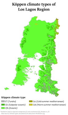
The region, in general, has a natural vegetation of Valdivian temperate rain forest. The coastal part, except for the south of the Chiloé Island, has a temperate climate with cold winter rain. To the south, the climate is characterized by constant rain and not having dry seasons.
Protected areas
Protected areas include 7 national parks, 2 private-owned parks and 2 natural monuments.
- National Parks
- Private parks
- Natural monuments
Transportation
El Tepual Airport lies a few miles west of Puerto Montt and Cañal Bajo Carlos Hott Siebert Airport a few miles east of Osorno. Also east of Osorno, the Cardenal Antonio Samoré Pass is a major mountain pass across the Andes to Argentina via Route 215.
 |
Los Ríos Region | Neuquén Province | | |
| Pacific Ocean | |
Chubut Province Río Negro Province | ||
| ||||
| | ||||
| Aysén Region |
See also
References
- 1 2 "Los Lagos Region". Government of Chile Foreign Investment Committee. Retrieved 13 March 2010.
- ↑ Hanisch, Walter. La Isla de Chiloé. 1982. p. 11-12.
External links
| Wikivoyage has a travel guide for Los Lagos. |
- http://www.frutillar.com (Spanish)
- http://www.regiondeloslagos.cl (Spanish)
- http://www.regionx.cl (Spanish)
- Satellite view of Puerto Montt (Google maps)
- Satellite view of the Chiloé archipielago (Google maps)
- Satellite view of Lake Llanquihue (Google maps)
- Satellite view of Osorno (Google maps)
- Satellite view of Valdivia (Google maps)
- Satellite view of Chaitén (Google maps)
