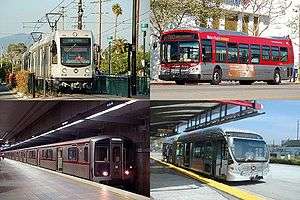
Los Angeles Metro Rail
 | |||
| Overview | |||
|---|---|---|---|
| Locale | Los Angeles County, California | ||
| Transit type |
Rapid transit (heavy rail and light rail) | ||
| Number of lines |
6 lines total[1]
| ||
| Line number |
| ||
| Number of stations | 93[1] | ||
| Daily ridership |
362,135 (July 2016; avg. weekday boardings)[2] | ||
| Website | Metro | ||
| Operation | |||
| Began operation | July 14, 1990[1][3] | ||
| Operator(s) | Los Angeles County Metropolitan Transportation Authority (Metro) | ||
| Headway | 4–8 mins (peak); 10–20 mins (off-peak) | ||
| Technical | |||
| System length | 105 mi (169.0 km)[1] | ||
| Track gauge |
4 ft 8 1⁄2 in (1,435 mm) (standard gauge) | ||
| Electrification | 750 V DC | ||
| |||
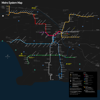
Metro Rail is an urban rail system serving Los Angeles County, California. It consists of six lines, including two rapid transit subway lines (the Red and Purple lines) and four light rail lines (the Blue, Green, Gold and Expo lines) serving 93 stations. It connects with the Metro Liner bus rapid transit system (the Orange Line and Silver Line) and also with the Metrolink commuter rail system. Metro Rail, which had an average daily weekday ridership of 362,135 as of July 2016,[4] is owned and operated by the Los Angeles County Metropolitan Transportation Authority (Metro) and started service in 1990. It has been extended significantly since that time and several further extensions are either in the works or being considered.
The Metro Rail system is the indirect descendant of Pacific Electric Red Car and Los Angeles Railway Yellow Car lines, which operated between the late 19th century and the 1960s, and utilizes many of their former rights-of-way.[5]
Current system
Lines
In Los Angeles Metro terminology, common with most other metro systems, a line is a named service, defined by a route and set of stations served by trains on that route. (The word does not refer to a physical rail corridor, as it does in New York City Subway nomenclature.) Metro Rail lines are named after colors (with the exception of the Expo Line), and these colors are used to distinguish the lines on Metro's maps. Metro also uses colors for its Metro Liner services (which are bus services operating in transitways). Some Metro Rail lines (in particular, the Crenshaw/LAX Line) have no colors assigned to them yet. There is currently a proposal to rename all metro rail and BRT lines with letters.[6] This proposal would be fully implemented after completion of the Regional Connector project, assigning letters in the order that the lines were, or will be, put into service.
Six Metro Rail lines operate in Los Angeles County:[1]
| Line name | Opening[1] | Length[1] | Stations[1] | Termini | Type |
|---|---|---|---|---|---|
| |
1990 | 22 mi (35 km) | 22 | 7th Street/Metro Center (north) Downtown Long Beach (south) |
Light rail |
| |
2012 | 15.2 mi (24.5 km) | 19 | 7th Street/Metro Center (east) Santa Monica (west) |
Light rail |
| |
2003 | 31 mi (50 km) | 27 | APU/Citrus College (north) Atlantic (south) |
Light rail |
| |
1995 | 20 mi (32 km) | 14 | Redondo Beach (west) Norwalk (east) |
Light rail |
| |
2006[lower-alpha 1] | 6.4 mi (10.3 km) | 8 | Wilshire/Western (west) Union Station (east) |
Heavy rail |
| |
1993 | 16.4 mi (26.4 km) | 14 | North Hollywood (north) Union Station (south) |
Heavy rail |
- ↑ The segments on which the Purple Line operates opened as part of the Red Line corridor in 1993 and 1996. The Purple Line was not defined as a distinct line until 2006.
The Red and Purple lines follow a fully underground route (subway), and the Green Line follows a fully elevated route. The Blue, Expo and Gold Line routes run in a mix of environments, including at-grade street running, at-grade ROW, elevated, and underground.[1]
The two heavy-rail lines (Red and Purple) share right-of-way between Union Station and Wilshire/Vermont, while two of the light-rail lines (Blue and Expo) share right-of-way between 7th St/Metro Center and Pico, since they use compatible technologies. Future system expansions are expected to use shared light-rail rights-of-way.
Stations
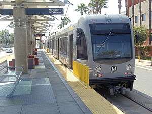
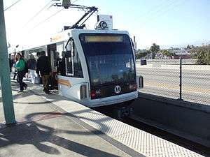
Stations include at least two ticket machines, wayfinding displays, electronic displays, and bench seating. Surface stations are designed with shade canopies. Many suburban stations also have free or reserved parking available and some have bike storage available. After many years lacking them, locking fare gates (turnstiles) have been phased in at all underground stations and many surface stations.
Most stations are unstaffed during regular hours. Call boxes are available at most stations to allow employees at the Metro Rail Operations Control Center to assist passengers with concerns.
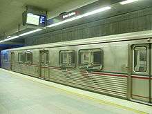
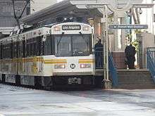
All street-level light rail stations feature platforms with segregation from nearby roads and sidewalks. All heavy rail stations have a mezzanine; the mezzanine is often heavily decorated with artwork while the platform level typically has a simple, functional design.
The large majority of light rail stations are either at ground level or elevated, while a handful are located underground. All heavy rail stations are located underground. Each station features unique artwork reflecting local culture and/or the function of transit in society. Subway stations and tunnels are designed to resist earthquakes of up to magnitude 7.5.
Wi-Fi and cellular phone service will be installed in stations and tunnels along the Metro Rail system as a $800,000 project. Coverage will be rolled out in phases, starting with portions of the Red and Purple lines, then later the Gold Line by March 2017.[7]
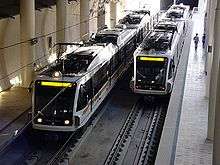
Rolling stock
Metro Rail maintains two distinct systems of rail: a light rail system and a heavy rail system. The heavy rail and light rail systems are incompatible with each other, even though they both use 4 ft 8 1⁄2 in (1,435 mm) standard gauge. Metro's heavy rail lines are powered by third rail, whereas its light rail lines are powered by overhead catenary. Also, the two separate systems have different loading gauge, and platforms are designed to match the separate car widths.
Hours of operation
All Metro Rail lines run regularly between 5am and midnight, seven days a week. Limited service on particular segments is provided after midnight and before 5am. On Friday and Saturday evenings, service operates until approximately 2am. There is no rail service between 2am and 3:30am, except on special occasions such as New Year's Eve. Service operates every 5–10 minutes during the peak period, every 10–15 minutes during middays and during the day on weekends, and every 20 minutes during the evening until the close of service. Exact times vary from route to route.
Fares and fare collection
The standard Metro base fare applies for all trips. Fare collection is based on a partial proof-of-payment system. At least two fare machines are located at each station. Fare inspectors and deputy sheriffs police the system and cite individuals without fares. Passengers are required to purchase a TAP card to enter stations equipped with fare gates. Passengers using a TAP card can transfer between Metro routes for free within 2 hours from the first tap.
The following table shows Metro fares, effective September 15, 2014 (in US dollars):
| Fare Type | Regular | Senior (62+)/ Disabled/ Medicare |
College/ Vocational |
Student K-12 |
|---|---|---|---|---|
| Base Fare | $1.75 | $0.35 (off-peak) $0.75 (peak) |
— | $1 |
| Tokens (bag of 10) | $17.50 | — | — | — |
| 1-Day Pass | $7 | $2.50 | — | — |
| 7-Day Pass | $25 | — | — | — |
| 30-Day Pass | $100 | $20 | $43 | $24 |
| Metro-to-Muni Transfer | $0.50 | $0.25 | — | — |
Transit Access Pass (TAP) and fare gates
Metro has implemented a system of electronic fare collection using a stored value smartcard called the Transit Access Pass (or TAP Card). This card was intended to simplify fare collection and reduce costs.[8] In 2012, paper monthly passes were phased out and replaced with the TAP Card. As of September 2013, first-time Metro riders must deposit an additional $2 (or $1 at TVMs) on top of their first fare payment in order to obtain a reloadable TAP Card.
In addition, Metro began installing fare gates in 2008, at all heavy rail stations, select light rail stations, and all future stations. Implementation of both programs (the TAP Card and the fare gate program) has turned out to be expensive ($154 million in total, so far) and its initial rollout was problematic.[9]
Ridership
As of the fourth quarter of 2014, the combined Metro Red and Purple lines averaged a weekday ridership of 153,000,[10] making it the ninth busiest heavy rail (rapid transit) system in the United States. Taking overall track length into consideration, Metro Rail's heavy rail lines transport 8,793 passengers per route mile, making this the fifth busiest system U.S. rapid transit system on a per mile basis. This is still a far lower per-mile ridership than the transit systems of New York City (New York City Subway and PATH), Boston (MBTA), and Philadelphia (SEPTA).
Metro's light rail system is the second busiest LRT system in the United States and largest in the Western United States and California by ridership, with 200,800 average weekday boardings during Q4 2014.[10] Additionally, the Blue Line is the second largest light rail line by ridership in the United States with an average weekday ridership of 89,646 in 2013,[11][12] after the Boston Green Line's daily ridership of 221,400 (in Q4 2013),[13] though the Boston Green Line has four outbound termini, so that its 23 miles (37 km) of route service a larger lateral area than the Blue Line's 22 miles (35 km), but over a shorter length.
Security and safety
Metro Rail's trains and stations are patrolled by the Los Angeles County Sheriff's Department,[14] and are monitored by security personnel via closed-circuit television cameras in Metro Rail stations and subway cars.[15]
History
Background
Over five decades Southern California had an extensive privately owned rail transit network with over 1,000 miles (1,600 km) of track – operated by Pacific Electric (Red Cars) and Los Angeles Railway (Yellow Cars). However, from 1927 revenue shortfall caused Pacific Electric to begin replacing lightly used rail lines with buses.
In World War II, the system briefly returned to profitability due to gas rationing and troop movement, but after the war Pacific Electric once again maintained an operating deficit and the rail system was slowly dismantled in what became known as the Great American streetcar scandal. In 1958 the remnants of the privately owned rail and bus systems were consolidated into a government agency known as the Los Angeles Metropolitan Transit Authority or MTA.
The final removal of the system continued, and by 1963 the remaining rail lines were completely removed and replaced with bus service. In the decades that followed, with growing traffic congestion, public support for the return of rail transit increased.
Planning
Beginning in the 1970s, a variety of factors, including environmental concerns, an increasing population and the price of gasoline led to calls for mass transit other than buses. In 1976, the State of California formed the Los Angeles County Transportation Commission to coordinate the SCRTD's efforts with those of various municipal transit systems in the area and to take over planning of countywide transportation systems. The SCRTD continued planning of the Metrorail Subway (the Red Line), while the LACTC developed plans for the light rail system. After decades, the wheels of government began to move forward, and construction began on the Los Angeles County Metro Rail system in 1985. In 1988, the two agencies formed a third entity under which all rail construction would be consolidated. In 1993, the SCRTD and the LACTC were finally merged into the Los Angeles County Metropolitan Transportation Authority (LACMTA, now branded as Metro).
The LACMTA began construction of the initial lines throughout the 1980s using revenues from a voter-approved increase in sales tax.
Expansions
The Blue Line finally opened on July 14, 1990, some 27 years after the final streetcar line closed. Since that date, the system has been developed to its current size. The following table shows the timeline of this expansion:
| Segment description | Date opened | Line(s) | Endpoints | # of new stations |
Length (miles) |
|---|---|---|---|---|---|
| Blue Line Initial Segment | July 14, 1990 | Blue | Pico to Anaheim Street | 17 | 19.1 |
| Blue Line Long Beach Loop | September 1, 1990 | Blue | Anaheim Street to Pacific | 4 | 2.2 |
| Blue Line To Financial District | February 15, 1991 | Blue | Pico to 7th St/Metro Center | 1 | 0.7 |
| Red Line MOS-1 | January 30, 1993 | Red, Purple[lower-alpha 1] | Union Station to Westlake/MacArthur Park | 4[lower-alpha 2] | 4.4 |
| Green Line | August 12, 1995 | Green | Redondo Beach to Norwalk | 13[lower-alpha 2] | 20.0 |
| Red Line MOS-2 West | July 13, 1996 | Red, Purple[lower-alpha 1] | Westlake/MacArthur Park to Wilshire/Western | 3 | 2.0 |
| Red Line MOS-2 North | June 12, 1999 | Red | Wilshire/Vermont to Hollywood/Vine | 5 | 4.7 |
| Red Line MOS-3 | June 24, 2000 | Red | Hollywood/Vine to North Hollywood | 3 | 6.3 |
| Gold Line Initial Segment | July 26, 2003 | Gold | Union Station to Sierra Madre Villa | 12[lower-alpha 2] | 13.7 |
| Gold Line Eastside Extension | November 15, 2009 | Gold | Union Station to Atlantic | 8 | 6.0 |
| Expo Line Initial Segment | April 28, 2012 | Expo | Flower/Washington to La Cienega/Jefferson[lower-alpha 3] | 8 | 7.6 |
| Expo Line Culver City Extension | June 20, 2012 | Expo | La Cienega/Jefferson to Culver City | 2[lower-alpha 4] | 1.0 |
| Gold Line Foothill Extension | March 5, 2016[16] | Gold | Sierra Madre Villa to APU/Citrus College | 6[16] | 11.5[16] |
| Expo Line Santa Monica Extension | May 20, 2016[17] | Expo | Culver City to Santa Monica | 7[17] | 6.6[17] |
| TOTAL | 93 | 105.8[lower-alpha 5] |
- 1 2 Segment opened as part of the Red Line corridor. The Purple Line was not defined as a distinct line until 2006.
- 1 2 3 Segment also included significant expansion of an existing station: this was not counted as a new station.
- ↑ In terms of added trackage; Expo Line has thru service to 7th St/ Metro Center.
- ↑ Expansion included new infill station.
- ↑ Likely varies from the "official" Metro figure due to rounding differences.
Future
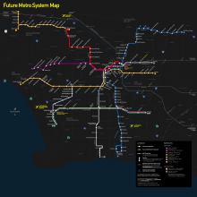
Metro has worked over the past several years to plan and prioritize project funding and implementation. Metro's 2009 Long Range Transportation Plan (LRTP) was developed to provide a long-term vision of transportation system development for the next 30 years.[18] Measure R, a countywide incrememental sales tax increase passed by voters in 2008, provides funding for many of the highest priority projects in the LRTP.[19] Measure J, a proposed extension of the Measure R sales tax for an additional 30 years that would have allowed for acceleration of the construction timeline for many of the LRTP projects appeared on the November, 6th 2012 ballot in Los Angeles County.[20] However, Measure J did not succeed, garnering 66.11% of the vote, just short of the ⅔ majority needed to pass. The result has prompted some to reconsider the utility of a ⅔ vote threshold for passage of transit taxes.[21][22] In 2015, Metro contemplated renaming its light rail lines using a letter-based scheme,[23][24] but has not adopted the proposal as of November 2016.
In November 2016, voters approved Measure M, a half-cent sales tax increase to fund transportation projects, including Metro Rail expansion.[25]
Current and priority projects
The following rail projects have been given high priority by Metro. They all appear in the 2009 LRTP constrained plan,[18] and all have funding earmarked from Measure R.[19][26] With the passage of Measure M in 2016, Metro plans to release an updated Long Range Transportation plan in 2017.[18]
| Concept Name | Description | Construction | Operational | Status |
|---|---|---|---|---|
| Crenshaw/LAX Line[27] | Creates a new light-rail route to be used by the Crenshaw/LAX Line, starting at a new light rail subway station near the current Crenshaw/Expo station on Crenshaw Blvd. (Metro Expo Line) and connecting to the Metro Green Line corridor near the current Aviation/LAX station. | 2010–12 | 2019 | Under construction |
| Regional Connector[28] | Creates a new light rail subway route through Downtown Los Angeles, linking the Metro Blue Line, Gold Line and Expo Line. | 2014–16 | 2020[28] | Under construction[29] |
| Purple Line Extension Phase 1[30][31] | Extends the Metro Purple Line west along Wilshire Blvd to La Cienega Blvd (with fully approved plans to later extend the line to Westwood). Extensions as far as Westwood are included under Measure R. Further extensions west from Century City to Westwood are included as a Tier 1 Strategic Unfunded Plan project in Metro's 2009 Long Range Transportation Plan,[32] meaning they would require new funding sources. | 2013–15 | 2023 | Under construction[33] |
| East San Fernando Valley Transit Corridor[34] | Light rail, streetcar, or BRT line, connecting the east San Fernando Valley to the Metro Orange Line, largely along Van Nuys Blvd and San Fernando Road. The Sepulveda Pass transit corridor is immediately to the south of Van Nuys Blvd corridor; if a rail alternative is selected for both corridors, they may eventually be merged into one route. | 2013–15 | 2018(?) | Draft EIR in progress |
| Gold Line Eastside Phase 2 Corridor[35] | Extends the Metro Gold Line from its current Eastside terminus eastward. Two routes - either along Washington Boulevard to Whittier or along SR-60 to South El Monte - are under consideration. Metro directors have expressed interest in building both routes if funding becomes available, either as branches or with one route connecting to the Gold Line and the other to the planned West Santa Ana Branch line. | 2025 | 2035 | Draft EIR published |
| South Bay Green Line Extension[36] | Extends the Metro Green Line from its current terminus in Redondo Beach toward the South Bay and Torrance. | 2026 | 2035 | Draft EIR in progress |
| Airport Metro Connector[37] | In cooperation with Los Angeles World Airports (LAWA), connects LAX to the L.A. Metro Rail system, through the construction anautomated people mover system through an infill ight rail station, via the Metro Crenshaw/LAX Line to connect to LAX Terminals 1-8 and car rental center. | 2010–12 | 2024 | Draft EIR preparation to begin in Q1 2015 |
| West Santa Ana Branch Corridor[38][39] | Creates a new rail or bus rapid transit route connecting the Gateway Cities to Orange County. Metro staff have floated the possibility of connecting the corridor to either Whittier via Washington Boulevard or South El Monte via SR-60, whichever is not chosen for the Gold Line Eastside Extension Phase 2. Early plans for the corridor also included connecting it to a line to Burbank. | 2017 | 2024 | Alternatives analysis in progress[38] |
| Sepulveda Pass Transit Corridor[40] | Freeway project added a 10-mile HOV lane and improved supporting infrastructure such as ramps, bridges and sound walls on the San Diego Fwy. (I-405); later option to add a heavy rail or light rail route connecting the west San Fernando Valley to the Westside. If a rail option is chosen, it could merge into the Van Nuys Boulevard (East SFV) Corridor to San Fernando Metrolink in the north, and could reach Westwood and eventually LAX in the south. Additional funding, either from taxes or a public-private partnership, is likely required due to the high cost of tunneling through the mountains, according to Metro reports. | 2028 | 2039 | Alternatives analysis in progress |
Other expansion concepts
The following proposed line/system expansions do not currently have funding or high priority in Metro's long-range plans. Some are listed as "strategic unfunded" in the last Long Range Transportation Plan, indicating some possibility they could be constructed should additional funding materialize. Others have been the subject of Metro Board discussion, with the possibility of future feasibility studies. (More information on each project can be found in the references.)
Note that a major update of Metro plans is underway, with a view to seeking additional funding via a ballot measure and updating the Long Range Transportation Plan. The results of early planning studies as a part of that process are expected to be made public in approximately February 2015, and may result in the addition of new proposed projects, changes to concepts listed below, and the removal of concepts whose popularity has declined since 2009.
| Concept Name | Description | Source |
|---|---|---|
| Pink Line (Originally HRT) | Create a new LRT line connecting the Metro Red Line's Hollywood/Highland station to the Metro Purple Line, via Santa Monica Boulevard and West Hollywood. Possible future extension south of Wilshire on San Vicente Boulevard, connecting to a future Crenshaw Line that would run north of Exposition Boulevard. Routes including Fairfax, La Brea, and La Cienega have been floated in Metro planning documents. An extension of the Crenshaw Line is included as a Tier 1 Strategic Unfunded Plan project in the 2009 Long Range Transportation Plan.[32] | Metro's Westside Subway Extension meetings.[30] |
| Gold Line Ontario Extension | Further extend the Metro Gold Line eastward to L.A./Ontario International Airport, via Upland. Because Ontario is across the county line in San Bernardino County, extensions beyond Claremont would require San Bernardino County funding and changes to Metro's powers under state legislation. Further eastward extensions of the Gold Line are included as a Tier 1 Strategic Unfunded Plan project (though with "first priority" for funding in Tier 1) in the 2009 Long Range Transportation Plan.[32] | Metro Gold Line Foothill Construction Authority,[41] GoldLine2Ontario.com[42] |
| Red Line Eastern Extension | Extend the Metro Red Line (or Purple Line) from eastern terminus, south along the river to either Arts District or the future "Cleantech" corridor, and possibly across the river along Whittier Blvd. to the Eastside. Considered unlikely after decision to serve some of these areas with the Gold Line Eastside extension, and not included in 2009 Long Range Transportation Plan.[43] However, Metro is studying the possibility of adding one or two stops along the river in the Arts District as part of a project to improve and expand the rail yard already in the area to accommodate increased headways once the Purple Line extension is completed.[44] | |
| Burbank-Glendale Line | Would connect Downtown Los Angeles to Glendale and Burbank. Studied in the 1990s, and included as a Tier 1 Strategic Unfunded Plan project in 2009 Long Range Transportation Plan.[32] | |
| Red Line To Burbank Airport | Extend the Metro Red Line 3.2 miles (5.1 km) from its northwestern terminus to Burbank Airport. Included as a Tier 2 Strategic Unfunded Plan project in 2009 Long Range Transportation Plan.[32] | |
| Lincoln Blvd Line | Extend the Green Line northwest to Westchester, Marina Del Rey or Santa Monica. The Green Line was originally engineered to maintain compatibility with this extension, and includes a wye near LAX to connect to this. Included in City of Los Angeles Westside Mobility Plan, and as a Tier 2 Strategic Unfunded Plan project in 2009 Long Range Transportation Plan.[32] | |
| Green Line To Norwalk Metrolink | Extend the Green Line east to Norwalk/Santa Fe Springs station (Metrolink). Included as a Tier 1 Strategic Unfunded Plan project in 2009 Long Range Transportation Plan.[32] | [45] |
| Vermont Corridor Subway | Create a new subway down Vermont Avenue, connecting the Metro Red Line and Purple Line to the Metro Expo Line and Green Line. Included as a Tier 2 Strategic Unfunded Plan project in 2009 Long Range Transportation Plan;[32] a Bus Rapid Transit line is planned for the corridor in the meantime. | |
| "Silver Line" (former name) | New light-rail line planned to connect El Monte to Hollywood, via Valley Blvd corridor and Santa Monica Boulevard. Included as a Tier 2 Strategic Unfunded Plan project in 2009 Long Range Transportation Plan.[32] | Silver Line website (archived),[46] The Transit Coalition website.[47] |
| NoHo/Burbank-Pasadena Corridor (or State Route 134 Corridor) | Mentioned as potential subject for study in recent Metro Board motions. Included as a Tier 2 Strategic Unfunded Plan project in 2009 Long Range Transportation Plan;[32] a Bus Rapid Transit line is planned for the corridor in the meantime. | |
| Yellow Line (North Hollywood to Downtown) | Citizen proposal to reuse the former Pacific Electric "Belmont Tunnel" into downtown. The portal and tunnel are currently obstructed in multiple locations. Listed as one of several Tier 2 Strategic Unfunded Plan project in the 2009 Long Range Transportation Plan.[32] | |
| Harbor Line | Light rail line to connect harbor area (San Pedro) to Metro Blue Line or Green Line. Floated in LA City Council motions and Metro Harbor Subdivision studies. A further southward extension to the Green Line is included as a Tier 1 Strategic Unfunded Plan project in the 2009 Long Range Transportation Plan.[32] | Citizens for a Harbor Line (blog)[48] |
| Orange Line LRT Conversion | Converting the current BRT line to LRT for some or all of its length. Made possible after the 2014 repeal of state legislation prohibiting LRT along the Orange Line right of way, which had been enacted due to neighborhood opposition in the 1990s.[49] Bridges along the busway are designed to LRT standards, but the project would require substantial service disruption as the roadway is replaced by rails and catenary wire installed. Some Valley politicians and pressure groups have endorsed the proposal; critics have suggested that funding would be better spent on adding new lines along other corridors in the Valley. | |
| LAX Express | Limited stop line connecting Union Station to Los Angeles International Airport, mainly via rail right-of-way along Slauson Avenue. Studied as part of the Harbor Subdivision Study. A greenway along Slauson, currently under study, would use the right of way and thus make construction of this project unlikely. | |
| Get LA Moving | Detailed unofficial comprehensive plan of regional mass transit, including new lines and extensions to existing lines. | Get L.A. Moving Plan[50] |
| MoveLA Measure R2 Plan | Discussion draft of possible funding under a new ballot measure, issued by MoveLA in 2014. Includes many of the above proposals, including: converting the Orange Line to Light Rail between North Hollywood and Warner Center; a Sepulveda Pass line from Sylmar to LAX; a South Bay extension of the Green Line along the Harbor Subdivision through Wilmington to connect to the Blue Line in Long Beach; a Gold Line Foothills Extension all the way to the San Bernardino County line; a Crenshaw line extension to Wilshire, West Hollywood, and Hollywood; a West Santa Ana Branch Line between Downtown Los Angeles and the Orange County line; a Purple Line extension to Santa Monica; a second branch of the Eastside Gold Line Phase 2 to whichever of Whittier or South El Monte is not chosen for Measure R funding; a Green Line extension to Norwalk Metrolink; a Red Line extension to Burbank airport; a Downtown LA-Burbank line; and a Burbank-Pasadena line. |
See also
- Los Angeles County Metropolitan Transportation Authority
- Los Angeles Metro Rail rolling stock
- Breda A-650 Metro Red Line Railcar
- Transportation in Los Angeles
- Measure R
- List of metro systems
- List of tram and light rail transit systems
- List of United States rapid transit systems by ridership
- List of United States light rail systems by ridership
References
- 1 2 3 4 5 6 7 8 9 "Facts At A Glance". Metro. January 16, 2015. Retrieved 2016-03-11.
- ↑
- ↑ "20 Years of Metro Rail". Metro. 2010. Retrieved 2014-12-05.
- ↑ "Ridership Statistics". Metro. 2016. Retrieved 2016-11-27.
- ↑ Taplin, Michael (1991). "City of the Automobile: Los Angeles looks to Light Rail London". Light Rail Review 2. Platform 5 Publishing/Light Rail Transit Association. pp. 27–30. ISBN 1-872524-23-0.
- ↑ "Letter Designations for Fixed Guideway Lines" (pdf). Metro. April 2015. Retrieved 2015-04-04.
- ↑ Scauzillo, Steve (January 17, 2015). "Red Line subway riders in L.A. to get WiFi, cell phone service". Los Angeles Daily News. Retrieved 7 June 2015.
- ↑ "Fares". Metro. Retrieved 2010-09-30.
- ↑ "MTA's $46M system of locking turnstiles sits unused, waiting for fare cards to be adopted - LA Daily News". Dailynews.com. August 21, 2010. Retrieved 2010-09-30.
- 1 2 "Transit Ridership Report Fourth Quarter and End-of-Year 2014" (pdf). American Public Transportation Association (APTA). March 3, 2015. Retrieved 2015-04-05 – via http://www.apta.com/resources/statistics/Pages/ridershipreport.aspx.
- ↑ "Metro Ridership - Rail". Service Performance Analysis, Metro. Retrieved 2015-04-05 – via https://www.metro.net/news/pages/ridership-statistics/.
- ↑ "Monthly Ridership Plot" (pdf). Service Performance Analysis, Metro. March 2015. Retrieved 2015-04-05.
- ↑ "Public Transportation Ridership Report Fourth Quarter 2013" (pdf). American Public Transportation Association (APTA). February 26, 2014. Retrieved 2015-04-05 – via http://www.apta.com/resources/statistics/Pages/ridershipreport.aspx.
- ↑ "Security". Metro.net. July 23, 2009. Retrieved 2010-09-30.
- ↑ "Riders with Other Forms of Transport Switching to Metro". www.metro.net. September 13, 2006. Retrieved 2013-05-15.
- 1 2 3 Nelson, Laura (March 5, 2016). "San Gabriel commuters cheer as Gold Line rail extension officially opens". Los Angeles Times. Retrieved 2016-03-06.
- 1 2 3 Hymon, Steve (February 25, 2016). "17 things to know about Expo 2 opening on May 20". The Source. Metro. Retrieved 2016-05-21.
- 1 2 3 "Long Range Transportation Plan". Metro. Retrieved 2016-11-12.
- 1 2 "Measure R". Metro. Retrieved 2010-09-30.
- ↑ "Measure J". Metro. Retrieved 2012-10-21.
- ↑ "Measure J Fails". County of Los Angeles Registrar-Recorder. Retrieved 2013-01-12.
- ↑ "Transit Backers Seek to Change State Law". Los Angeles Times. December 4, 2012. Retrieved 2013-01-12.
- ↑ Steve Hymon (April 7, 2015). "PowerPoint: Metro staff proposal to rename rail and BRT lines". The Source. Metro.
- ↑ "LA Metro Could Switch Rail Line Names From Colors To Letters". Curbed Los Angeles. Curbed Staff. April 3, 2015.
- ↑ Nelson, Laura J. (June 23, 2016). "Metro puts half-cent sales tax increase for transportation projects on November ballot". Los Angeles Times. Retrieved October 4, 2016.
- ↑ "Transit Program - Project Management - Project Budget and Schedule Status" (pdf). Metro. June 19, 2014. Retrieved 2014-08-16.
- ↑ "Crenshaw/LAX Transit Corridor". Metro. March 4, 2014. Retrieved 2014-07-29.
- 1 2 "Regional Connector Transit Corridor". Metro. May 20, 2014. Retrieved 2014-07-27.
- ↑ Steve Hymon (September 30, 2014). "Ground is broken for Regional Connector project to link Blue, Expo and Gold Lines". The Source. Metro. Retrieved 2014-11-19.
- 1 2 "Purple Line Extension (project website)". Metro. February 11, 2014. Retrieved 2014-07-29.
- ↑ "Summer 2013 - General Fact Sheet - Purple Line Extension" (pdf). Metro. Retrieved 2013-07-25.
- 1 2 3 4 5 6 7 8 9 10 11 12 "2009 Long Range Transportation Plan" (pdf). Los Angeles County Metropolitan Transportation Authority (Metro). 2010. p. 31. Retrieved 2016-01-09.
- ↑ Dave Sotero (November 10, 2014). "Long wait over: groundbreaking held for Wilshire Boulevard subway extension". The Source. Metro. Retrieved 2014-11-19.
- ↑ "East San Fernando Valley Transit Corridor". Metro. July 8, 2014. Retrieved 2014-08-16.
- ↑ "Eastside Transit Corridor Phase 2". Metro. May 6, 2014. Retrieved 2014-08-16.
- ↑ "South Bay Metro Green Line Extension". Metro. March 24, 2014. Retrieved 2014-08-16.
- ↑ "Airport Metro Connector". Metro. Retrieved 2014-11-19.
- 1 2 "West Santa Ana Transit Corridor". Metro. March 6, 2014. Retrieved 2014-08-16.
- ↑ "Home". pacificelectriccorridor.com. Retrieved 2010-09-30.
- ↑ "Sepulveda Pass Corridor". Metro. Retrieved 2014-08-16.
- ↑ "Metro Gold Line Foothill Extension Construction Authority (project website)". Metro Gold Line Foothill Extension Construction Authority. Retrieved 2013-07-24.
- ↑ "Serv-U from RhinoSoft.com". Goldline2ontario.com. Retrieved 2010-09-30.
- ↑ "Los Angeles Downtown News and Information". Ladowntownnews.com. May 27, 2010. Retrieved 2010-09-30.
- ↑ Nelson, Laura J. (March 18, 2015). "Metro could expand subway service to the downtown L.A. Arts District". Los Angeles Times. Retrieved 2015-05-28.
- ↑ Weikel, Dan (January 10, 2016). "Closing 2.8-mile transit gap in Norwalk could smooth regional commute". Los Angeles Times. Retrieved 2016-01-19.
- ↑ "METRO SILVER LINE -- Los Angeles Light Rail Trains from El Monte to Silver Lake // Silverline, Mass Transit". metrosilverline.com. Archived from the original on 2005-10-29.
- ↑ "The National Transit Coalition". thetransitcoalition.us.
- ↑ "harborline". harborline.blogspot.com.
- ↑ Steve Hymon (July 9, 2014). "Transportation headlines, Wednesday, July 9". The Source. Metro. Retrieved 2016-01-19.
- ↑ "Get L.A. Moving". fminus.com.
External links
![]() Media related to LACMTA Metro Rail at Wikimedia Commons
Media related to LACMTA Metro Rail at Wikimedia Commons
- Official website
- History of the Metro Rail System
- Network map (to-scale)
- Google map of Metro Rail/Busway stations
| Services |
|  | ||||||||||||||||
|---|---|---|---|---|---|---|---|---|---|---|---|---|---|---|---|---|---|---|
| Facilities and stations | ||||||||||||||||||
| Capital projects | ||||||||||||||||||
| Fleet | ||||||||||||||||||
| Other information | ||||||||||||||||||
| Common carriers |  | |
|---|---|---|
| Passenger carriers | ||
| Private carriers | ||
| Former carriers | ||
See also: List of United States railroads by political division | ||