Lookout Mountain
| Lookout Mountain-High Point | |
|---|---|
 A view of the apex of Lookout Mountain | |
| Highest point | |
| Elevation | 2,389 ft (728 m) NAVD 88[1] |
| Listing | Highest point in Walker County[2] |
| Coordinates | 34°51′49″N 85°23′33″W / 34.863712778°N 85.392452703°WCoordinates: 34°51′49″N 85°23′33″W / 34.863712778°N 85.392452703°W [1] |
| Geography | |
 High Point | |
| Parent range | Cumberland Plateau |
| Topo map | USGS Durham |
Lookout Mountain is a mountain ridge located at the northwest corner of the U.S. state of Georgia, the northeast corner of Alabama, and along the Tennessee state line in Chattanooga. Lookout Mountain was the scene of the "Last Battle of the Cherokees" during the Nickajack Expedition, which took place in the 18th century, as well as the November 24, 1863 Battle of Lookout Mountain during the American Civil War.
Origins
The name "Lookout Mountain" is said to have come from General Andrew Jackson's troops, but more likely comes from the Cherokee term for "two mountains looking at each other".[3]
Geography
Northern and eastern slopes and summit
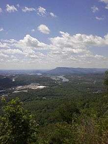
Lookout Mountain and Sand Mountain (to the southwest) make up a large portion of the southernmost end of the Cumberland Plateau. The area was lifted from an ancient sea, and worn down by erosion for millions of years. The summit, called "High Point", is located just east of Thompsonville in Walker County, Georgia, with an elevation of 2,392 feet (729 m) above sea level. The foothills of the mountain extend into Chickamauga and Chattanooga National Military Park.
The caves of Ruby Falls are in Lookout Mountain, and the rock formations of the "City of Rocks" (or Rock City) attraction are situated on the ridge. The area is home to the Lookout Mountain Incline Railway, Covenant College, and a hang-gliding school. Lookout Mountain is one of the Chattanooga area's most visited tourist attractions. Civil War-related landmarks include "Point Park", operated by the National Park Service, and the Cravens House. Nearby are Georgia's Cloudland Canyon and Cloudland Canyon State Park.
Southern and western slopes
The southwestern section of Lookout Mountain is in Alabama. The Little River, in Little River Canyon on the mountain, is the only river that begins and ends entirely on top of a mountain. The river flows over the DeSoto Falls in DeSoto State Park. The Noccalula Falls Park, featuring a pioneer village showcasing several nineteenth-century homes, is located at the southern terminus of Lookout Mountain, near Gadsden, Alabama. Local legend claims that the 90-foot falls' namesake, Noccalula, jumped to her death because she could not marry the man she loved.
White water sports and rock-climbing (offering views of the Coosa River Basin) are this area's key attractions.
Seven states

From the "Rock City" point, a marker claims that seven U.S. states could be seen: Tennessee, Kentucky, Virginia, South Carolina, North Carolina, Georgia and Alabama. The claim is repeated on numerous barn roofs in the surrounding area. No scientific investigation has upheld this claim.
Sunset Rock
Located on the northwest side of Lookout Mountain, Sunset Rock is a popular trailhead and tourist stop. It is part of the Chickamauga and Chattanooga Military State Park, the largest and oldest Civil War national park.[4][5] Once known as Point Lookout, Sunset Rock provides a view of the Tennessee River, Signal Mountain and Prentice Cooper State Forest.[6][7] The 100-foot cliff and moderate temperatures invite heavy traffic for its many climbing routes, which were completed in 1960. Sunset Rock is mainly sandstone; making for easier routing and climbing. Route development continued through the 1960s and 1970s. In the 1980s, routers pushed the grades ever higher. Climbing here is especially popular in the autumn months due to cooler weather.[8]
Sunset Rock is attractive to Civil War enthusiasts due to its history; it has a Tennessee Historical Commission Marker at the head of the trail, describing its Civil War battle history. Confederate Generals Braxton Bragg and James Longstreet [9] used Sunset Rock as a lookout in 1863 where they were able to track the movement of the Union troops as they entered Lookout Valley. It is claimed that unknown to Longstreet, the Union troops could see him on Sunset Rock from the valley, where they were able to decipher the Confederate code, giving them the ability to anticipate the next moves of the Confederates.[10] This resulted in the Battle of Wauhatchie, in which the Confederate army attempted to remove the Union forces from the river and block their supply lines. The attempt was unsuccessful; with the consequence that the Union forces were able to lay siege to Chattanooga.
History
Native Americans and Lookout Mountain
A branch of Cherokee Native Americans lived in Chattanooga, the Chickamauga people. The Chickamauga called the mountain Chat-a-nu-ga; hence the name of the city. Research suggests the mountain was inhabited, although no physical evidence has been found. On top of the mountain, the pattern of boulders suggest lanes or walls were once there.[11]
Revolutionary War and aftermath
Legend has it that during the Revolutionary War, a battle, between the forces of John Sevier and those of Chief Dragging Canoe of the Chickamauga Cherokee, took place on Lookout Mountain. Archaeologist and ethno-historian, Raymond Evans, has asserted that such a battle could not have taken place.[12] However, a battle between Sevier's militia forces from the State of Franklin and those of Dragging Canoe did occur there in August 1788.[13]
Settlements
It was reported that on August 28, 1823, Daniel S. Butrick and William Chamberlain arrived at Lookout Mountain to perform missionary work with Native Americans. After the Trail of Tears, land taken from the tribes was purchased by the highest bidder without a lottery of land parcels. This method of distributing land caused much of Lookout Mountain to be owned by a few wealthy Chattanooga families.
The aptly named Summertown, located on top of the mountain, was barely accessible from a small rutted turnpike which had been built in 1852 by Colonel James A. Whiteside. Whiteside, a native of Danville, Kentucky, owned a summer home which he converted into a hotel with several cottages. Naturalists who came to the area and visited the summit, such as Bradford Torrey, thought the cottages spoiled the environment and made it look like a cheap resort. Whiteside had purchased much of the land on the mountain’s summit. Another wealthy Chattanoogan, Robert Cravens, had purchased most of the land on the side of the mountain. Cravens was also instrumental in developing the area, and moved into the house he built (the Cravens House) in 1855. Within a few years, about 25 families regularly summered on the mountain.
Lookout Mountain's Sunset Rock was once the home to the photo shop of JB Linn.[14] After the Union forces under Major General Joseph Hooker took over the mountain, Linn gained access to Sunset Rock (then called Point Lookout). He built a small shack there and named it "Gallery Point Lookout". In December 1863, he and his brother began taking photographs of many war commanders and officers, as well as wealthy civilians in the area. They became very successful with these pictures. The Gallery Point Lookout House is no longer in existence, but many of Linn’s photographs still exist.
Civil War
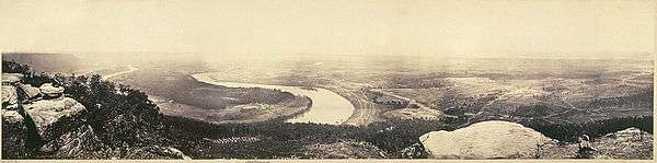
On November 24, 1863 the Battle of Lookout Mountain was fought on the slopes of the mountain. The majority of hand-to-hand combat took place near Cravens' house (about halfway to the summit). Lookout Mountain’s shape and location can in some conditions cause a unique weather phenomenon in the area: after dawn, fog will sometimes descend from the cooler mountaintop and stop about halfway down. Such an event took place the day of the battle and is the reason for its romanticized name, the "Battle Above the Clouds." The battle was won by Union forces, enabling them to lift the Confederate siege of Chattanooga.
Post Civil War
Yellow Fever Epidemic
When cases of Yellow fever began to increase in the United States, the Chattanooga population believed that the city was immune to any possibility of an epidemic because of its mountain climate. In 1878, the death of two individuals from the disease encouraged a widespread panic, causing an estimated 12,000 individuals to leave the city. A large percentage of this group went up the mountain, believing the climate would offer some protection against the disease. After the epidemic passed, many people complained about the inconvenient and complicated travel up the mountain, and the St. Elmo Turnpike (Ochs Highway) was created to help with access to the mountain.[15] Early in the 1900s, Lookout Mountain was incorporated as a town.
Twentieth century tourist boom
.jpg)
Entrepreneurs began marketing their own attractions in the 1910s and 1920s. Instead of serving just as a resort area for the wealthy, rich businessmen settled permanently on the mountain. Garnet Carter, J. B. Pound, O. B. Andrews, and Leo Lambert were a few of the more successful entrepreneurs who created their own attractions. Instead of making their money off of the tourist's room, board, or transportation, the area's natural attractions were enhanced. Sites that had long been popular (such as the 'City of Rocks", Lookout Mountain Cave –closed to the public since 1935– and the Lookout Mountain Incline Railway), were bought, “highly developed”, and marketed. The popular Ruby Falls Cavern has been a tourism mainstay for 80 years.
Today, tourist attractions include:
- Rock City- has multiple different events that occur over the course of the year and rock trails. These rock trails include Lover's Leap, Balanced Rock and Fat Man's Squeeze.
- Battle of Chattanooga Museum- The Museum offers insight of the Battle of Lookout Mountain through soldier figurines and topographical maps.
- Ruby Falls—view the waterfall from inside the mountain and Lookout Mountain Cave.
- Incline Railway—a National Historic site; the incline is 72.7%[16]
- Fairyland Caverns—underground cave which displays fairy-tale creatures and a castle.
References
- 1 2 "High Point 2 Reset". NGS data sheet. U.S. National Geodetic Survey. Retrieved 2011-06-07.
- ↑ "Lookout Mountain-High Point, Georgia". Peakbagger.com. Retrieved 2011-06-07.
- ↑ "Walker County". Calhoun Times. 1 September 2004. p. 110. Retrieved 26 April 2015.
- ↑ Chickamauga and Chattanooga Military State Park; official website.
- ↑ "History & Culture - Chickamauga & Chattanooga National Military Park (U.S. National Park Service)". www.nps.gov. Retrieved 2015-10-09.
- ↑ Govan, Gilbert (1952). The Chattanooga Country: From Tomahawks to TVA. University of NC Press: Chapel Hill.
- ↑ Prentice Cooper State Forest; official website.
- ↑ "Getting Traditional on Sunset Rock". RootsRated. 2015-05-22. Retrieved 2015-10-09.
- ↑ The Greatest Civil War Battles: The Battle of Lookout Mountain. Charles River Editors. 2013.
- ↑ "Hiking Lookout: Explorations of Chattanooga's Most Famous Mountain". www.hikelookout.org. Retrieved 2015-10-09.
- ↑ Story 14978416
- ↑ Evans, Raymond E. (1980). "Was the Last Battle of the American Revolution Fought on Lookout Mountain?". Journal of Cherokee Studies. 5 (1): 30–40.
- ↑ Evans, Raymond E. (Winter 1977). "Notable Persons in Cherokee History: Dragging Canoe". Journal of Cherokee Studies. 2 (1): 176–189.
- ↑ Bradley, Norman and Frances (1986). Lookout Mountain: A Place and It's People. The Lookout Mountain Committee.
- ↑ Chattanooga Free
- ↑ Incline Railway; Lookout Mountain website; archived at ; Text: claims to be the steepest passenger Funicular railway in the world – which it is not. (see:op-five-funicular-railways.
External links
| Wikimedia Commons has media related to Lookout Mountain. |