Longi
| Longi | |
|---|---|
| Comune | |
| Comune di Longi | |
 Longi Location of Longi in Italy | |
| Coordinates: 38°2′N 14°45′E / 38.033°N 14.750°ECoordinates: 38°2′N 14°45′E / 38.033°N 14.750°E | |
| Country | Italy |
| Region | Sicily |
| Province / Metropolitan city | Province of Messina (ME) |
| Frazioni | Stazzone, Crocetta, Pado, Filipelli |
| Area | |
| • Total | 42.2 km2 (16.3 sq mi) |
| Elevation | 616 m (2,021 ft) |
| Population (Dec. 2004) | |
| • Total | 1,610 |
| • Density | 38/km2 (99/sq mi) |
| Demonym(s) | Longesi |
| Time zone | CET (UTC+1) |
| • Summer (DST) | CEST (UTC+2) |
| Postal code | 98070 |
| Dialing code | 0941 |
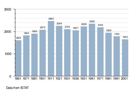
Longi (Sicilian: Lonci) is a comune (municipality) in the Province of Messina in the Italian region Sicily, located about 120 kilometres (75 mi) east of Palermo and about 70 kilometres (43 mi) west of Messina. As of 31 December 2004, it had a population of 1,610 and an area of 42.2 square kilometres (16.3 sq mi).[1]
The municipality of Longi contains the frazioni (subdivisions, mainly villages and hamlets) Stazzone, Crocetta, Pado, and Filipelli.
Longi borders the following municipalities: Alcara li Fusi, Bronte, Cesarò, Frazzanò, Galati Mamertino, Maniace, San Marco d'Alunzio, Tortorici.
Demographic evolution
References
This article is issued from Wikipedia - version of the 6/21/2015. The text is available under the Creative Commons Attribution/Share Alike but additional terms may apply for the media files.