Longford River
| Longford River | |
|---|---|
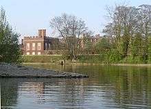
 The Longford River as it enters Bushy Park, viewed from Hampton Hill High Street. The artificial bank of this otherwise natural looking waterway can be seen in the opposite direction. | |
| Country | England |
| Basin | |
| Main source | River Colne, Longford |
| River mouth | River Thames, Hampton Court |
| Physical characteristics | |
| Length | 12 mi (19 km) |
| Longford River | |||||||||||||||||||||||||||||||||||||||||||||||||||||||||||||||||||||||||||||||||||||||||||||||||||||||||||||||||||||||||||||||||||||||||||||||||||||||||||||||||||||||||||||||||||||||||||||||||||||||||||||||||||||||||||||||||||||||||||||||||||||||
|---|---|---|---|---|---|---|---|---|---|---|---|---|---|---|---|---|---|---|---|---|---|---|---|---|---|---|---|---|---|---|---|---|---|---|---|---|---|---|---|---|---|---|---|---|---|---|---|---|---|---|---|---|---|---|---|---|---|---|---|---|---|---|---|---|---|---|---|---|---|---|---|---|---|---|---|---|---|---|---|---|---|---|---|---|---|---|---|---|---|---|---|---|---|---|---|---|---|---|---|---|---|---|---|---|---|---|---|---|---|---|---|---|---|---|---|---|---|---|---|---|---|---|---|---|---|---|---|---|---|---|---|---|---|---|---|---|---|---|---|---|---|---|---|---|---|---|---|---|---|---|---|---|---|---|---|---|---|---|---|---|---|---|---|---|---|---|---|---|---|---|---|---|---|---|---|---|---|---|---|---|---|---|---|---|---|---|---|---|---|---|---|---|---|---|---|---|---|---|---|---|---|---|---|---|---|---|---|---|---|---|---|---|---|---|---|---|---|---|---|---|---|---|---|---|---|---|---|---|---|---|---|---|---|---|---|---|---|---|---|---|---|---|---|---|---|---|---|
Legend | |||||||||||||||||||||||||||||||||||||||||||||||||||||||||||||||||||||||||||||||||||||||||||||||||||||||||||||||||||||||||||||||||||||||||||||||||||||||||||||||||||||||||||||||||||||||||||||||||||||||||||||||||||||||||||||||||||||||||||||||||||||||
| |||||||||||||||||||||||||||||||||||||||||||||||||||||||||||||||||||||||||||||||||||||||||||||||||||||||||||||||||||||||||||||||||||||||||||||||||||||||||||||||||||||||||||||||||||||||||||||||||||||||||||||||||||||||||||||||||||||||||||||||||||||||
The Longford River is an English artificial waterway, a distributary designed to embellish a park, that diverts water 12 miles (19 km) from the River Colne at Longford near Colnbrook to Bushy Park and Hampton Court Palace where, at both, it has outlets to the Thames, on the reaches above Teddington Lock and Molesey Lock respectively. It was built for King Charles I in 1638/39 as a water supply for Hampton Court, and water features in Bushy Park were added in 1710. Its course has been diverted (north of the A30) more than once as London Heathrow Airport has grown. Its cascades, grassed banks and fountains in Bushy Park were restored and reopened to the public in 2009 to close to their original state.
Route
In its northern course, it runs side by side with its older "twin", the Duke of Northumberland's River, both of which have historically been re-dug nearby to accommodate the development of Heathrow Airport. Most recently they were diverted as part of the Twin Rivers Diversion Scheme to allow the construction of Terminal 5. The two rivers emerge to flow along the Airport's southern perimeter, separating at 'Two Bridges' just east of Terminal 4.
The Longford River then flows south east, through Bedfont, Feltham and Hanworth, where it flows through two culverts, one under a school to the west of Hanworth Park, and another from the centre of the park to its eastern boundary. The river then forms the boundary between Hampton and Hampton Hill before crossing over the Shepperton Branch Line on an aqueduct and running through Bushy Park to Hampton Court.[1] Three main outlets exist into the Thames, near to Hampton Gate of Bushy Park, under the Water Gallery at Hampton Court Palace Gardens opposite the confluence of the River Mole, and one in the east of that land, which is a mixture of golf course and farm, opposite Raven's Ait.
Ownership, which comes with an upkeep cost is with the Royal Parks Agency. Relatively small, laws have rarely been needed to be used against others related to pollution or various offences of dumping.
History
Constructed in 1638/39 at the instigation of Charles I, the purpose of the Longford River was to bring water from the River Colne to augment the water supply to the Royal Parks at Bushy Park and Hampton Court. It was designed by Nicholas Lane, and took around nine months to build, at a cost of £4,000.[2] It was not universally popular, as it was illegally stopped up in 1648 or 1649, and petitions were presented to the authorities in 1653, arguing that it should not be reopened, as it caused flooding which damaged crops and livestock.[3]
At Longford, Bath Road crosses the Duke of Northumberland's River, the Longford River and the River Colne. It was once the main route to the southwest, but has since been bypassed to the north by the A4 road, which crosses the Colne above its junction with the Longford River. Longford Bridge carries Bath Road over the Duke's River, while Moor Bridge carries it over the Colne. A bridge was built over the Longford River when it was constructed, but it was demolished in 1648, and is known to have been reinstated by 1675. It was known as Stone Bridge in the nineteenth century, and the responsibility for keeping it in good order belonged to the Crown. Another name change had taken place by 1960, when it was known as King's Bridge.[3]
Before the 20th century, the river was known variously as the New River, the King's River, the Queen's River, the Cardinal's River, the Hampton Court Cut, and the Hampton Court Canal. At its western end it flowed across land which was wanted for the extension of Heathrow Airport in the 1940s, and so it and the adjacent Duke of Northumberland's River were diverted into a single channel around the south boundary of the extended airport.[3]
Before Heathrow Airport Terminal 5 was built, the Longford River and the Duke of Northumberland's River passed under the runways in culverts. As part of that project they were re-routed in open channels around the west edge of the airport. A new 3.7-mile (6.0 km) channel was constructed for each river, over 75 per cent of which were made from pre-cast panels manufactured off-site. Despite this construction method, biodiversity was encouraged by the use of hazel hurdles and coir rolls, pre-planted with native species, to provide habitat for small mammals. Habitat for fish was provided by creating meandering flow patterns using gravel and recycled trees, and the channels were populated with some 84,000 river plants. Water voles, plants, fish, freshwater mussels and silts from the original river bed were moved to the new channel to assist its regeneration, and landscaping involved planting 450 semi-mature trees, 2,000 shrubs and 100,000 groundcover shrubs. The scheme took 18 months to complete, and is now managed by the Twin Rivers Management Committee, with representatives from Heathrow Airport, the Environment Agency and the Royal Parks Agency. It was awarded a Civil Engineering Environmental Quality (CEEQUAL) Award, in recognition of the fact that it was completed on time, to budget, and maintained very high environmental standards throughout its construction.[4]
Water features


At its eastern end, the river fed water features in Bushy Park and Hampton Court. To celebrate his queen, Henrietta Maria, Charles I had a statue and fountain made, which although called the Diana fountain depicts Arethusa, a water nymph, rather than the Roman goddess of hunting. This was moved to Hampton Court from Somerset House by Oliver Cromwell, and repositioned in the centre of a circular pond in Bushy Park by Sir Christopher Wren when he redesigned the gardens in 1713.[5] The water gardens in Bushy Park were developed by the 1st Earl of Halifax in 1710.[6]
During the First World War, Bushy Park was used to station Canadian troops, and during the Second World War was used by the USA Air Force. General Eisenhower was based there when the Allied invasion of north-west Europe was planned, which began with the D-Day landings. Most of the huts erected to accommodate them had been removed by 1963,[5] but the park remained in military occupation, as the Admiralty used it as a research establishment during the Cold War. By the time military use had ceased in the early 1990s, much of the site was overgrown and damaged, but a group called the Friends of Bushy and Home Parks was formed, and began to research what was there. Aided by the discovery of an eighteenth-century painting of the park and archaeological investigation, a restoration programme for the whole park was developed, for which funding of £7.2 million was provided by the Heritage Lottery Fund, the Royal Parks and others. Preliminary investigation work began in 2006, with the main part of the project starting in January 2008, which involved dredging large volumes of silt from the ponds, restoring them to their original shape, and overhauling the water engineering system, to reconnect them to the Longford River. The cascades and flank walls were restored using original stonework and bricks where they could be found.[6] The Longford River had been diverted by the Admiralty in 1953 while they were using the park, which had resulted in 5 feet (1.5 m) of silt building up in the ponds. Its removal revealed two extra steps of the cascades. The river was returned to its earlier course, and water flowed down the cascades for the first time on 15 September 2008. A new bridge was constructed over the river to link the Brew House to the water gardens, and the Baroque water gardens were reopened to the public in 2009. The cost of restoring them was £780,000.[7][8]
At Hampton Court, the dominating feature of the grounds is the landscaping scheme constructed for the new palace by Sir Christopher Wren. There is a water-bounded semicircular parterre, the length of the east front. Three avenues radiate in crow's foot pattern into Hampton Court Park. The central avenue contains the great canal, known as the Long Water, excavated during the reign of Charles II, in 1662. The design, radical at the time, is influenced by Versailles, and was laid out by pupils of André Le Nôtre, Louis XIV's landscape gardener.[9] At the eastern end of the Long Water is the Golden Jubilee Fountain. This was opened in November 2002 by Queen Elizabeth II, and features five jets, the largest of which rises to a height of 98 feet (30 m).[10]
Points of interest
| Point | Coordinates (Links to map resources) |
OS Grid Ref | Notes |
|---|---|---|---|
| Junction with River Colne | 51°28′51″N 0°29′32″W / 51.4809°N 0.4923°W | TQ047768 | Start of channel |
| Bridge for Terminal 5 access road | 51°27′46″N 0°29′20″W / 51.4629°N 0.4890°W | TQ050748 | Channel follows Heathrow Airport boundary |
| Duke of Northumberland's River diverges | 51°27′12″N 0°25′45″W / 51.4532°N 0.4291°W | TQ092738 | |
| Feltham Station bridge | 51°27′12″N 0°25′45″W / 51.4532°N 0.4291°W | TQ092738 | |
| Culvert under school | 51°26′33″N 0°24′08″W / 51.4424°N 0.4021°W | TQ111727 | |
| Culvert under Hanworth Park | 51°26′25″N 0°23′38″W / 51.4404°N 0.3938°W | TQ117724 | |
| Aqueduct over Shepperton Branch Line | 51°25′24″N 0°21′40″W / 51.4232°N 0.3612°W | TQ140706 | |
| Weir at entrance to Bushy Park | 51°25′17″N 0°21′15″W / 51.4214°N 0.3543°W | TQ145704 | |
| Western junction with River Thames | 51°24′36″N 0°21′09″W / 51.4101°N 0.3526°W | TQ146691 | Opposite River Mole |
| Diana Fountain in Bushy Park | 51°24′36″N 0°20′11″W / 51.4100°N 0.3364°W | TQ158691 | |
| Eastern junction with River Thames | 51°23′59″N 0°18′39″W / 51.3996°N 0.3109°W | TQ175680 | By Ravens Ait |
See also
Bibliography
- Baker, T F T; Cockburn, J S; Pugh, R B (1971). A History of the County of Middlesex: Volume 4. Victoria County History. British History Online. ISBN 978-0-19-722727-5.
- Dynes, Wayne (1968). Palaces of Europe. London: Hamlyn. ISBN 978-1-299-84804-7. OCLC 37658.
References
- ↑ Longford River – OpenStreetMap (Map). Cartography by OpenStreetMap contributors. OpenStreetMap. Retrieved 21 June 2012.
- ↑ "History and Architecture". The Royal Parks. Retrieved 2012-02-01.
- 1 2 3 Baker, Cockburn & Pugh 1971, pp. 1–7
- ↑ "Sustainable Construction at Terminal 5" (PDF). IEMA. Retrieved 2012-02-01.
- 1 2 "Bushy Park - A patchwork of history". The Royal Parks. Retrieved 2012-02-01.
- 1 2 "The Upper Lodge Water Garden". The Royal Parks. Retrieved 2012-02-01.
- ↑ "Bushy Telegraph No. 8" (PDF). The Royal Parks. Retrieved 2012-02-01.
- ↑ "The Story of Water in Bushy Park". London Parks and Gardens Trust. Retrieved 2012-02-01.
- ↑ Dynes 1968.
- ↑ "Hampton Court Palace" (PDF). Historic Royal Palaces. pp. 7–8. Retrieved 14 March 2015.
| Next confluence upstream | River Thames | Next confluence downstream |
| River Ash (north) | Longford River, Water Gallery, Bushy Park (north) | River Mole & River Ember (south) |
| The Rythe (south) | Longford River, Raven's Ait, Hampton Court Park (north) | Hogsmill River (south) |
Coordinates: 51°25′10″N 0°21′09″W / 51.41944°N 0.35250°W