Longford, London
| Longford | |
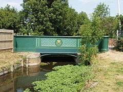 Bridge over the 17th century-built Longford River[1] |
|
 King Henry's 'Public House' and The Stables brick infilled timber-frame older homes |
|
 Longford |
|
| OS grid reference | TQ045765 |
|---|---|
| – Charing Cross | 15.8 mi (25.4 km) E |
| London borough | Hillingdon |
| Ceremonial county | Greater London |
| Region | London |
| Country | England |
| Sovereign state | United Kingdom |
| Post town | WEST DRAYTON |
| Postcode district | UB7 |
| Dialling code | 01753 |
| Police | Metropolitan |
| Fire | London |
| Ambulance | London |
| EU Parliament | London |
| UK Parliament | Hayes and Harlington |
| London Assembly | Ealing and Hillingdon |
Coordinates: 51°28′40″N 0°29′39″W / 51.4777°N 0.4943°W
Longford is a village that has never had a church so can also be considered a hamlet, immediately north-west of London Heathrow Airport in the London Borough of Hillingdon, formerly part of Harmondsworth by tithes, land tax, vestry and still by Church of England parish. Its historic county is Middlesex. Longford is 15.8 miles (25.4 km) west of Charing Cross and within the M25 motorway which marks its western boundary with Colnbrook, Berkshire.
Etymology
The name Longford derives from the two words "long" and "ford", after the wide ford across the Colne which is where the old Bath Road crosses it, a middle ditch, and the Wraysbury River, carrying on west from the village street. Its old country residents pronounced its name as "Long Ford" with both syllables stressed.
History
The settlement developed by this multi-channel ford of the River Colne and its distributaries, which presented numerous obstacles for travellers to and from the west of the edge of London's county of Middlesex, on the old Bath Road. Longford may be founded on a small Saxon settlement dating from the 5th to 7th century AD. Historic buildings survive from the medieval and immediate post-medieval periods. Limited evidence survives of Roman occupation, though archaeological excavations have revealed two brooches of Roman date.[2]
Longford, the only medieval settlement to grow up along the Bath Road in Middlesex, had 30 inhabited buildings in 1337. An important part of the parish economy, aside from its four manor houses, 48 houses were on Moor and Sheep Lanes in Harmondsworth.[2]
In 1586 land on either side of the river was charged with the upkeep of Mad Bridge, which carried the Bath Road across the river. During the 18th and early 19th centuries this bridge was maintained by the Colnbrook turnpike trustees, who presumably erected in 1834 the bridge with cast-iron parapets which now stands.[2]
Rocque's map of 1754, shows clearly the settlement pattern: at Longford, Harmondsworth, Sipson there were small compact groups of houses, and a straggling group at Heathrow. At Longford they lined both sides of the Bath Road from the east bank of the Longford River up to and across the Duke of Northumberland's River.[2]
The uncultivated area west of the rivers was to the north known as Harmondsworth moors, south of the Bath Road the area between the Colne and the Longford rivers was meadowland and, between the Longford and the Duke's rivers, arable.
Parliament's Act of common land inclosure (privatisation) came to Harmondsworth parish in 1819; in it Harmondsworth's three open fields and Harmondsworth Moor and a big tract to and around Heathrow (part of Hounslow Heath) were divided among the local residents. During this Enclosure two bad bends of the Bath Road in Longford were straightened.[3]
By 1839 Longford and Harmondsworth and Sipson had a shop.[2]
In 1929 the Longford and Colnbrook by-pass was built.
In 1930 the Road Research Laboratory on the Colnbrook by-pass opened. In the same year the Fairey Aviation Company opened an airfield, the Great West Aerodrome, southeast of Heathrow village.
About 1930 a brickworks was set up east of the junction of Cain's Lane and Heathrow Road in Heathrow. Later the quarry's main purpose changed to excavating sand and gravel. The quarry company went bankrupt in 1943, and in 1944 and after the airport obliterated it and everything of Heathrow village.
Middlesex County Council opened a large sewage sludge settlement works west of Perry Oaks farm; in the 1990s it was removed and Heathrow Airport's Terminal 5 is there now.
- Bridge and river pictured
In 1648 the first bridge across the then new Longford River was demolished. This had been replaced by 1675. In the 19th century, when it was called Stone Bridge, the Crown, not a local authority, was responsible for its upkeep and by 1960 it had been renamed King's Bridge.[2]
Geography
Longford village is a linear development astride the Bath Road immediately north of Heathrow Airport and as such to the south of the M4, It is also immediately north of Heathrow's Western Perimeter Road. The area is characterized by an historic village core and similar-sized green buffer zones.
The last bridge or ford in the west over the Wraysbury River marked the boundary of Colnbrook which has been superseded by the M25 motorway which the road then crosses over.
The Duke of Northumberland's River that runs from here to Isleworth since its construction in or about 1543.[2]
Soil and elevation
Elevation is an almost uniform 22 metres (72 ft).
Longford's soil is the rich western soil of the historic parish of Harmondsworth, being alluvial. Shortly south of the main street gravel is instead close to the surface except near rivers and northeastward of the village, and less fertile clay soil dominates for many miles.[2]
Transport
Immediately to the north is a purpose-built bypass with a western junction connected A4, to the M4 that is, which is parallel and has two junction with this road also directly north of Heathrow airport, with the newer Junction 14 for Terminal 5 a very limited access junction, for the airport roads only.
Access to the M25 motorway is considerably shortest to the south, at Junction 14 (Stanwell Moor).
The Bath Road (A4) is an arterial road and traffic along it became so dense so early that in 1928 a bypass to Longford and Colnbrook was opened.
Landmarks
Longford retains an old-fashioned community centre character, in particular a former and an existing public house which are listed buildings only at Grade II mostly on age rather than simply architecture.[4] An old building, Yeomans, which has been subdivided into three flats is listed.[5] Other listed buildings include Longford Cottage, Queen River Cottage and adjoining Willow Tree Cottage,[6] and King's Bridge which is the name of the 1834-built main bridge by the very last building at the west end of the (old) Bath Road street, which crosses the nearby siphoned off Longford River, which Charles I had constructed — this feeds Bushy Park and Hampton Court Gardens.[7]
One of the listed cottages is thatched.[8]
Longford Village Conservation Area
Much of the land surrounding the village of Longford is within the Metropolitan Green Belt.[9] Many of its buildings are included in the Longford Village Conservation Area, which was designated in 1988 with a minor boundary change in 1999. It includes seven listed buildings, one listed wall and a number of unlisted properties which are considered to make an important contribution to the character and appearance of the Conservation Area.[10]
Effect of Proposed Heathrow Runway 3
On 1 July 2015, the Airports Commission recommended that the Government approve Heathrow Airport having a third runway in the form of the Northwest Runway scheme put forward by Heathrow Airport Ltd. The plan on page 99 of the Airports Commission report confirms that the proposal requires the demolition of every building at Longford.[11]
Religion
Of residents of the output area Hillingdon 31A (Cranford, Longford and West Harmondsworth) 938 people (or 51.2%) declared themselves to be Christian in 2011. Also in this area 11.9% of people were Muslim, 11% Sikh, 1.9% Buddhist, 13.3% of no recognised religion, 5.9% gave no religious status and 1% were of other religions.
The ecclesiastical parish of the Church of England remains in Harmondsworth at St Mary's.
The Catholic Church have a church in central West Drayton to the north, as well as three chaplains who serve St George's Chapel in Heathrow's inner ring west or the Sunday Mass at Terminals 4 and 5.[12]
Gurdwaras exist on Martindale and Hanworth Road, Hounslow, the latter being Sri Guru Singh Sabha. The nearest Islamic centre is the Al-Falah Muslim Centre, Tavistock Road, Yiewsley to the north.
References
Philip Sherwood, History and Guide to Harlington and Harmondsworth (Harlington: PT Sherwood, 2002)
- ↑ Local history page at This is Longford
- 1 2 3 4 5 6 7 8 T F T Baker, J S Cockburn, R B Pugh (Editors), Diane K Bolton, H P F King, Gillian Wyld, D C Yaxley (1971). "Harmondsworth: Introduction". A History of the County of Middlesex: Volume 4: Harmondsworth, Hayes, Norwood with Southall, Hillingdon with Uxbridge, Ickenham, Northolt, Perivale, Ruislip, Edgware, Harrow with Pinner. Institute of Historical Research. Retrieved 19 August 2013.
- ↑ The Villages of Harmondsworth, edited by Philip Sherwood, publ. West Middlesex Family History Society, 1993
- ↑ King Henry and Stables (opened before 1775, closed 20th century) Historic England. "Details from listed building database (1080296)". National Heritage List for England.
White Horse — 17th century, restored Historic England. "Details from listed building database (1192507)". National Heritage List for England. - ↑ Yeomans Historic England. "Details from listed building database (1080298)". National Heritage List for England.
- ↑ Queen River Cottage and Willow Tree CottageHistoric England. "Details from listed building database (1358336)". National Heritage List for England.
- ↑ King's BridgeHistoric England. "Details from listed building database (1080299)". National Heritage List for England.
- ↑ Image of the Thatched Cottage with modern houses behind at geograph.org.uk
- ↑ "Unitary Development Plan – Proposals Map (Heathrow West)". Retrieved 2015-09-15.
- ↑ "Longford Village Conservation Area Appraisal – March 2007". London Borough of Hillingdon. Retrieved 2015-09-15.
- ↑ "Airport Commission: final report". Retrieved 2015-09-15.
- ↑ The Roman Catholic Diocese of Westminster
External links
| Wikimedia Commons has media related to Longford, London. |
| Districts | 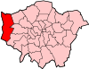 | |
|---|---|---|
| Attractions |
| |
| Parks and open spaces |
| |
| Constituencies | ||
| Local government | ||
| Tube and rail stations | ||
| Places of worship | ||
| Other topics | ||
| ||