Long Ashton railway station
| Long Ashton | |
|---|---|
|
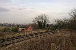
The site of Long Ashton railway station. | |
| Location | |
| Place | Long Ashton |
| Area | North Somerset |
| Operations | |
| Original company | Bristol and Exeter Railway |
| Pre-grouping | Great Western Railway |
| Platforms | 2 |
| History | |
| 14 June 1841 or June 1852 | Opened as Ashton |
| January 1856 | Closed |
| 12 July 1926 | Reopened as Long Ashton Platform |
| 6 October 1941 | Closed |
| Disused railway stations in the United Kingdom | |
|
Closed railway stations in Britain A B C D–F G H–J K–L M–O P–R S T–V W–Z | |
|
| |
Long Ashton railway station was a railway station on the Bristol to Exeter Line, 3.5 miles (5.6 km) southwest of Bristol Temple Meads, serving the village of Long Ashton in North Somerset, England. There were two stations on the site, the first, called "Ashton", opened in either 1841 or 1852 and closed in 1856. The second station, originally known as "Long Ashton Platform" before being renamed as "Long Ashton" in 1929, was operational from 1926 to 1941. The site is now partly under the A370 Long Ashton Bypass, and there are no visible remains of the station. There is local support for the station to be reopened, possibly sited further to the west, and possibly as part of the University of Bristol's proposed Fenswood Farm development.
First station
The Bristol and Exeter Railway was opened between Bristol Temple Meads and Bridgwater on 14 June 1841, engineered by Isambard Kingdom Brunel and build originally as 7 ft (2,134 mm) broad-gauge. A station named "Ashton", serving the nearby village of Long Ashton, was located on an embankment 3 miles 52 chains (5.87 km) from Bristol Temple Meads and 122 miles 3 chains (196.40 km) from the Great Western Railway terminus at London Paddington.[1][2][note 1] Quite when the station opened is uncertain – Butt's Directory of Railway Stations states that the station opened with the line in June 1841,[3] but Quick's Railway Passenger Stations states it only opened in June 1852.[4] Both sources agree that the station closed in January 1856,[3][4] however other sources such as Oakley's Somerset Railway Stations contain no reference to Ashton at all.[5] If the earlier date is correct, services would have originally been provided by the Great Western Railway on behalf of the Bristol & Exeter. The Bristol & Exeter took over passenger operations on 1 May 1849.[6]
The line through Ashton remained open after the station closed. In 1871, the Bristol & Exeter opened another station called Ashton, closer to Bristol, this station was later renamed Bedminster.[3] The line had been reconstructed as mixed-gauge by 1 June 1875 to accommodate local traffic. A year later in 1876, the Bristol & Exeter was amalgamated into the Great Western Railway, which took over services. Broad-gauge trains ceased operation on 20 May 1892.[6]
| Preceding station | Historical railways | Following station | ||
|---|---|---|---|---|
| Bristol Temple Meads | Bristol and Exeter Railway (1841 or 1852 – 1856) |
Nailsea and Backwell | ||
Second station
The station was reopened by the Great Western Railway in 1926, now called Long Ashton Platform; Ashton by then was the name of a station on the Teign Valley Line in Devon. Again, the exact date of opening is disputed: most sources state 12 July 1926,[5][7][8] but some say 20 September the same year.[9] It was located on the same site as the first station.[2]
The station was a basic halt, and had two 400 × 10 feet (121.9 × 3.0 m) platforms. A corrugated iron shelter and lamp hut were provided on the westbound platform, and a small booking office was present on the road to the platform. The estimated cost of construction was £1,930.[5]
The station was renamed Long Ashton on 23 September 1929, and closed on 6 October 1941.[5][7] There is now no trace of it left,[5] and the site is now partly under the A370 Long Ashton Bypass causeway.[10]
| Preceding station | Historical railways | Following station | ||
|---|---|---|---|---|
| Bedminster | Great Western Railway Bristol to Exeter Line (1926-27) |
Flax Bourton Line open, station closed. | ||
| Parson Street | Great Western Railway Bristol to Exeter Line (1927-41) |
|||
Future
Plans were submitted in 2010 to reopen the station as part of the University of Bristol's Fenswood Farm development, which, if granted planning permission, will comprise some 1,200 houses, businesses and a school spread over 35 hectares (86 acres).[11] The new station would be up to 1 mile (1.6 km) west of the original location. The University notes that there is positive support for the station, but that it alone cannot guarantee its construction.[12] Long Ashton parish councillor Anthony Butcher opposes the development, but supports the reopening of the station.[13] The station could be reopened as part of the Greater Bristol Metro scheme,[14] a rail transport plan approved in July 2012 which aims to enhance transport capacity in the Bristol area.[15]
The Bristol to Exeter Line through Long Ashton is not currently electrified. The 21st-century modernisation of the Great Western Main Line will see the line from London to Bristol electrified, but electrification will not extend beyond Bristol to Weston-super-Mare.[16][17] The group Friends of Suburban Bristol Railways supports the electrification continuing to Weston,[18][19] as does Member of Parliament for Weston-super-Mare John Penrose.[17][20]
Notes
- ↑ Railways in the United Kingdom are, for historical reasons, measured in miles and chains. There are 80 chains to the mile.
References
- ↑ Deaves, Phil. "Engineers' Line References: MLN1 Paddington to North Road Junction". Retrieved 11 April 2012.
- 1 2 Cobb, M.H. Railways of Great Britain: A Historical Atlas. Ian Allen. ISBN 9780711032361.
- 1 2 3 Butt, R. V. J. (1995). The Directory of Railway Stations: details every public and private passenger station, halt, platform and stopping place, past and present (1st ed.). Sparkford: Patrick Stephens Ltd. p. 20. ISBN 1-8526-0508-1. OCLC 60251199.
- 1 2 Quick, Michael (2009) [2001]. Railway passenger stations in Great Britain: a chronology (4th ed.). Oxford: Railway and Canal Historical Society. p. 64. ISBN 978-0-901461-57-5. OCLC 612226077.
- 1 2 3 4 5 Oakley, Mike (2002). Somerset Railway Stations. Bristol: Redcliffe. ISBN 1-90453-754-5.
- 1 2 MacDermot, E.T. (1931). History of the Great Western Railway, vol. II: 1863–1921. Paddington: Great Western Railway. pp. 133–4, 617. OCLC 55853736.
- 1 2 Butt, R. V. J. (1995). The Directory of Railway Stations: details every public and private passenger station, halt, platform and stopping place, past and present (1st ed.). Sparkford: Patrick Stephens Ltd. p. 148. ISBN 1-8526-0508-1. OCLC 60251199.
- ↑ Clinker, C.R. (1978). Clinker's Register of Closed Passenger Stations and Goods Depots in England, Scotland and Wales, 1830-1977. Avon-Anglia Publications and Services. ISBN 0905466195.
- ↑ Nock, O.S. (1967). History of the Great Western Railway, vol. 3: 1923-1947. Shepperton: Ian Allan. p. 248. ISBN 0 7110 0304 1.
- ↑ OS Landranger Map 172 – Bristol & Bath. Southampton: Ordnance Survey. 2008. ISBN 978-0-319-22914-9.
- ↑ Butcher, Anthony (7 January 2011). "Fenswood Farm". Retrieved 10 April 2012.
- ↑ "The future of University-owned land at Long Ashton - questions and answers". University of Bristol. Retrieved 10 April 2012.
- ↑ Butcher, Anthony (7 January 2011). "Train station for Long Ashton". Retrieved 10 April 2012.
- ↑ "Bristol's metro is not as far off track as you might think". Bristol Evening Post. 30 June 2011. Retrieved 10 April 2012.
- ↑ Ribbeck, Michael (6 July 2012). "£100 million Bristol Metro train network by 2016". The Post, Bristol. Northcliffe Media. Retrieved 6 July 2012.
- ↑ "Bristol to London line to be electrified". This is Bristol. Northcliffe Media. 23 July 2009. Retrieved 5 April 2012.
- 1 2 "Weston's rail commuter services could be cut, warns town's MP" (Press release). John Penrose MP. 17 July 2009. Retrieved 5 April 2012.
- ↑ "Benefits of Bristol to London high-speed rail link 'must go beyond just mainline'". This is Bristol. Northcliffe Media. 3 March 2011. Retrieved 5 April 2012.
- ↑ "FoSBR Newsletter" (PDF). Friends of Suburban Bristol Railways. Autumn 2011. Retrieved 9 April 2012.
- ↑ "MP takes drive for better rail services to top". This is Bristol. 29 October 2011. Retrieved 5 April 2012.
Coordinates: 51°25′38″N 2°38′59″W / 51.42716°N 2.64961°W