Longs Peak
| Longs Peak | |
|---|---|
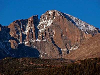 Longs Peak seen from the east at sunrise. | |
| Highest point | |
| Elevation | 14,259 ft (4346 m) [1] NAVD88 |
| Prominence | 2940 ft (896 m) [2] |
| Isolation | 43.6 mi (70.2 km) [2] |
| Listing | |
| Coordinates | 40°15′18″N 105°36′54″W / 40.2550135°N 105.6151153°WCoordinates: 40°15′18″N 105°36′54″W / 40.2550135°N 105.6151153°W [1] |
| Geography | |
 Longs Peak | |
| Location |
High point of Rocky Mountain National Park and Boulder County, Colorado, U.S.[2] |
| Parent range |
Front Range, Highest summit of the Twin Peaks Massif[2] |
| Topo map |
USGS 7.5' topographic map Longs Peak, Colorado[3] |
| Climbing | |
| First ascent | 1868 by John Wesley Powell and party |
| Easiest route | Keyhole (scramble) Class 3+ |
Longs Peak is a high and prominent mountain summit in the northern Front Range of the Rocky Mountains of North America. The 14,259-foot (4346 m) fourteener is located in the Rocky Mountain National Park Wilderness, 9.6 miles (15.5 km) southwest by south (bearing 209°) of the Town of Estes Park, Colorado, United States. Longs Peak is the northernmost fourteener in the Rocky Mountains and the highest point in Boulder County and Rocky Mountain National Park. The mountain was named in honor of explorer Stephen Harriman Long and is featured on the Colorado state quarter.[1][2][3][4][5]
Mountain
Longs Peak can be prominently seen from Longmont, Colorado, as well as from most of the northern Front Range Urban Corridor. Longs Peak is one of the most prominent mountains in Colorado, rising 9,000 feet (2,700 m) above the western edge of the Great Plains.
The peak is named for Major Stephen Long,[6][7] who is said to be the first to spot the great mountains on behalf of the U.S. Government on June 30, 1820.
Together with the nearby Mount Meeker, the two are sometimes referred to as the Twin Peaks (not to be confused with a nearby lower mountain called Twin Sisters).
History of ascents
As the only fourteener in Rocky Mountain National Park, the peak has long been of interest to climbers. The easiest route is not "technical" during the summer season. It was probably first used by pre-Columbian indigenous people collecting eagle feathers.
The first recorded ascent was in August 23, 1868 by the surveying party of John Wesley Powell via the south side.[7] The East Face of the mountain is 1,675 feet steep and is surmounted by a 1,000 feet steep sheer cliff known as "The Diamond"[7] (so-named because of its shape, approximately that of a cut diamond seen from the side and inverted - see image at right). Another famous profile belongs to Longs Peak: to the southeast of the summit is a series of rises which, when viewed from the northeast, resembles a beaver. The photo shows the beaver climbing the south (left side) of the mountain.
In 1954 the first proposal made to the National Park Service to climb The Diamond was met with an official closure, a stance not changed until 1960. The Diamond was first ascended by Dave Rearick and Bob Kamps that year, by a route that would come to be known simply as D1. This route would later be listed in Allen Steck and Steve Roper's influential book Fifty Classic Climbs of North America.[8][9] The easiest route on the face is the Casual Route (5.10a),[10] first climbed in 1977. It has since become the most popular route up the wall.
The oldest person to summit Longs Peak was Rev. William "Col. Billy" Butler, who climbed it on September 2, 1926, his 85th birthday. In 1932, Clerin “Zumie” Zumwalt summited Longs Peak 53 times.[11]
On June 6, 2016, a group of US Special Forces were rescued after members of the team suffered from altitude sickness. [12]
Mills Glacier
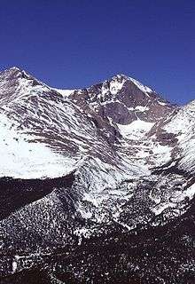
Longs Peak has one remaining glacier named Mills Glacier. The glacier is located around 12,800 feet (3,900 m)[13] at the base of the Eastern Face, just above Chasm Lake. A permanent snowfield, called The Dove, is located north of Longs Peak. Longs Peak is one of fewer than 50 mountains in Colorado that have a glacier.[14]
Hiking Longs Peak
Trails that ascend Longs Peak include the East Longs Peak Trail, the Longs Peak Trail, the Keyhole Route, Clark's Arrow and the Shelf Trail. Only some technical climbing is required to reach the summit of Longs Peak during the summer season, which typically runs from mid July through early September. Outside of this window the popular "Keyhole" route is still open; however, its rating is upgraded to all "technical" as treacherous ice formation and snow fall necessitates the use of specialized climbing equipment including, at a minimum, crampons and an ice axe. It is one of the most difficult Class 3 fourteener scrambles in Colorado.[15] The hike from the trailhead to the summit is 8.4 miles (13.5 km) each way, with a total elevation gain of 4875 feet. Most hikers begin before dawn in order to reach the summit and return below the tree line before frequent afternoon thunderstorms bring a risk of lightning strikes. The most difficult portion of the hike begins at the Boulder Field, 6.4 miles (10 km) into the hike. After scrambling over the boulders, hikers reach the Keyhole at 6.7 miles (10.5 km).
The following quarter of a mile involves a scramble along narrow ledges, many of which may have nearly sheer cliffs of 1,000 feet (305 m) or more just off the edge. The next portion of the hike includes climbing over 600 vertical feet (183 m) up the Trough before reaching the most exposed section of the hike, the Narrows. Just beyond the Narrows, the Notch signifies the beginning of the Homestretch, a steep climb to the football field-sized, flat summit. It is possible to camp out overnight in the Boulder Field (permit required) which makes for a less arduous two-day hike, although this is fairly exposed to the elements. Fifty eight people have died climbing or hiking Longs Peak. According to the National Park Service, two people, on average, die every year attempting to climb the mountain. Less experienced mountaineers are encouraged to use a guide for this summit to mitigate risk and increase the probability of a summit.
For hikers who do not wish to climb to the summit, there are less-involved hikes on the peak as well. Peacock Pool and Chasm Lake are popular hiking destinations and follow well-maintained trails. It is also rewarding to hike just to the Boulder Field, the Keyhole, or the seldom-visited Chasm View—the ridge between Mount Lady Washington and the east face of Longs Peak. Camping is available at the Boulder Field and also on the lower portions of the mountain, such as Goblin's Forest next to the stream at the bottom. Technical climbers, with the correct permit, are allowed to use sites at the base of the East Face and at Chasm View. It is also possible to camp to the south of the mountain at Sand Beach Lake.
Climbing Longs Peak
In addition to the standard "Keyhole" route, there are more serious and more technical climbs on Longs Peak. Climbers should seek qualified instruction; deaths on Longs Peak are an annual occurrence. Some of the more common routes are, in approximate order of popularity,
- North Face Cables route: This follows the Keyhole route to the Boulder Field, then ascends the North Face of the peak. It requires one or two pitches of low-5th class climbing, and is often downclimbed or rappelled by technical climbers since it is one of the fastest ways to ascend or descend the peak. In the early 20th century, enterprising guides installed a series of large steel eye bolts along this route, connecting them with a steel cable similar to systems in the Alps. The cables were removed in 1973 due to concerns about their appropriateness, but several of the bolts remain and are used as rappel anchors.
- Kieners Route: A traditional mountaineering climb that involves a climb of Lambs Slide (named after Reverend Elkanah Lamb who unintentionally slide down much of the route in 1871[7]), which is icy later in the season, then an exposed traverse of the Broadway ledge, and then low-5th class climbing.
- via the Loft: The Loft is the semi-permanent snowfield between Longs Peak and its south-eastern neighbor Mt. Meeker. The saddle provides access to either peak. One such traverse route is Gorrell's Traverse.[16] It is also possible to ascend to the saddle via Lambs Slide.
- via the East Face: The East Face is the steep, 1,000 + foot (305 + m) wall that includes the Diamond and the Lower East Face. All climbs here are technical, from 5.10 to 5.13. It is also possible to ascend to the (climber's) left of the Diamond face proper. The routes on the right side of the Diamond are often aid climbed, and may require spending the night on the wall; the rock here can be very wet. Routes on the left side of the Diamond are usually free climbed. Only qualified climbers should attempt climbs on this face, and should take into consideration the effects of altitude and alpine conditions in addition to the difficulty rating.
- via the Notch Couloir: This is a technical climb involving rock climbing and, at some times of year, ice climbing. The Notch Couloir is to the (climber's) left of the Diamond face.
Historical names
- "Highest Peak"
- "Les Deux Oreilles" (named by French fur traders), translation: "The Two Ears" (Longs Peak and Mount Meeker were both once named this)[7]
- "Longs Peak" – 1890[3]
- "Long's Peak"
- "Nesotaieux"
In literary fiction
Jules Verne's science fiction novels From the Earth to the Moon (1865) and Around the Moon (1870) mention Longs Peak—called Long's Peak—as the site of a 200-inch reflector telescope built for the purpose of tracking the lunar spacecraft.
Gallery
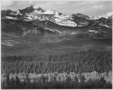 Long's Peak from Road as photographed by Ansel Adams in 1941.
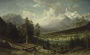 Albert Bierstadt, Estes Park and Longs Peak, 1876, Denver Art Museum was commissioned by the Earl of Dunraven for $15,000 (equivalent to $333,891 in 2015).
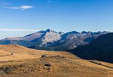
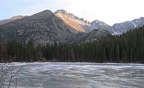 Longs Peak seen from Bear Lake.
 Longs Peak seen from the north.
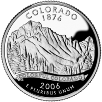 Longs Peak featured on the Colorado state quarter.
See also
References
- 1 2 3 "LONGS PEAK". NGS data sheet. U.S. National Geodetic Survey. Retrieved January 2, 2016.
- 1 2 3 4 5 "Longs Peak, Colorado". Peakbagger.com. Retrieved January 2, 2016.
- 1 2 3 "Longs Peak". Geographic Names Information System. United States Geological Survey. Retrieved November 14, 2014.
- ↑ The elevation of Longs Peak includes an adjustment of +1.652 m (+5.42 ft) from NGVD 29 to NAVD 88.
- ↑ Dziezynski, James (1 August 2012). Best Summit Hikes in Colorado: An Opinionated Guide to 50+ Ascents of Classic and Little-Known Peaks from 8,144 to 14,433 Feet. Wilderness Press. p. 98. ISBN 978-0-89997-713-3.
- ↑ Jessen, Kenneth. "Colorado History: William Byers among first white men to climb Longs Peak". Reporter Herald. Loveland Reporter Herald.
- 1 2 3 4 5 Walter R. Borneman; Lyndon J. Lampert. A Climbing Guide To Colorado's Fourteeners (2 ed.). p. 24. ISBN 0871087510.
- ↑ Roper, Steve; Steck, Allen (1979). Fifty Classic Climbs of North America. San Francisco: Sierra Club Books. ISBN 0-87156-292-8.
- ↑ Jeff Achey; Dudley Chelton; Bob Godfrey (2002). Climb!: The History of Rock Climbing in Colorado. The Mountaineers Books. ISBN 0-89886-876-9.
- ↑ "Casual Route". Mountain Project.
- ↑ "Rocky Mountain National Park - Hiking Essentials".
- ↑ NBC News
- ↑ TopoQuest - Mills Glacier, USGS Longs Peak (CO) Topo Map
- ↑ "Glaciers of Colorado". Glaciers of the American West. Portland State University.
- ↑ "Home of Colorado's Fourteeners and High Peaks". 14ers.com.
- ↑ A Climber's Guide to the Rocky Mountain National Park Area, Walt Fricke, 1971
Further reading
- Stephen Trimble (1984). Longs Peak: A Rocky Mountain Chronicle. ISBN 978-0930487171.
- Paul Nesbit. Longs Peak: Its Story and a Climbing Guide. ISBN 978-0976825913.
- Bernard Gillett (2001). Rocky Mountain National Park: High Peaks: The Climber's Guide. Earthbound Sports. ISBN 0-9643698-5-0.
- Richard Rossiter (1996). Rock and Ice Climbing Rocky Mountain National Park: The High Peaks. Falcon. ISBN 0-934641-66-8.
External links
- "Longs Peak Massif". Peakbagger.com.
- "Longs Peak, Colorado". Peakbagger.com.
- "Longs Peak". SummitPost.org.
- National Park Service guide to climbing Longs Peak
- VIDEO Climbing Longs Peak - DailyCamera.com
