London station group

The London station group is a ring of 18 railway stations served by the National Rail network in central London. Most are terminal stations, although a few are through-stations (that includes those with a combination of terminal and through platforms). Each of these stations is part of a notional "common location" to which tickets from stations outside that group are issued. The station group is rendered on tickets as London Terminals.[1]
All current stations in the group fall within London fare zone 1. The large number of terminal stations is explained by the refusal of Parliament to allow railway lines to enter the centre of London in the 19th century, causing them to form a ring, connected by underground railways.[2] The majority of the larger stations managed by Network Rail are in the group.[3]
Group members
As of 2016, the group comprises:[1][4]
Former members
- Broad Street (closed 1986)
- Holborn Viaduct (closed 1990)
- Kensington (Olympia) (withdrawn 1994)[5]
- Kings Cross Thameslink[6] (closed 2007)
Station statistics
| Station | Image | Location | Coordinates | Managed by |
London services |
National services | Annual entry/exit (millions)[7] | Open date |
Platforms | Category | ||||
|---|---|---|---|---|---|---|---|---|---|---|---|---|---|---|
| 2006/7 | 2007/8 | 2008/9 | 2009/10 | Terminal | Through | |||||||||
| Blackfriars |  |
City of London | 51°30′40″N 0°06′11″W / 51.511°N 0.103°W | Thameslink | NW, N, S, SE | Thameslink, Gatwick Airport, Luton Airport | 11.852 |
12.440 |
12.959 |
12.089 |
1886 | 2 | 2 | A |
| Cannon Street | |
City of London | 51°30′36″N 0°05′24″W / 51.510°N 0.090°W | Network Rail[3] | SE | Kent and East Sussex | 21.106 |
22.045 |
21.646 |
20.229 |
1866 | 7 | 0 | A |
| Charing Cross |  |
Westminster | 51°30′25″N 0°07′23″W / 51.507°N 0.123°W | Network Rail[3] | SE | Kent and East Sussex | 34.779 |
36.294 |
36.660 |
36.460 |
1864 | 6 | 0 | A |
| City Thameslink | 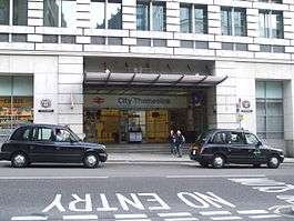 |
City of London | 51°30′58″N 0°06′11″W / 51.516°N 0.103°W | Thameslink | NW, N, S, SE | Thameslink, Gatwick Airport, Luton Airport | 5.479 |
5.370 |
5.294 |
5.163 |
1988 | 0 | 2 | C |
| Euston |  |
Camden | 51°31′41″N 0°07′59″W / 51.528°N 0.133°W | Network Rail[3] | NW | West Coast Main Line | 25.585 |
28.739 |
31.179 |
30.068 |
1837 | 18 | 0 | A |
| Fenchurch Street |  |
City of London | 51°30′40″N 0°04′41″W / 51.511°N 0.078°W | Network Rail[3] | E | Southend-on-Sea | 15.189 |
15.976 |
16.576 |
15.093 |
1841 | 4 | 0 | A |
| Kings Cross |  |
Camden | 51°31′55″N 0°07′23″W / 51.532°N 0.123°W | Network Rail[3] | N | East Coast Main Line | 22.504 |
23.945 |
24.641 |
24.818 |
1852 | 12 | 0 | A |
| Liverpool Street |  |
City of London | 51°31′05″N 0°04′52″W / 51.518°N 0.081°W | Network Rail[3] | E, NE | East of England, Stansted Airport | 55.266 |
57.790 |
56.198 |
51.596 |
1874 | 18 | 0 | A |
| London Bridge |  |
Southwark | 51°30′18″N 0°05′10″W / 51.505°N 0.086°W | Network Rail[3] | S, SE, NW | Kent, East Sussex, Gatwick Airport | 47.577 |
50.602 |
49.901 |
48.723 |
1836 | 9 | 6 | A |
| Marylebone |  |
Westminster | 51°31′19″N 0°09′47″W / 51.522°N 0.163°W | Chiltern Railways | NW | Birmingham | 11.639 |
11.559 |
11.645 |
11.758 |
1899 | 6 | 0 | A |
| Moorgate |  |
City of London | 51°31′05″N 0°05′17″W / 51.518°N 0.088°W | London Underground | N | Hertfordshire | 9.236 |
10.109 |
9.374 |
6.737 |
1865 | 2 | 0 | E |
| Old Street | 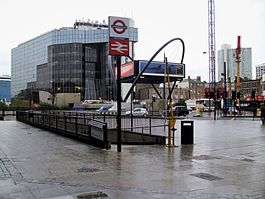 |
Islington | 51°31′30″N 0°05′13″W / 51.525°N 0.087°W | London Underground | N | Hertfordshire | 0.734 | 0.813 |
0.828 |
1.372 |
1901 | 0 | 2 | E |
| Paddington |  |
Westminster | 51°31′01″N 0°10′37″W / 51.517°N 0.177°W | Network Rail[3] | W | Great Western Main Line, Heathrow Airport | 27.259 |
26.521 |
32.697 |
29.104 |
1854 | 14 | 0 | A |
| St Pancras |  |
Camden | 51°31′48″N 0°07′30″W / 51.530°N 0.125°W | Network Rail,[3] HS1 Ltd. and Eurostar International Limited[8] | N, NW, S, SE | Midland Main Line, Gatwick Airport, Luton Airport, High Speed 1 (Kent), Eurostar (Belgium and France) | 5.777 |
6.624 |
19.326 |
18.020 |
1868 | 13 | 2 | A/C |
| Vauxhall | 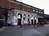 |
Lambeth | 51°29′06″N 0°07′19″W / 51.485°N 0.122°W | South West Trains | SW | South West England | 10.469 |
15.420 |
14.582 |
13.890 |
1848 | 0 | 10 | B |
| Victoria | 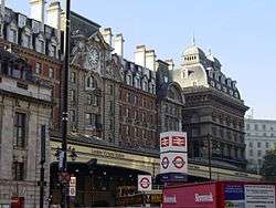 |
Westminster | 51°29′46″N 0°08′38″W / 51.496°N 0.144°W | Network Rail[3] | S, SE, SW | Kent, Sussex, Gatwick Airport | 66.749 |
70.854 |
70.157 |
70.224 |
1862 | 19 | 0 | A |
| Waterloo |  |
Lambeth | 51°30′11″N 0°06′47″W / 51.503°N 0.113°W | Network Rail[3] | SW | South West England | 89.993 |
91.452 |
88.548 |
86.397 |
1848 | 22 | 0 | A |
| Waterloo East |  |
Lambeth | 51°30′14″N 0°06′36″W / 51.504°N 0.110°W | Southeastern | S, SE | Kent and East Sussex | 6.329 |
6.537 |
6.675 |
6.714 |
1869 | 0 | 4 | B |
See also
Footnotes
- ^a for Thameslink from the north only[1]
- ^b for Thameslink from the south only[1]
- ^c does not include London Underground
- ^d from 2008/2009, King's Cross Thameslink passengers are grouped with St Pancras. In addition, full Eurostar services began from St Pancras on 9 December 2007.
- ^e international and domestic category A; Thameslink category C[9]
References
- 1 2 3 4 NFM 98. National Fares Manuals. London: Association of Train Operating Companies (ATOC Ltd). January 2008. Section A.
- ↑ Wolmar, Christian (2004). The Subterranean Railway: How the London Underground Was Built and How it Changed the City Forever. Atlantic Books. ISBN 1-84354-023-1.
- 1 2 3 4 5 6 7 8 9 10 11 12 "Stations Run by Network Rail". Network Rail. 2011. Retrieved 23 August 2011.
- ↑ "Travelling to, from and via London". National Rail Enquiries website. Association of Train Operating Companies (ATOC Ltd). 2011.
- ↑ NFM 57. National Fares Manuals. London: British Railways Board. May 1994. Section A.
- ↑ NFM 97. National Fares Manuals. London: Association of Train Operating Companies (ATOC Ltd). May 2007. Section A.
- ↑ "Station usage". Office of Rail Regulation. Retrieved 13 April 2010.
- ↑ "St Pancras Eurostar Terminal". whatdotheyknow.com. 26 October 2011. Retrieved 6 July 2015.
- ↑ "Part D: Annexes" (PDF). Better Rail Stations. Department for Transport. 2009. Retrieved 2 April 2010.
| Companies and organisations | |||||||||||
|---|---|---|---|---|---|---|---|---|---|---|---|
| Airports |
| ||||||||||
| Major stations | |||||||||||
| Roads |
| ||||||||||
| Ticketing | |||||||||||
| Other | |||||||||||
| Former BR sectors | |||||||||||
| |||||||||||