London Ringways
The London Ringways were a series of four ring roads planned in the 1960s to circle London at various distances from the city centre. They were part of a comprehensive scheme developed by the Greater London Council to alleviate traffic congestion on the city's road system by providing high speed motorway-standard roads within the capital linking a series of radial roads taking traffic into and out of the city. Following the campaign by Homes before Roads, the scheme was cancelled in 1973 at which point only three sections had been constructed.[1]
Ringways
- Ringway 1 - The London Motorway box, comprising the North, East, South and West Cross Routes.
- Ringway 2 - Upgrade of North Circular Road and replacement for South Circular Road.
- Ringway 3 - A new road, the north section of which became part of the M25.
- Ringway 4 - A new road, the south section of which became part of the M25 and M26.
History
The Highway Development Survey, 1937
In May 1938, Sir Charles Bressey and Sir Edwin Lutyens published a Ministry of Transport report, The Highway Development Survey, 1937, which reviewed London's road needs and recommended the construction of many miles of new roads and the improvement of junctions at key congestion points. Amongst their proposals was the provision of a series of orbital roads around the city with the outer ones built as American-style Parkways – wide, landscaped roads with limited access and grade separated junctions.[2]
County of London Plan and Greater London Plan, 1940s

The Ringway plan had developed from early schemes prior to the Second World War through Sir Patrick Abercrombie's County of London Plan, 1943 and Greater London Plan, 1944. One of the topics that Abercrombie's two plans had examined was London's traffic congestion, and The County of London Plan proposed a series of ring roads labelled A to E to help remove traffic from the central area.
Even in a war-ravaged city with large areas requiring reconstruction, the building of the two innermost rings, A and B, would have involved considerable demolition and upheaval. The cost of the construction works needed to upgrade the existing London streets and roads to dual carriageway or motorway standards would have been enormous. Abercrombie's plans were not intended to be carried out immediately but were, instead, an examination of the longer-term options for the future. The post-war austerity period meant that very little of his plan was carried out.
Ringway Scheme, 1960s

By the start of the 1960s the number of private cars and commercial vehicles on the roads had increased considerably from the number before the war.
The Ringway plan took Abercrombie's earlier schemes as a starting point and reused much of his proposals in the outlying areas but scrapped the plans in the inner zone. Abercrombie's A Ring was scrapped as being far too expensive and impractical.[3] The innermost circuit, Ringway 1, was approximately the same distance from the centre as the B Ring, and it used some of Abercrombie's suggested route, but it was planned to use existing transport corridors such as railway lines much more than before. The location of these lines produced a ring that was distinctly box-shaped and Ringway 1 was unofficially called the London Motorway Box.[4]
The 1960s plans were developed over a period of several years and were subject to a continuing process of review and modification. Roads were added and omitted as the overall scheme was altered and many alternative route alignments were considered during the planning process. [5] The plan was published in stages starting with Ringway 1 in 1966 and Ringway 2 in 1967.
The plan was hugely ambitious and met, almost immediately, with opposition from several directions. The report Motorways in London, published in 1969 by the architect/planner Lord Esher and Michael Thomson, a transport economist at the London School of Economics, calculated that costs had been enormously underestimated and would show marginal economic returns. They predicted large quantities of additional traffic that would be generated purely as a result of the new roads. Access to the new roads would soon be overwhelmed even before the rings and radial roads were near capacity, while about 1 million Londoners would find their lives blighted by living within 200 yards of a motorway.[6] The Treasury and the Department of Transport both came out against the scheme, primarily because of worries over the cost.
Despite this opposition the GLC continued to develop its plans and began the construction of some of the earlier parts of the scheme. The plan, still with much of the detail to be worked out, was included in the Greater London Development Plan, 1969 (GLDP) along with much else not related to roads and traffic management. In 1970, the GLC estimated that the cost of building Ringway 1 along with sections of 2 and 3 would be £1.7 billion[7] (approximately £23.7 billion today)[8]. Three-quarters of this would have to come from central government grants.
A public enquiry was held to review the GLDP in a climate of strong and vocal opposition from many of the London Borough councils and residents associations that would have seen motorways driven through their neighbourhoods. Recognising that the South Cross Route might prove impossible to build, in 1970 the GLC looked at the possibility of instead integrating public transport through a new park-and-ride scheme at Lewisham that would serve a new Fleet line on the London Underground.[9] By 1972, in an attempt to placate the Ringway plan's vociferous opponents, the GLC removed the northern section of Ringway 1 and the southern section of Ringway 2 from the proposals and in January 1973, the enquiry recommended that Ringway 1 be built but that much of the rest of the Ringway schemes be abandoned. The project was submitted to the Conservative government for approval and for a short period it appeared that the GLC may have made enough concessions for the scheme to proceed. After the Labour party made large gains in the GLC elections of April 1973 with a policy of fighting the ringways scheme, and given the continuing fierce opposition across London and the likely enormous cost, the cabinet cancelled funding and hence the project.
Legacy
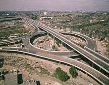
In the central London area only the East Cross Route and part of the West Cross Route of Ringway 1 were constructed together with the elevated Westway which links Paddington to North Kensington. These were all begun and completed before the plan was cancelled and, with its elevated roadway on concrete pylons flying above the streets below at roof top height, the Westway provides a good example of how much of Ringway 1 would have appeared had it been constructed.
Improvements have been made to the North Circular Road (A406) section of Ringway 2 over the decades since the plan was cancelled so that most of it is now dual carriageway. The improvements have been done in a piecemeal fashion so that the road varies in quality and capacity along its length and still has several unimproved single carriageway sections and awkward junctions. By comparison, very little has been done to improve the condition of the South Circular Road (A205) (which has complex junctions and forks) and no part of the southern part of Ringway 2 has been built, mainly because of the density of the residential areas through which the South Circular runs. The road remains predominantly single carriageway throughout.

Parts of Ringways 3 and 4 were started soon after Ringway 1 was cancelled. The first section of the northern half of Ringway 3 was constructed between South Mimms and Potters Bar and opened in 1975. The first section of Ringway 4 was built between Godstone and Reigate and opened in 1976. Before the first of these opened, the planned north and east sections of Ringway 3 and the planned south and west sections of Ringway 4 were combined as the M25 (the northern part was initially designated as the M16 during the planning stages but opened as the M25). The remaining sections of these two circular routes were never built.
Some of the radial routes that were planned to connect to the Ringway system were built much as planned, including the M1 and M4.[10][11] Other radial roads, such as the M3 or M23, were truncated in outer London far from their intended terminal junctions on Ringway 1.[12][13] Others were simply not built at all in a form recognisable from the Ringway proposal.
See also
London ring roads
Motorways
- M11 motorway – was planned to connect to the Ringways plan; eventually in the 1990s the M11 link road (part of the A12) controversially connected to the North Circular Road (see M11 link road protest)
- M12 motorway – unbuilt motorway connecting M11 and Ringways 2 and 3 with Brentwood or Chelmsford
- M15 motorway – unused motorway designation for Ringway 2
- M16 motorway – unused motorway designation for Ringway 3
- M23 motorway – was once intended to extend northwards to Ringway 2
London orbital railways
- Orbirail – unimplemented
- London Overground – operational since 9 December 2012.
References
- ↑ "Within London, a few fragments had been built: the Ringway 1 East Cross Route was complete by the early 1970s, and the A40(M) Westway and a short stub of the West Cross Route were open to traffic before the GLDP inquiry halted the plans." – Marshall, Chris. "Ringways - Background - Epilogue". CBRD. Retrieved 13 February 2009.
- ↑ "Highway Development Survey (1937)". Archived from the original on 14 May 2009.
- ↑ Marshall, Chris. "Ringways - Background - Post-war and beyond". CBRD. Retrieved 2015-05-26.
- ↑ Baily, Michael (7 January 1969). "London's Motorway Box Controversy - Investing in an Answer to More and More traffic". The Times (57452). p. 7. Retrieved 13 February 2009.
- ↑ "Ringways - Background". www.cbrd.co.uk. Retrieved 13 February 2009.
- ↑ Baily, Michael (23 October 1969). "Experts condemn London ringway scheme". The Times (57698). p. 4. Retrieved 13 February 2009.
- ↑ Baily, Michael (19 August 1970). "Road programme cost estimated at £1,700m". The Times (57948). p. 3. Retrieved 13 February 2009.
- ↑ UK CPI inflation numbers based on data available from Gregory Clark (2016), "The Annual RPI and Average Earnings for Britain, 1209 to Present (New Series)" MeasuringWorth.
- ↑ Aldous, Tony (6 June 1970). "Drastic review of Ringway 1". The Times (57889). p. 3. Retrieved 13 February 2009.
- ↑ Marshall, Chris. "Ringways - Northern Radials - M1". CBRD. Retrieved 13 February 2009.
- ↑ Marshall, Chris. "Ringways - Western Radials - M4". CBRD. Retrieved 13 February 2009.
- ↑ Marshall, Chris. "Ringways - Western Radials - M3". CBRD. Retrieved 13 February 2009.
- ↑ Marshall, Chris. "Ringways - Southern Radials - M23". CBRD. Retrieved 13 February 2009.
Gallery
 Ringway 1
 Ringway 2
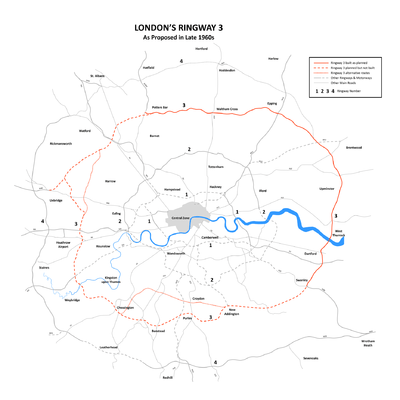 Ringway 3
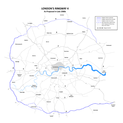 Ringway 4
External links
- cbrd.co.uk - History of the Ringways
- Pathetic Motorways - Ringways for beginners
- Unfinished London - Episode 2 - video by Jay Foreman
| Companies and organisations | |||||||||||
|---|---|---|---|---|---|---|---|---|---|---|---|
| Airports |
| ||||||||||
| Major stations | |||||||||||
| Roads |
| ||||||||||
| Ticketing | |||||||||||
| Other | |||||||||||
| Former BR sectors | |||||||||||
| |||||||||||