E postcode area
Postcode district boundaries: Bing / Google
| London E postcode area | |
|---|---|
 E | |
| Postcode area | E |
| Postcode area name | London E |
| Post towns | 1 |
| Postcode districts | 22 |
| Postcode sectors | 108 |
| Postcodes (live) | 15,920 |
| Postcodes (total) | 25,973 |
| Statistics as at February 2012[1] | |
The E (Eastern) postcode area, also known as the London E postcode area,[2] is the part of the London post town covering much of the eastern part of Greater London, England and also Sewardstone in Essex. Since the closure of the East London mail centre during the summer of 2012, inward mail for the E postcode area is now sorted at Romford Mail Centre, with the IG and RM postcode area mail.
Postal administration
The current E postcode area was originally formed in 1866 as a merger of the E and NE areas created in 1858. In 1917, the postal districts were numbered alphabetically by their location;[3] the districts usually cover a wider area than their names might suggest. As of 2004, the district names do not form part of the postal address.[2] Due to high demand, sector 9 of the E1 postcode district was split and recoded in 1999 to create an E1W postcode district around Wapping;[4] the rest of the district did not gain an additional character. Where districts are used for purposes other than the sorting of mail, such as use as a geographic reference and on street signs, E1 and E1W continue to be classed as one "district". The E postcode area contains two non-geographic postcode districts for high-volume business users, E77 and E98.[5]
The Eastern District Office is located on Whitechapel Road and was the eastern terminus for the former London Post Office Railway, which has been mothballed since 2003. The railway ran 10.5 kilometres (6.5 mi) to the Paddington Head District Sorting Office.
The E20 postcode has been used fictionally as the postcode on the television soap-opera series EastEnders. However, it became a real postcode in 2011, being created for the new Olympic Park in Stratford, site of the 2012 Summer Olympics, from within the E15 postcode.[6]
List of postcode districts
The approximate coverage of the postcode districts, with the historic postal district names shown in italics:[7][8]
| Postcode district | Post town | Coverage | Local authority area |
|---|---|---|---|
| E1 | LONDON | Eastern head district: Aldgate (part), Bishopsgate (part), Whitechapel, Shoreditch (part), Spitalfields, Shadwell, Stepney, Globe Town (part), Mile End (part), Portsoken, Brick Lane | Tower Hamlets, Hackney, City of London |
| E1W | LONDON | Wapping | Tower Hamlets |
| E2 | LONDON | Bethnal Green district: Bethnal Green, Haggerston, Hoxton, Shoreditch (part), Cambridge Heath, Globe Town (part) | Tower Hamlets, Hackney |
| E3 | LONDON | Bow district: Bow, Bromley-by-Bow, Old Ford, Mile End, Fish Island, Bow Common, Poplar (part) Limehouse (part) Three Mills, London Gas Museum | Tower Hamlets, Newham |
| E4 | LONDON | Chingford district: Chingford, Sewardstone, Highams Park, Upper Edmonton (part), Woodford Green (part) | Waltham Forest, Enfield, Epping Forest (Essex) |
| E5 | LONDON | Clapton district: Leyton (Part), Upper Clapton, Lower Clapton, Stoke Newington (part) | Hackney,Waltham Forest |
| E6 | LONDON | East Ham district: East Ham, Beckton, Upton Park (part), Barking (part) | Newham, Barking and Dagenham |
| E7 | LONDON | Forest Gate district: Forest Gate, Leytonstone (Part), Stratford (part) | Newham, Waltham Forest |
| E8 | LONDON | Hackney district: Hackney Central, Dalston, London Fields, Stoke Newington (part) | Hackney |
| E9 | LONDON | Homerton district: Homerton, Hackney Wick, South Hackney, Hackney Marshes, Victoria Park | Hackney, Tower Hamlets |
| E10 | LONDON | Leyton district: Leyton, Temple Mills, Hackney Marshes (part) Upper Clapton (part), Walthamstow Marshes | Waltham Forest, Hackney |
| E11 | LONDON | Leytonstone district: Leytonstone, Wanstead, Aldersbrook (part), Snaresbrook, Cann Hall | Waltham Forest, Redbridge |
| E12 | LONDON | Manor Park district: Manor Park, Little Ilford, Aldersbrook (part) | Newham, Redbridge |
| E13 | LONDON | Plaistow district: Plaistow, West Ham (part), Upton Park (part) | Newham |
| E14 | LONDON | Poplar district: Poplar, Isle of Dogs, Limehouse, Canary Wharf, Millwall, Blackwall, Cubitt Town, South Bromley, North Greenwich, Leamouth | Tower Hamlets |
| E15 | LONDON | Stratford district: Stratford, West Ham (part), Maryland, Leyton (part), Leytonstone (part) Temple Mills (part), Hackney Wick (part), Bow (part) | Newham, Waltham Forest, Hackney, Tower Hamlets |
| E16 | LONDON | Victoria Docks and North Woolwich district: Canning Town, Silvertown, North Woolwich, Custom House, London City Airport, Beckton (part) | Newham |
| E17 | LONDON | Walthamstow district: Walthamstow, Upper Walthamstow, Leyton (part) | Waltham Forest |
| E18 | LONDON | Woodford and South Woodford district: Woodford, South Woodford | Redbridge |
| E20 | LONDON | Olympic Park district: Olympic Park, & parts of Stratford, Homerton, Leyton, Bow; | Newham, Waltham Forest, Hackney, Tower Hamlets |
| E77 | LONDON | Non-geographic postcode district (NatWest, located in E1) | Tower Hamlets |
| E98 | LONDON | Non-geographic postcode district (News International, located in E1W) | Tower Hamlets |
Boundaries
The E1 postcode district has a River Thames frontage to the south and is central to London. Postcode districts E6, E14 and E16 also have river frontages in the south. The River Roding and the North Circular Road form part of the boundary in the east. The postcode area maps roughly to the combined area of the London Borough of Tower Hamlets, London Borough of Newham and London Borough of Waltham Forest. The eastern part of the London Borough of Hackney, western sections of the London Borough of Redbridge (E11, E12, E18) and London Borough of Barking and Dagenham (E6), and a small part of the Epping Forest district of Essex (E4) are within the postcode area.
Influences
- The 1990s pop band East 17, formed in Walthamstow, take their name from the postcode district E17.
Map
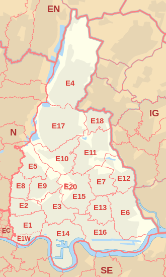
The postcode area does not cover all of the east of Greater London; the remainder is covered by the RM (Romford) and IG postcode areas. Some parts of Hackney are in the N postcode area.
See also
- Postcode Address File
- List of postcode areas in the United Kingdom
- London postal district
- North East (London sub region)
References
- ↑ "ONS Postcode Directory Version Notes" (ZIP). National Statistics Postcode Products. Office for National Statistics. February 2012. Table 2. Retrieved 21 April 2012. Coordinates from mean of unit postcode points, "Code-Point Open". OS OpenData. Ordnance Survey. February 2012. Retrieved 21 April 2012.
- 1 2 Royal Mail (2004). Address Management Guide (4 ed.). Royal Mail Group.
- ↑ "Postcodes" (PDF). Archive Information Sheet. The British Postal Museum & Archive. Retrieved 24 March 2010.
- ↑ Royal Mail, Postcode Update 29, (1999).
- ↑ "Royal Mail Non-Geographic Postcodes" (PDF). Royal Mail. 7 March 2007. Retrieved 10 March 2008.
- ↑ Staff (19 March 2011). "Olympic Park To Share EastEnders' Walford E20 Postcode". BBC News. Retrieved 19 May 2012.
- ↑ "Names of Streets and Places in the London Postal Area". HMSO. 1930.
- ↑ "Map of London District Names and Numbers", from the 1963 edition of Bartholomew's Reference Atlas of Greater London (via Flickr).