Lojsta Lakes
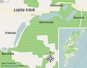
The Lojsta Lakes (Swedish: Lojstasjöarna) (sometimes referred to as the Lojsta Lake) (Gutnish: Lojsta träsk) are five lakes in Lojsta and Stånga sockens,[1] Gotland, Sweden. The names of the lakes are (west to east) Bjärsträsk, Fridträsk, Rammträsk, Slottsträsk and Broträsk. Their outflow is in the Storkanalen at Kvarnåkershamn on southweetsern Gotland. Four of the lakes are connected by manmade canals.[2] The Gutnish word for lake is träsk.[3] The Slottsträsk, the "Castle Lake", (sometimes known as Lillträsk) got its name from the Lojsta Castle, a Medieval defence-structure, situated by the lake.[4][5]
The lakes form a peculiar landscape, not found anywhere else on the island and reminiscent of the rift valleys of central Sweden with steep cliffs and deep lakes.[6] The other lakes on Gotland are very shallow, bowl-shaped depressions in the bedrock, filled with water. For example, Lake Bästeträsk is no more than 5.5 m (18 ft) at its deepest and Lake Tingstäde no more than 3 m (9.8 ft). In relation to this the Lojsta Lakes are deep, more than 10 m (33 ft) with Rammträsk as the deepest at 154 m (505 ft), making it the second deepest lake on Gotland. The deepest lake is Sigvalde träsk at 158 m (518 ft).[7][8] Lake Sigvalde is situated some kilometers east of the Lojsta Lakes, and is part of the same rift valley as them.[3]
The area around the lakes contains an unusual amount of reef limestone. This limestone was originally imbedded in sedimentary limestone, but the latter was shaved off during the latest Ice age when the inland ice sheet moved, leaving high hills of reef limestone.[9] Along the south side of the lakes is a layer of limestone which exceptionally rich in fossils.[10] Most of the cliffs formed from reef limestone have a steep, sometimes vertical, side facing north. In these cliffs (Gutnish: klintar) are small caves, the largest of which can be found at Rammträsk and Broträsk.[3]
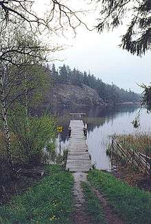
There are large stands of white waterlilies in the lakes, a plant rarely seen in Gotlandic lakes.[2] Among the fishes that can be found in the lakes are european perch, northern pike, common roach and ruffe.[11] It is possible to rent canoes and paddle through the lake system,[4] as well as purchase a fishing license for recreational fishing on the lakes. Fishing competitions are held on the lakes during the winter.[12]
The lakes
Geographical facts about the five Lojsta Lakes.[7][13]
| Name | Area | Elevation | Average depth | Maximum depth | Volume | Coordinates |
|---|---|---|---|---|---|---|
| Bjärsträsk | 0.008 km2 (0.0031 sq mi) | 45 m (148 ft) | 4.4 m (14 ft) | 11.9 m (39 ft) | 15,000 m3 (530,000 cu ft) | 57°18′43″N 18°23′25″E / 57.31194°N 18.39028°E |
| Fridträsk | 0.0883 km2 (0.0341 sq mi) | 45.1 m (148 ft) | 1.9 m (6.2 ft) | 3.3 m (11 ft) | 379,000 m3 (13,400,000 cu ft) | 57°18′57″N 18°23′57″E / 57.31583°N 18.39917°E |
| Rammträsk | 0.095 km2 (0.037 sq mi) | 39.5 m (130 ft) | 5.8 m (19 ft) | 15.4 m (51 ft) | 555,000 m3 (19,600,000 cu ft) | 57°19′9″N 18°24′23″E / 57.31917°N 18.40639°E |
| Slottsträsk | 0.101 km2 (0.039 sq mi) | 446 m (1,463 ft) | 2.8 m (9.2 ft) | 5.3 m (17 ft) | 44,000 m3 (1,600,000 cu ft) | 57°19′17″N 18°25′7″E / 57.32139°N 18.41861°E |
| Broträsk | 0.032 km2 (0.012 sq mi) | 40 m (130 ft) | 4.5 m (15 ft) | 9.5 m (31 ft) | 145,000 m3 (5,100,000 cu ft) | 57°19′7″N 18°25′8″E / 57.31861°N 18.41889°E |
References
- ↑ The border between the sockens goes straight through Ramträsk leaving 2.5 of the lakes in each socken.
- 1 2 Andersson, Gustaf (8 August 2008). "En långpromenad med armarna" [A long walk with the arms]. www.helagotland.se. Helagotland. Retrieved 2 July 2015.
- 1 2 3 Enderborg, Bernt. "Broträsk". www.guteinfo.com. Guteinfo. Retrieved 2 July 2015.
- 1 2 Ecott, Tim. "On Gotland pond". www.theguardian.com. The Guardian. Retrieved 2 July 2015.
- ↑ "Lojsta kulturstig" [Lojsta cultural trail] (PDF). www.lansstyrelsen.se. The County Administrative Boards of Gotland County. Retrieved 2 July 2015.
- ↑ Enderborg, Bernt. "Rammträsk". www.guteinfo.com. Guteinfo. Retrieved 2 July 2015.
- 1 2 "Sjödjup och sjövolym" [Depth and volume of lakes] (PDF). www.smhi.se. Swedish Meteorological and Hydrological Institute. 25 November 2009. Retrieved 2 July 2015.
- ↑ "Fakta om Gotland". www.lansstyrelsen.se. The County Administrative Boards of Gotland County. Retrieved 2 July 2015.
- ↑ Post, Lennart von (1940). Svenska Turistföreningens årsskrift 1940 Gotland. Stockholm: Svenska Turistföreningen. p. 38.
- ↑ Kloth, Jen-Henrik; Lovén, Ulf (1987). Gotlands natur: en reseguide [Gotland's nature: a travel guide]. Stockholm: Bonnier. ISBN 91-34-50860-0.
- ↑ "Fångst arter förekomst" [Occurring species]. www.slu.se. Swedish University of Agricultural Sciences. Retrieved 2 July 2015.
- ↑ Klint Langland, Eva (1 February 2010). "Segrade på Lojsta träsk" [Victorious on Lojsta Lake]. www.helagotland.se. Helagotland. Retrieved 2 July 2015.
- ↑ "Sjöareal och sjöhöjd" [Lake area and elevation] (PDF). www.smhi.se. Swedish Meteorological and Hydrological Institute. 25 November 2009. Retrieved 2 July 2015.
External links
| Wikimedia Commons has media related to Lojsta District. |
