Loikaw
| Loikaw လွိုင်ကော်မြို့ Lwègaw[1] | |
|---|---|
|
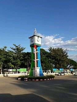
Loikaw clock tower | |
 Loikaw Location in Burma | |
| Coordinates: 19°40′27″N 97°12′34″E / 19.67417°N 97.20944°E | |
| Country |
|
| Division | Kayah State |
| District | Loikaw |
| Township | Loikaw |
| Elevation | 2,900 ft (884 m) |
| Population (2013) | 140 670 |
| Time zone | MST (UTC+6.30) |
Loikaw (Burmese: လွိုင်ကော်မြို့; MLCTS: lwing kaw mrui., pronounced: [lwàikɔ̀ mjo̰]) is the capital of Kayah State in Myanmar. It is located in the Karen Hills area, near the State's northern tip, just above an embayment on the Pilu River.[2] The inhabitants are mostly Kayah (Karenni). Myanmar's largest hydropower plant built (by the Japanese as war reparation) is located about 20 km east of Loikaw at Lawpita Falls.
History
Loikaw was the Headquarters of the Political Officer in Charge of the Karenni States, part of the Princely States of British Burma, in 1922 during British rule in Burma. The town was located in the only flat part of the Karenni area. In 1892 it numbered four huts. As an Agent of the British government he was exercising control over the local Karenni Rulers, being supervised by the Superintendent at Taunggyi.[3] The headquarters of the American Baptist Mission to Hill Karens was also located in Loikaw.
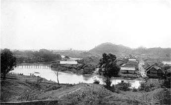 Landscape of Loikaw in 1922. The bridges look flimsy, but were so substantial that elephants walked over them. |
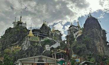 View of Taung Kwe Pagoda. |
Population history
- 1983: 33,665
- 2013: 140,670[4]
Climate
| Climate data for Loikaw | |||||||||||||
|---|---|---|---|---|---|---|---|---|---|---|---|---|---|
| Month | Jan | Feb | Mar | Apr | May | Jun | Jul | Aug | Sep | Oct | Nov | Dec | Year |
| Average high °C (°F) | 26 (79) |
29 (84) |
32 (90) |
34 (93) |
31 (88) |
28 (82) |
27 (81) |
27 (81) |
28 (82) |
28 (82) |
27 (81) |
26 (79) |
28.6 (83.5) |
| Average low °C (°F) | 11 (52) |
11 (52) |
15 (59) |
19 (66) |
20 (68) |
20 (68) |
20 (68) |
20 (68) |
20 (68) |
19 (66) |
16 (61) |
12 (54) |
16.9 (62.5) |
| Average rainfall mm (inches) | 8 (0.31) |
3 (0.12) |
7 (0.28) |
50 (1.97) |
178 (7.01) |
222 (8.74) |
251 (9.88) |
289 (11.38) |
236 (9.29) |
151 (5.94) |
51 (2.01) |
14 (0.55) |
1,460 (57.48) |
| Average rainy days | 2 | 1 | 2 | 5 | 17 | 23 | 25 | 26 | 21 | 14 | 6 | 3 | 145 |
| Mean monthly sunshine hours | 279 | 280 | 310 | 270 | 217 | 150 | 124 | 124 | 150 | 186 | 210 | 248 | 2,548 |
| Source: World Climate Guide | |||||||||||||
Transport
Loikaw is linked by the newly constructed Aungban-Pinlong-Loikaw rail line. Loikaw is also linked to Yangon by air.
Education
The town is home to Loikaw University, Technological University, Loikaw, Computer University, Loikaw.
See also
References
- ↑ "Lwègaw (Variant)" Loikaw at GEOnet Names Server, United States National Geospatial-Intelligence Agency
- ↑ Bitsch, Jørgen (1966) Why Buddha Smiles Taplinger Publishing, New York, pages 55-56, OCLC 421824
- ↑ Imperial Gazetteer of India, v. 15, p. 36.
- ↑ "City Population: Myanmar". Archived from the original on 6 October 2014.
External links
| Wikivoyage has a travel guide for Loikaw. |
 Media related to Loikaw at Wikimedia Commons
Capital: Loikaw | ||
| Bawlakhe District |
|  |
| Loikaw District | ||
| Main cities and towns | ||
Coordinates: 19°40′27″N 97°12′33″E / 19.67417°N 97.20917°E