Lohja
| Lohja Lohja – Lojo | ||
|---|---|---|
| Town | ||
| Lohjan kaupunki – Lojo stad | ||
|
Laurinkatu street in central Lohja | ||
| ||
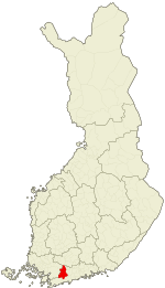 Location of Lohja in Finland | ||
| Coordinates: 60°15′N 024°04′E / 60.250°N 24.067°ECoordinates: 60°15′N 024°04′E / 60.250°N 24.067°E | ||
| Country | Finland | |
| Region | Uusimaa | |
| Sub-region | Helsinki sub-region | |
| Charter | 1926 | |
| City rights | 1969 | |
| Government | ||
| • Town manager | Simo Juva | |
| Area (2011-01-01)[1] | ||
| • Total | 441.19 km2 (170.34 sq mi) | |
| • Land | 349.41 km2 (134.91 sq mi) | |
| • Water | 91.78 km2 (35.44 sq mi) | |
| Area rank | 242nd largest in Finland | |
| Population (2016-03-31)[2] | ||
| • Total | 47,241 | |
| • Rank | 25th largest in Finland | |
| • Density | 135.2/km2 (350/sq mi) | |
| Population by native language[3] | ||
| • Finnish | 93.6% (official) | |
| • Swedish | 4% (official) | |
| • Others | 2.4% | |
| Population by age[4] | ||
| • 0 to 14 | 18.7% | |
| • 15 to 64 | 66.4% | |
| • 65 or older | 14.9% | |
| Time zone | EET (UTC+2) | |
| • Summer (DST) | EEST (UTC+3) | |
| Municipal tax rate[5] | 19.5% | |
| Urbanisation | 89.7% | |
| Unemployment rate | 8.4% | |
| Climate | Dfb | |
| Website | www.lohja.fi | |

Lohja (Finnish pronunciation: [ˈlohjɑ]; Swedish: Lojo) is a town and municipality of Finland.
It is located in the province of Southern Finland and is part of the Uusimaa region. The town has a population of 47,518 (31 March 2016)[2] and covers an area of 441.19 square kilometres (170.34 sq mi) of which 91.78 km2 (35.44 sq mi) is water.[1] The population density is 135.2 inhabitants per square kilometre (350/sq mi). The municipality is bilingual, although it is not required by law, with the majority being Finnish and minority Swedish speakers.[3]
Lohja has been a focal point for the population and economy of Western Uusimaa since the early 14th century. It was renowned as a trading centre in the Middle Ages. The local inhabitants were among the pioneers of the Finnish mining and construction material industries. By Finnish standards, Lohja has long-established traditions in horticulture and especially in market gardening. These traditions are represented by the symbols of present-day Lohja: limestone and an apple.
Lohja is advantageously located near the Helsinki Metropolitan Area, and it benefits from a good road network. It takes less than an hour to drive from Helsinki to Lohja.
The landscape of Lohja is characterized by manors and gardens. Its area is divided by the Lohja ridge, which forms a watershed for the largest lake system of Southern Finland, Lohjanjärvi. The medieval St. Lawrence church is the architectural highlight of the downtown area, which also includes a heterogeneous mix of buildings mostly dating from the 1960s onwards. The new Lohja Library, opened in 2005, is a distinctly modern building placed in the very centre of the town.
The municipality of Lohjan kunta was consolidated with Lohja in 1997, and the municipality of Sammatti was consolidated with Lohja in 2009. The municipalities of Karjalohja and Nummi-Pusula were consolidated with Lohja in 2013.
Politics
Results of the Finnish parliamentary election, 2011 in Lohja:
- Social Democratic Party 24.9%
- True Finns 23.9%
- National Coalition Party 21.4%
- Left Alliance 8.7%
- Centre Party 7.0%
- Green League 6.7%
- Christian Democrats 3.2%
- Swedish People's Party 3.0%
Culture
Lohja is famed for its cultural events. More than a hundred different events are arranged in the town each year by its residents and organizations. The most notable are the Lohja Summer Cultural Festival, the Apple Carnival organized by representatives of business and commerce, the retailers' Hurlumhei Carnival and the Old Time Christmas market continue the tradition of fairs dating back to the Middle Ages.
The Doom Metal band Reverend Bizarre is from this town.
Sights
One unique experience is the Tytyri limestone mine, which has a museum 100 metres underground. This attraction and exhibitions can be reached using either an old mine wagon or a modern lift.[6] Other places of note are:
- Lohja museum area
- The surroundings of Lake Lohja
- The Gothic Church of St. Lawrence which dates from the 15th century
- Kisakallio Sport college
- Floating Restaurant-Café Kaljaasi
- Alitalo vineyard
- St. Lawrence Golf and the recreation bath Neidonkeidas
International relations
Twin towns — Sister cities
Lohja is twinned with:
-
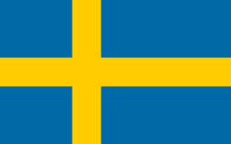 Växjö, Sweden
 -
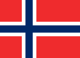 Ringerike, Norway
 -
 Aabenraa, Denmark
 -
 Skagaströnd, Iceland
 -
 Sátoraljaújhely, Hungary
Gallery
 The new Lohja Library opened in 2005
 Lohja St. Lawrence church
References
- 1 2 "Area by municipality as of 1 January 2011" (PDF) (in Finnish and Swedish). Land Survey of Finland. Retrieved 9 March 2011.
- 1 2 "Ennakkoväkiluku sukupuolen mukaan alueittain, maaliskuu.2016" (in Finnish). Statistics Finland. Retrieved 31 March 2016.
- 1 2 "Population according to language and the number of foreigners and land area km2 by area as of 31 December 2008". Statistics Finland's PX-Web databases. Statistics Finland. Retrieved 29 March 2009.
- ↑ "Population according to age and gender by area as of 31 December 2008". Statistics Finland's PX-Web databases. Statistics Finland. Retrieved 28 April 2009.
- ↑ "List of municipal and parish tax rates in 2011". Tax Administration of Finland. 29 November 2010. Retrieved 13 March 2011.
- ↑ Tytyri Mine Museum
External links
 Media related to Lohja at Wikimedia Commons
- Town of Lohja – Official site
| Municipalities |  | |
|---|---|---|
| Former municipalities |
| |