Logging Lake
| Logging Lake | |
|---|---|
 Logging Lake | |
| Location | Glacier National Park, Flathead County, Montana, US |
| Coordinates | 48°45′11″N 114°05′19″W / 48.75306°N 114.08861°WCoordinates: 48°45′11″N 114°05′19″W / 48.75306°N 114.08861°W[1] |
| Type | Natural |
| Primary inflows | Logging Creek |
| Primary outflows | Logging Creek |
| Basin countries | United States |
| Max. length | 6 mi (9.7 km) |
| Max. width | .40 mi (0.64 km) |
| Surface elevation | 3,810 ft (1,160 m) |
Logging Lake is located in Glacier National Park, in the U. S. state of Montana. Logging Lake is one of the longest lakes in Glacier National Park at 6 miles (9.7 km) in length.[2] The Lower Logging Lake Snowshoe Cabin and Boathouse are two structures located near the southwestern end of Logging Lake, and are on the National Register of Historic Places. Logging Lake is a 4.5 miles (7.2 km) hike from the Logging Lake Ranger Station.[3]
Glacier View Dam, proposed in the 1940s, would have raised the surface of Logging Lake by as much as 50 feet (15 m) while inundating lands to the west of the lake. The dam was never built.[4]
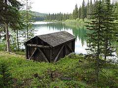
Lower Logging Lake Boathouse
See also
List of lakes in Flathead County, Montana (A-L)
References
- ↑ "Logging Lake". Geographic Names Information System. United States Geological Survey. Retrieved 2011-02-27.
- ↑ "Vulture Peak, MT" (Map (USGS Quad)). TopoQuest. Retrieved 2011-02-27.
- ↑ "Day Hikes in Glacier" (pdf). Plan Your Visit. National Park Service. Retrieved 2011-02-27.
- ↑ Buchholtz, C.W. (1976). "Chapter 6:Guardians of Glacier". Man in Glacier. Glacier Natural History Association. ISBN 0-916792-01-3. Retrieved 4 June 2011.
This article is issued from Wikipedia - version of the 1/31/2015. The text is available under the Creative Commons Attribution/Share Alike but additional terms may apply for the media files.