Lofa County
| Lofa County | ||
|---|---|---|
| County | ||
| ||
| Nickname(s): Tambah Nyumah | ||
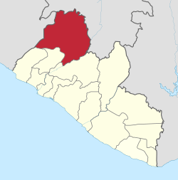 Location in Liberia | ||
| Coordinates: 7°55′N 10°0′W / 7.917°N 10.000°WCoordinates: 7°55′N 10°0′W / 7.917°N 10.000°W | ||
| Country |
| |
| Capital | Voinjama | |
| Districts | 6 | |
| Established | 1964 | |
| Government | ||
| • Superintendent | George Dunor | |
| Area | ||
| • Total | 9,982 km2 (3,854 sq mi) | |
| Population (2008) | ||
| • Total | 276,863 | |
| • Density | 27.1/km2 (70/sq mi) | |
| Time zone | GMT (UTC+0) | |
Lofa is a county in the northernmost portion of Liberia. One of 15 counties that constitute the first-level of administrative division in the nation, it has six districts. Voinjama serves as the capital with the area of the county measuring 9,982 square kilometres (3,854 sq mi).[1] As of the 2008 Census, it had a population of 276,863, making it the fourth most populous county in Liberia.[1]
Lofa's County Superintendent is George Dunor.[2] The county is bordered by Bong County to the south and Gbarpolu County to the west. The northwestern parts of Lofa border the nation of Sierra Leone and the northeastern parts border Guinea. Mount Wuteve, the highest mountain in Liberia, lies in the north-central part of the county.
History
Many people left the area as refugees in 1999 and the early 2000s as it became a main focus of fighting during the Liberian civil war. The Red Cross said that in January 2004 many people had begun to return from refugee camps in neighbouring Guinea and Sierra Leone. At that time the county's population was estimated to be 34,310.[3] The largest city and county capital is Voinjama with a population of 4,945. Foya is the second largest city (population 1,760). Lofa produced one of the nations most respected leaders in the late vice president Dr. Harry F. Moniba who served from 1984 - 1990.[4]
Geography

The Western part of the county has coastal plains that raises to a height of 30 m (98 ft) above the sea-level inward to a distance of 25 km (16 mi). These plains receive a very high rainfall ranging from 4,450 mm (175 in) to 4,500 mm (180 in) per year and receive longer sunshine with a humidity of 85 to 95 per cent. It is swampy along rivers and creeks, while there are patches of Savannah woodland. Rice and cassava interplanted with Sugarcane are the major crops grown in the region.[5] Lofa County has a community forest, the Bluyeama, occypying an area of 44,444 ha (109,820 acres). It has three National proposed reserves, namely the Wologizi Mountain (99,538 ha (245,960 acres)), Wonegizi Range (37,979 ha (93,850 acres)) and Foya Forest (164,628 ha (406,800 acres)). It has the Foya Afforestation Project with an area of 9,062.4 hectares (22,394 acres), which is designated as a National Plantation area.[6]
Demographics
As of 2008, the county had a population of 276,863, comprising of 133,611 males and 143,252 females. The sex ratio was 93.3 compared to 107.8 in 1994 census.[7] The number of households during 2008 was 45,095 and the average size of the households was 5.5.[8] The population was 9.50 per cent of the total population, while it was 8.00 per cent in 1994. The county had an area of 3,854 sq mi and the density per sq.mi was 72. The density during the 1984 census stood at 52.[1] Liberia experienced civil war during various times and the total number of people displaced on account of wars as of 2008 in the county was 128,178.[9] The number of people residing in urban areas was 83,150, with 40,592 males and 42,558 females. The total number of people in rural areas was 193,713, with 93,019 males and 100,694 females. The total fraction of people residing in urban areas was 30.03 per cent, while the remaining 070 per cent were living in rural areas. The number of people resettled as of 2008 was 32,959 while the number of people who were not resettled was 13,399.[10] The number of literates above the age of ten as of 2008 was 79,196 while the number of illiterates was 66,907 making the literacy rate to 54.21. The total number of literate males was 47,865 while the total number of literate females was 31,331.[8]
Economy
As of 2011, the area of rice plantation was 40,500 ha (100,000 acres), which was 16.961 per cent of the total area of rice planted in the country. The total production stood at 8570 metric tonnes. As of 2011, the number of Cassava plantation was 9090, which was 7.4 per cent of the total area of Cassava planted in the country. The total production stood at 11250 metric tonnes. The number of Cocoa plantation was 11250, which was 29.1 per cent of the total area of Cassava planted in the country. The number of rubber plantation was 810, which was 1.3 per cent of the total area of Cassava planted in the country. The number of Coffee plantation was 11000, which was 49.3 per cent of the total area of Cassava planted in the country.[11] As of 2008, the county had 4,323 paid employees, 38,287 self-employed people, 73,046 family workers, 4,565 people looking for work, 6,048 not working people, 23,682 people working in households, 40,653 students, 606 retired people, 4,951 incapacitated people, 1,582 part-time workers and 24,418 others, making the total working population of 222,161.[12]
Administration
Districts of Lofa County include (2008 population):Foya District (100,000), Kolahun District (59,057),Salayea District (22,968), Vahun District (16,876), Voinjama District (40,730), and Zorzor District (40,352).[1] The Legislature of Liberia was modeled based on the Legislature of United States. It is bicameral in nature with a Senate and the House of Representatives. There are 13 counties in the country and based on the population, each county is defined to have at least two members, while the total number of members to the house including the Speaker being 64. Each member represents an electoral district and elected to a six year term based on popular vote.[13] There were 26 senators, two each for the 13 counties and they serve a nine year term (30 senators, 15 counties and nine years from 2011). Senators are also elected based on plurality of votes. The Vice-President is the head of the Senate and he also acts as President in his absence.[13]
Notes
- 1 2 3 4 2008 Population and Housing census, p. 10
- ↑ "New 'One UN' office opens in northern Liberia to advance UN effectiveness in planning, coordination and programming". UNMIL. 7 June 2008. Retrieved 2008-10-14.
- ↑ "Red Cross estimates of Lofa County populations January 2004". Humanitarin Organization. Archived from the original on 29 September 2007. Retrieved 9 November 2016.
- ↑ Dunn, Elwood D.; Beyan, Amos J.; Burrowes, Carl Patrick (2000). Historical Dictionary of Liberia. Scarecrow Press. p. 147. ISBN 9781461659310.
- ↑ "Liberia - Country pastures and forage resource profile". Food and Agricultural Organization. Retrieved 9 September 2016.
- ↑ National Forests Classification, Acreages, Location And Utilization Index Division Of Scientific Research (PDF) (Report). Forest Research and Development (R&D). Retrieved 8 November 2016.
- ↑ 2008 Population and Housing census, p. A12 - 16
- 1 2 2008 Population and Housing census, pp. A47-51
- ↑ 2008 Population and Housing census, pp. A21-31
- ↑ 2008 Population and Housing census, pp. A26-31
- ↑ "Plantation statistics of Liberia". Liberia Institute of Statistics & Geo-Information Services. Retrieved 9 November 2016.
- ↑ 2008 Population and Housing census, p. 154
- 1 2 "About The Republic Of Liberia – Politics". Ministry of Information, Government of Liberia. 2014. Retrieved 23 October 2016.
References
- "2008 Population and Housing Census, final results" (PDF). Monrovia, Liberia: Liberia Institute of Statistics and Geo-information Services. 2009.