Lock and Dam No. 15
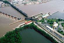 Lock and Dam No. 15 on the Mississippi River. View is from the Illinois side of the river looking across to Davenport, Iowa. | |
| Location | Rock Island, Illinois / Davenport, Iowa |
|---|---|
| Coordinates | 41°31′07″N 90°34′08″W / 41.51861°N 90.56889°WCoordinates: 41°31′07″N 90°34′08″W / 41.51861°N 90.56889°W |
| Construction began | 1931 |
| Opening date | March 7, 1934 |
| Operator(s) | United States Army Corps of Engineers |
| Dam and spillways | |
| Impounds | Upper Mississippi River |
| Length | 1,203 feet (366.7 m) |
| Reservoir | |
| Creates | Pool 15 |
| Total capacity | 100,000 acre·ft (0.12 km3) |
| Catchment area | 88,500 sq mi (229,000 km2) |
|
Lock and Dam No. 15 Historic District | |
  | |
| Location | NW of Rodman Ave., Twd., NW tip Arsenal Island, Rock Island, Illinois |
| Area | 359 acres (145 ha) |
| Built | 1895 |
| Architectural style | Other, Lock and Dam |
| MPS | Upper Mississippi River 9-Foot Navigation Project MPS |
| NRHP Reference # | 04000175[1] |
| Added to NRHP | March 10, 2004 |
Lock and Dam No. 15 is a lock and dam located on the Upper Mississippi River. It spans the river between Rock Island, Illinois and Davenport, Iowa. Lock and Dam 15 is the largest roller dam in the world, its dam is 1,203 feet (366.7 m) long and consists of nine 109 feet (33.2 m) non-submersible, non-overflow roller gates and two 109 feet (33.2 m) non-submersible overflow roller gates. It is unusual among the upper Mississippi River dams in that it has only roller gates, has different sizes and types of roller gates, it is not perpendicular to the flow of the river and is one of the few facilities that has a completed auxiliary lock. The main lock is 110 feet (33.5 m) wide by 600 feet (180 m) long and its auxiliary lock is 110 feet (34 m) wide by 360 feet (110 m) long.[2] In 2004, the facility was listed in the National Register of Historic Places as Lock and Dam No. 15 Historic District, #04000175 covering 3,590 acres (1,450 ha), 2 buildings, 9 structures, and 1 object.
See also
- Government Bridge, passes near the locks.
- Rock Island Arsenal adjacent to the locks.
References
- ↑ National Park Service (2010-07-09). "National Register Information System". National Register of Historic Places. National Park Service.
- ↑ "Locks & Dam 15" (PDF). U.S. Army Corps of Engineers. Retrieved January 5, 2014.
External links
- Mississippi River Visitor Center Locks & Dam 15
- Historic American Engineering Record (HAER) No. IL-27, "Mississippi River 9-Foot Channel Project, Lock & Dam No. 15, Upper Mississippi River (Arsenal Island), Rock Island, Rock Island County, IL"
- US Army Corp of Engineers LD 15 Cam 2 – Live camera of Lock & Dam 15, picture updated every 60 seconds

| Locks and dams of the Upper Mississippi River | ||
|---|---|---|
| Upstream: Lock and Dam No. 14 |
Downstream: Lock and Dam No. 16 | |
| Topics | |
|---|---|
| Lists by states |
|
| Lists by insular areas | |
| Lists by associated states | |
| Other areas | |
| |