Llanquihue Province
| Llanquihue Province Provincia de Llanquihue | ||
|---|---|---|
| Province | ||
|
Llanquihue Lake and the Osorno Volcano | ||
| ||
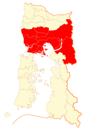 Location in the Los Lagos Region | ||
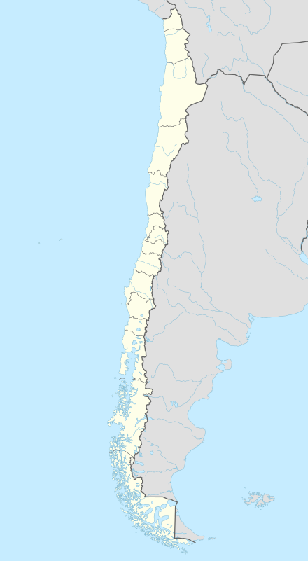 Llanquihue Province Location in Chile | ||
| Coordinates: 41°20′S 72°50′W / 41.333°S 72.833°WCoordinates: 41°20′S 72°50′W / 41.333°S 72.833°W | ||
| Country | Chile | |
| Region | Los Lagos | |
| Capital | Puerto Montt | |
| Communes | ||
| Government | ||
| • Type | Provincial | |
| • Governor | Francisco Le-Bretón | |
| Area[1] | ||
| • Total | 14,876.4 km2 (5,743.8 sq mi) | |
| Population (2012 Census)[1] | ||
| • Total | 368,127 | |
| • Density | 25/km2 (64/sq mi) | |
| • Urban | 232,962 | |
| • Rural | 88,531 | |
| Sex[1] | ||
| • Men | 162,636 | |
| • Women | 158,857 | |
| Time zone | CLT [2] (UTC-4) | |
| • Summer (DST) | CLST [3] (UTC-3) | |
| Area code(s) | 56 + 65 | |
| Website | Government of Llanquihue | |
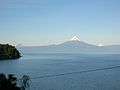

Llanquihue Province (Spanish: Provincia de Llanquihue) is one of four provinces of the Chilean region of Los Lagos (X). Its capital is Puerto Montt. Chile's second largest lake, Lake Llanquihue, is located in the province as well as four volcanoes: Osorno, Calbuco, Puntiagudo and Cerro Tronador.
European settlement of Llanquihue began in 1852 when Germans were encouraged to immigrate to southern Chile. A century later in 1945 a new wave of Jewish refugees came from Germany.[4]
The region is well known for the beauty of its natural environment as well as for the food and seafood from the ports of Puerto Montt and Calbuco.
Administration
As a province, Llanquihue is a second-level administrative division of Chile, governed by a municipality for each constituent commune (Spanish: comuna). Puerto Montt is the provincial capital. The provincial governor is Francisco Le-Bretón as appointed by the President of Chile.
Communes
Geography and demography
According to the 2002 census by the National Statistics Institute (INE), the province spans an area of 14,876.4 km2 (5,744 sq mi)[1] and had a population of 321,493 inhabitants (162,636 men and 158,857 women), giving it a population density of 21.6/km2 (56/sq mi). Of these, 232,962 (72.5%) lived in urban areas and 88,531 (27.5%) in rural areas. Between the 1992 and 2002 censuses, the population grew by 22.4% (58,931 persons).[1]
Cities
References
- 1 2 3 4 5 "Territorial division of Chile" (PDF) (in Spanish). National Statistics Institute. 2007. Retrieved 23 March 2011.
- ↑ "Chile Time". WorldTimeZones.org. Retrieved 2010-07-28.
- ↑ "Chile Summer Time". WorldTimeZones.org. Retrieved 2010-07-28.
- ↑ (Spanish) Colonización alemana en Llanquihue
