South Stoke, Oxfordshire
| South Stoke | |
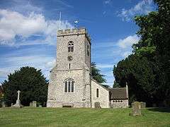 St. Andrew's parish church |
|
 South Stoke |
|
| Area | 7.68 km2 (2.97 sq mi) |
|---|---|
| Population | 458 (parish, including Littlestoke) (2001 census)[1] |
| – density | 60/km2 (160/sq mi) |
| OS grid reference | SU6083 |
| Civil parish | South Stoke |
| District | South Oxfordshire |
| Shire county | Oxfordshire |
| Region | South East |
| Country | England |
| Sovereign state | United Kingdom |
| Post town | Goring-on-Thames |
| Postcode district | RG8 |
| Dialling code | 01491 |
| Police | Thames Valley |
| Fire | Oxfordshire |
| Ambulance | South Central |
| EU Parliament | South East England |
| UK Parliament | Henley |
| Website | South Stoke village |
|
|
Coordinates: 51°32′49″N 1°08′06″W / 51.547°N 1.135°W
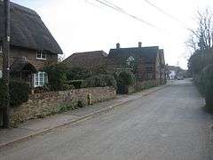
South Stoke is a village and civil parish on an east bank of the Thames, about 1.5 miles (2.4 km) north of Goring-on-Thames in South Oxfordshire. It includes less than 1 mile (1.6 km) to its north the hamlet and manor house of Littlestoke (aka Stoke Marmion).
Manor
In AD 975 King Edgar granted Osweard land at Stoke, probably later the South Stoke and Offham manors.
The manor passed to Eynsham Abbey in 1094.[2] At the time of the Hundred Rolls in 1279, South Stoke had 40 tenants and only three freeholders.[2] Woodcote, 3 miles (5 km) east of South Stoke, had developed as a dependent settlement by 1109.[2] It was followed by Exlade Street by 1241 and Greenmoor by 1366.[2]
Churches
The Church of England parish church of Saint Andrew was built in the 13th century and still has Early English Gothic features including the three-bay arcade between the nave and the north aisles, windows in the north wall of the chancel and the east and west ends of the south and north aisle.[3] The east window of the south aisle has late 13th century stained glass of the Virgin and Child.[4]
In the 14th century the present font was carved,[4] a new chancel arch was built and new windows were inserted in the east and south walls of the chancel and the north and south walls of the nave.[3] The west tower is a Perpendicular Gothic addition.[4] In 1857 the church was restored, the south arcade was rebuilt and south aisle was widened.[3] The architect for these works was J.B. Clacy of Reading.[5]
The Vicarage was designed by the Gothic Revival architect Charles Buckeridge and built in 1869.[4]
In 1820 a chapel was built for the Countess of Huntingdon's Connexion.[4] It is now a private house.[6]
Economy and society
Isambard Kingdom Brunel built Moulsford Railway Bridge in 1839-40.[4]
South Stoke has a public house, the Perch and Pike.[7]
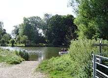
The Ridgeway path runs through the village to access its ferry to Moulsford which is seasonal.
Localities
Littlestoke
51°33′43″N 1°08′02″W / 51.562°N 1.134°W
Littlestoke is a hamlet on the River Thames sometimes seen in texts as Little Stoke.[8]
Littlestoke is on the old road that linked Wallingford and Reading via Goring Heath.
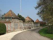
Littlestoke has a manor house, still a farmhouse with a smaller estate than previously, which has three outlying associated barns, listed for their architecture.[9]
A ferryman until at least 1920 used to be available to cross the Thames to Cholsey.[8] The Ridgeway path runs past the site of the ferry, however now a minor detour is necessary along the national long-distance footpath to South Stoke itself and then north from Moulsford on the opposite bank. As mentioned the South Stoke ferry is seasonal.
Between the two, downstream is Moulsford Railway Bridge.
Public Transport
From 6 June 2012, South Stoke is served by Go Ride bus service number 134 from Wallingford to Goring-on-Thames.[10]
References
- ↑ "Area: South Stoke CP (Parish): Parish Headcounts". Neighbourhood Statistics. Office for National Statistics. Retrieved 20 March 2010.
- 1 2 3 4 Emery, 1974, page 96
- 1 2 3 Sherwood & Pevsner, 1974, page 773
- 1 2 3 4 5 6 Sherwood & Pevsner, 1974, page 774
- ↑ Brodie, Felstead, Franklin & Pinfield, 2001, page 375
- ↑ "Oxfordshire Churches & Chapels website: South Stoke". Oxfordshirechurches.info. Retrieved 6 June 2012.
- ↑ "The Perch and Pike". The Perch and Pike. Retrieved 6 June 2012.
- 1 2 Thacker, Fred. S. (1968) [1920]. The Thames Highway: Volume II Locks and Weirs. Newton Abbot: David & Charles. pp. 202–204.
- ↑ Barns Historic England. "Details from listed building database (1059266)". National Heritage List for England. Retrieved 9 June 2013. Historic England. "Details from listed building database (1059266)". National Heritage List for England. Retrieved 9 June 2013. Historic England. "Details from listed building database (1193900)". National Heritage List for England. Retrieved 9 June 2013.
- ↑ "timetables & fares". Goridebus.co.uk. Retrieved 6 June 2012.
Sources
- Brodie, Antonia; Felstead, Alison; Franklin, Jonathan; Pinfield, Leslie; Oldfield, Jane, eds. (2001). Directory of British Architects 1834–1914, A–K. London & New York: Continuum. p. 375. ISBN 0-8264-5513-1.
- Emery, Frank (1974). The Oxfordshire Landscape. The Making of the English Landscape. London: Hodder & Stoughton. p. 96. ISBN 0-340-04301-6.
- Lobel, Mary D, ed. (1962). A History of the County of Oxford: Volume 7: Thame and Dorchester Hundreds. Victoria County History. pp. 93–112.
- Sherwood, Jennifer; Pevsner, Nikolaus (1974). Oxfordshire. The Buildings of England. Harmondsworth: Penguin Books. pp. 773–774. ISBN 0-14-071045-0.
External links
![]() Media related to South Stoke, Oxfordshire at Wikimedia Commons
Media related to South Stoke, Oxfordshire at Wikimedia Commons
