Lithuania proper
Part of a series on the |
|---|
| History of Lithuania |
 |
| Chronology |
|
|

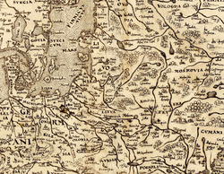
Lithuania proper (Latin: Lithuania propria; Lithuanian: Didžioji Lietuva, literally: "Genuine Lithuania"; Yiddish: ליטע, Lite) refers to a region which existed within the Grand Duchy of Lithuania, and where the Lithuanian language was spoken.[1] The primary meaning is identical to the Duchy of Lithuania, a land around which the Grand Duchy of Lithuania evolved. The territory can be traced by Catholic Christian parishes established in pagan Baltic lands of the Grand Duchy of Lithuania subsequent to the Christianization of Lithuania in 1387. They were quite distinguishable, since Ruthenian parts of the Duchy were already baptised in an orthodox manner.[2][3] The term in Latin was widely used during the Middle Ages and can be found in numerous historical maps until World War I.
Lithuania proper sometimes is also called Lithuania Major (Lithuanian: Didžioji Lietuva), particularly in contrast with Lithuania Minor.
Evolution of the term
Before the Grand Duchy of Lithuania
Historians designate Lithuania Proper (or Land of Lithuania in a narrow sense) as a Lithuanian land that existed prior to Grand Duchy of Lithuania, near other lands: Land of Nalšia, Land of Deltuva, Land of Upytė. According to Henryk Łowmiański Lithuania Proper was in nucleus of future Trakai Voivodeship between rivers: Nemunas, Neris and Merkys. Tomas Baranauskas suggests[4] that Lithuania Proper was around Ashmyany area, then ethnic Lithuanian lands now in Belarus. According to Mikola Yermalovich (although his reliability is questioned by other scholars[5][6]) Lithuania (Belarusian: Летапiсная Лiтва, literary: Lithuania of chronicles) was in the upper Neman region,[7][8] now in modern Belarus.
In the Grand Duchy of Lithuania
.png)
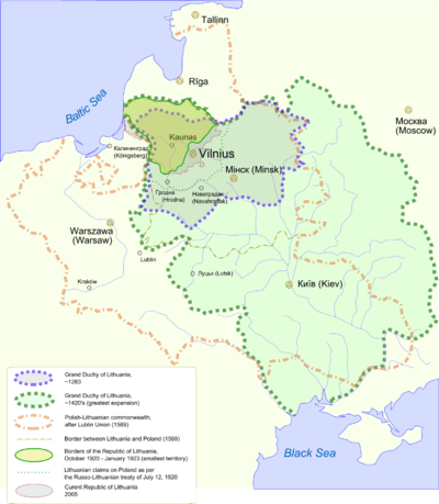
Scholars often use term Lithuania proper to refer to lands inhabited by ethnic Lithuanians[9] as opposed to lands controlled by the Grand Duchy of Lithuania inhabited by Ruthenians (ancestors of modern Belarusians and Ukrainians), Russians, Poles, Lithuanian Jews or many other nationalities. Already during the Grand Duchy times, Lithuania Proper was a term designated to land where Lithuanians live.[10] Administratively it consisted of Vilnius Voivodeship and Trakai Voivodeship.[11] Such division existed even after Polish-Lithuanian Commonwealth was partitioned.[12] Thus Grand Duchy of Lithuania was divided into such historical regions: Samogitia, Lithuania Proper and White Ruthenia.[13]
Only the northern border of Lithuania proper can be determined indefinitely. The present border between Lithuania and Latvia is the oldest national border in Europe and has not changed since the battle of Saule in 1236 and the subsequent merger of the Livonian Brothers of the Sword and the Teutonic order.
Eastern part of Lithuania Propria
For centuries, eastern and southern lands of this territory, that had direct contacts with Ruthenia and Poland, initially inhabited by ethnic Lithuanians were slowly Ruthenised, Polonised and Russified, and the Lithuanian-speaking territory shrunk. Eastern parts of Lithuania Propria suffered heavy population losses during the Deluge, and further on during the Great Northern War and following plague epidemic in 1710-1711. Subsequent immigration of Ruthenians and Poles into these territories accelerated the process. A significant push to the de-Lithuanisation ensued when Lithuania became a part of the Russian Empire, and especially, after Lithuanian language books were forbidden to print in Latin letters in 1864. The process continued at the time of Polish rule, as Lithuanian language schools and libraries were closed, and later under Soviet rule, as no Lithuanian schools were in these territories at all. Nowadays significant "islands" of Lithuanian-speaking people remain in what is now Western Belarus (see Gerviaty) and Northern Poland (see Punsk). Many people of these territories now speaking Belarusian still refer to themselves as Lithuanians.[14]
Modern developments
At the end of World War I, the Council of Lithuania declared that an independent Lithuanian state is re-established in the ethnic Lithuanian lands.
After negotiations with Bolshevik Russia a large part of Lithuania Proper was acknowledged by Soviets as part of Lithuanian Republic by signing the Soviet-Lithuanian Treaty of 1920. Some of these territories were also claimed by Second Republic of Poland. This led to series of military conflicts and eventually to war.
In 1943, Antanas Smetona (in exile at the time) began working on a study "Lithuania Propria".[15] The book was dedicated to the history of Lithuanian lands before Polonisation, Russification, and Germanisation hoping that it would help to substantiate a claim to unreturned territories in a peace conference after World War II. His work was left unfinished, and for a long time was available only as a manuscript and was virtually unknown.[16]
Currently the Republic of Lithuania has no territorial claims.
See also
Notes
- ↑ Stone. Polish-Lithuanian state, 1386-1795. p.4
- ↑ Гаучас П. К вопросу о восточных и южных границах литовской этнической территории в средневековье // Балто-славянские исследования. 1986. М., 1988. С. 195, 196.
- ↑ Safarewicz J. Studia językoznawcze. Warszawa, 1967. S. 257-259
- ↑ Baranauskas, Tomas (2002). "Kur buvo Lietuvos žemė?" (PDF). Lituanistica. 2: 3–18.
- ↑ Gudavičius, Edvardas (1996). "Following the Tracks of a Myth". Lithuanian Historical Studies. 1: 38–58.
- ↑ Насевіч В.Л. Працэс утварэння Вялікага княства Літоўскага (13-14 стст.) // Актуальныя пытанні гісторыі Беларусі ад старажытных часоў да нашых дзён. Мн., 1992. С. 54-63.
- ↑ Виктор Верас. "Карта летапiснай Лiтвы". Retrieved 2010-10-05. (Belarusian)
- ↑ Виктор Верас. "У истоков исторической правды / Летописи о местонахождении Литвы". Retrieved 2010-10-05. (Russian)
- ↑ Venclova, Tomas. "Native Realm Revisited: Mickiewicz's Lithuania and Mickiewicz in Lithuania". Retrieved 2007-04-24.
- ↑ Ochmański, Jerzy (1981). Litewska granica etniczna na wschodzie od epoki plemiennej do XVI wieku (in Polish). Wydawn. Nauk. Uniwersytetu im. Adama Mickiewicza. pp. 69–73. Retrieved 2006-04-26.
- ↑ (Lithuanian) Viduramžių Lietuva Viduramžių Lietuvos provincijos. Retrieved on 2007.04.11
- ↑ Authentic maps showing Lithuania Propria:
"Poloniae Regnum ut et Magni Ducatus Lithuaniae Accuratiss" (PDF). Retrieved 2007-04-22.
"Poloniae Regnum ut et Magni Ducatus Lithuaniae Accuratiss" (PDF). Retrieved 2007-04-22. - ↑ Authentic map showing Lithuania Proper and adjustant White ( or Lithuanian) Ruthenia:
"Carte des Estats de Suede , de Dannemarq, et de Pologne ; sur la Mer Baltique". 1700. Retrieved 2007-08-17. - ↑ Savukynas, Viriginijus (2003). "Etnokonfesiniai Santykiai Pietryčių Lietuvoje Istorinės Antropologijos Aspektu". Kultūrologija. 10: 80–98.
- ↑ Smetona, Antanas. "Lithuania Propria". Darbai ir dienos (in Lithuanian). 2 (11): 191–234.
- ↑ Aleksandravičius, Egidijus. "Istorija ir politika". Darbai ir dienos (in Lithuanian). 2 (11): 185–190.
External links
- The map of the ethnic groups of the eastern Poland in 1921, after Norman Davies, God's Playground: A History of Poland: Volume II, 1795 to the Present; Columbia University Press: 1982
Coordinates: 55°N 25°E / 55°N 25°E
Lithuania articles | ||||||||||||||||
|---|---|---|---|---|---|---|---|---|---|---|---|---|---|---|---|---|
| History |
| | ||||||||||||||
| Geography | ||||||||||||||||
| Politics |
| |||||||||||||||
| Economy | ||||||||||||||||
| Society |
| |||||||||||||||
| ||||||||||||||||