Litchfield (borough), Connecticut
| Litchfield | |
| Borough | |
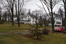
 First Congregational Church, at center of borough | |
| Country | United States |
|---|---|
| State | Connecticut |
| Region | Litchfield Hills |
| Town | Litchfield |
| Landmark | Litchfield Historic District |
| River | Bantam |
| Center | First Congregational Church |
| - elevation | 1,060 ft (323 m) |
| - coordinates | 41°44′51″N 73°11′17″W / 41.74750°N 73.18806°WCoordinates: 41°44′51″N 73°11′17″W / 41.74750°N 73.18806°W |
| Highest point | NW borough corner |
| - elevation | 1,160 ft (354 m) |
| - coordinates | 41°45′17″N 73°11′59″W / 41.75472°N 73.19972°W |
| Lowest point | Tributary of Little Pond at SW corner of borough |
| - elevation | 880 ft (268 m) |
| - coordinates | 41°45′19″N 73°10′54″W / 41.75528°N 73.18167°W |
| Area | 1.4 sq mi (4 km2) |
| Population | 1,328 (2000) |
| Density | 448/sq mi (173/km2) |
| Incorporated as village | 1818 |
| - Incorporated as borough | 1879 |
| Government | Litchfield Borough Hall |
| - location | 28 Russell St. |
| - elevation | 930 ft (283 m) |
| - coordinates | 41°44′35″N 73°11′45″W / 41.74306°N 73.19583°W |
| Warden | Lee Losee |
| Timezone | EST (UTC-5) |
| - summer (DST) | EDT (UTC-4) |
| ZIP Code | 06579 |
| Area code | 860 |
| Exchange | 567 |
 Location of Litchfield within Connecticut | |
| Website: Litchfield, Connecticut | |
Litchfield is a borough in, and the village center of, the town of Litchfield in Litchfield County, Connecticut. The population was 1,328 at the 2000 census. The entire borough was designated a Connecticut historic district in 1959 by special act of the state General Assembly and is listed on the National Register of Historic Places. Part of the borough is also a National Historic Landmark, the Litchfield Historic District.[1]
History
The borough of Litchfield was incorporated as a village in 1818, one of only two villages ever established in the state. In 1879 it was rechartered as a borough.
Old and Historic Litchfield Historic District
|
Litchfield Historic District (Borough) | |
  | |
| Location | Litchfield, Connecticut |
|---|---|
| Coordinates | 41°44′35″N 73°11′25″W / 41.74306°N 73.19028°W |
| Area | 840 acres (340 ha) |
| Architectural style | Greek Revival, Late Victorian |
| NRHP Reference # | 78003456[2] |
| Added to NRHP | November 29, 1978 |
In 1959, the entire borough was designated an historic district by a special act of the Connecticut General Assembly, with name "Old and Historic Litchfield Historic District". It was the first such district in Connecticut. Subsequently, on November 24, 1968, a central portion of the borough was given National Historic Landmark status as "Litchfield Historic District", and on November 29, 1978, the entire borough was listed on the National Register of Historic Places (NRHP) as an historic district.[1][3]
The 1978 NRHP listing was an 840-acre (340 ha) area including 459 buildings.[2][4]
As a result of the state historic district designation, exterior changes to structures in the district that are visible from a public way must be reviewed and approved by the Litchfield Historic District Commission. The review process is intended to prevent changes that would be "incongruous with the District's historic and architectural character."[1]
Geography
According to the United States Census Bureau, the borough has a total area of 3.6 km² (1.4 mi²), all land.
Demographics
As of the census[5] of 2000, there were 1,328 people, 573 households, and 350 families residing in the borough. The population density was 368.9/km² (953.5/mi²). There were 624 housing units at an average density of 173.3/km² (448.0/mi²). The racial makeup of the borough was 97.97% White, 0.30% Black or African American, 0.15% Native American, 0.30% Asian, 0.38% from other races, and 0.90% from two or more races. Hispanic or Latino of any race were 1.51% of the population.
There were 573 households out of which 28.3% had children under the age of 18 living with them, 50.8% were married couples living together, 7.3% had a female householder with no husband present, and 38.9% were non-families. 35.4% of all households were made up of individuals and 18.3% had someone living alone who was 65 years of age or older. The average household size was 2.24 and the average family size was 2.94.
In the borough the population was spread out with 22.6% under the age of 18, 4.0% from 18 to 24, 23.3% from 25 to 44, 29.7% from 45 to 64, and 20.5% who were 65 years of age or older. The median age was 45 years. For every 100 females there were 87.0 males. For every 100 females age 18 and over, there were 84.6 males.
The median income for a household in the borough was $58,333, and the median income for a family was $77,843. Males had a median income of $59,375 versus $35,156 for females. The per capita income for the borough was $38,789. About 4.6% of families and 4.8% of the population were below the poverty line, including 5.5% of those under age 18 and 5.3% of those age 65 or over.
References
- 1 2 3 Borough of Litchfield Historic District Commission, Town of Litchfield website, accessed January 28, 2010
- 1 2 National Park Service (2009-03-13). "National Register Information System". National Register of Historic Places. National Park Service.
- ↑ "Litchfield Historic District". National Historic Landmark summary listing. National Park Service. Retrieved 2007-10-03.
- ↑ David F. Ransom (January 12, 1978). "National Register of Historic Places Inventory-Nomination: Litchfield Historic District (borough)" (PDF). National Park Service. and Accompanying 23 photos, from 1977
- ↑ "American FactFinder". United States Census Bureau. Retrieved 2008-01-31.
External links
| Topics | |
|---|---|
| Lists by states |
|
| Lists by insular areas | |
| Lists by associated states | |
| Other areas | |
| |
Municipalities and communities of Litchfield County, Connecticut, United States | ||
|---|---|---|
| Consolidated city | 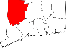 | |
| Towns | ||
| Non-consolidated city |
| |
| Boroughs | ||
| Other communities | ||