List of waterfalls in Hamilton, Ontario

The city of Hamilton in Ontario, Canada is home to more than 100 waterfalls and cascades, most of which are on or near the Bruce Trail as it winds through the Niagara Escarpment. Ontario's internationally recognized Niagara Escarpment provides perfect geological conditions for waterfalls to occur, from Tobermory to Niagara Falls.
The most scenic waterfall in Hamilton is Webster's Falls. With its 30 metres (98 ft) crest, it is the largest waterfall within the city.[1] Tew's Falls is a 41 metres (135 ft) ribbon waterfall, and is the tallest waterfall found in Hamilton. Both Webster's and Tew's are located at the Spencer Gorge / Webster's Falls Conservation Area.[1] Albion Falls was once seriously considered as a possible source of water for Hamilton. Rocks from the Albion Falls area were used in the construction of the Royal Botanical Gardens' Rock Garden.[2]
There used to be more waterfalls in Hamilton than exist today. Many of the waterfalls in central Hamilton slowly vanished as population and construction on Hamilton Mountain increased. As well, in the early years, James Street extended south, but was interrupted by a bog at Hunter Street which eventually (1844) was drained out and graded.[3] Many of Hamilton's main buildings and factories in the north end are built on reclaimed or infilled land, which harmed the drainage of Hamilton and the water ecology of Hamilton Harbour.
Many of the falls in west Hamilton are accessible from the Chedoke Radial Trail. It is built on what was once the route for the Brantford and Hamilton Electric Railway owned by the Cataract Power Light and Traction Company (later Dominion Power and Transmission).[2] The "Five Johns", (John Cameron, John Dickenson (Canadian politician), John Morison Gibson, John Moodie, Sr. and John Sutherland), formed The Cataract Power Co. Ltd. introducing electric power to Hamilton in 1898. On August 25, 1898, power was sent twenty seven miles from DeCew Falls, St. Catharines, using water from the old Welland Canal. New industries, such as the forerunners of the Steel Co. of Canada (Stelco) and Canadian Westinghouse, were attracted here by the cheaper, more efficient power. One time this Company controlled hydro power from Brantford to St. Catharines, including the Hamilton Street Railway and the area's radial lines. Back then the city's nickname was "The Electric City."[4]

There are four waterfall types and they are designated as follows:
- Ribbon- The height is notably greater than its crest width; stream forms a thin "ribbon" of water.
- Classical- The height and crest width are nearly equal.
- Curtain- The height is notably smaller than its crest width.
- Cascade- The vertical drop is broken into a series of steps causing water to "cascade" down incline.
Some of the criteria used to define a separate Hamilton waterfall include: The waterfall has to have a vertical drop of at least 3 metres or 10 feet (3.0 m) either as a vertical drop or a cascade, the crest width has to be at least 1 metre or 3 feet (0.91 m) wide, the waterfall must have some natural component and not be entirely man-made; If a waterfall is beside another waterfall but coming from two separate creeks or streams, then they could be considered as two separate waterfalls and the waterfall has to be located within the boundaries of the new City of Hamilton.[5]
On January 1, 2001 the new city of Hamilton was formed from the amalgamation of the Regional Municipality of Hamilton-Wentworth and its six municipalities: Hamilton, Ancaster, Dundas, Flamborough, Glanbrook, and Stoney Creek. Before amalgamation, the "old" City of Hamilton had 331,121 Hamiltonians divided into 100 neighbourhoods. The new amalgamated city has 490,268 people in over 200 neighbourhoods.[3]
Waterfalls list
A listing of the 100 waterfalls found along the Bruce Trail and the Niagara Escarpment in Hamilton, Ontario, Canada. Most can be easily accessed, or viewed by public lands and some are on or border private property. As of July 2008, the waterfall count for Hamilton was 100.[1] Twenty of the waterfalls are found to be currently innaccessible because they are either on private property in which the Bruce Trail does not traverse or its too dangerous to access these waterfalls.[6][7]
There are 18 waterfalls from this list, (and the expanded list below), that are either 18 metres in height or 18 metres wide. They are the ones designated in bold type.
Expanded waterfall list
There are two primary sources used for the waterfall count in Hamilton. The first is a book put out by the Hamilton Conservation Authority called "Hamilton Waterfalls and Cascades - Research & Inventory Report (Second Edition November 1, 2007)." The second source is a list compiled by the Hamilton Naturalists' Club and can be found at their web site. The book lists 96 and the web site lists 100 waterfalls. When you cross-reference the two you end up getting five extra waterfalls from the book that are not listed at the web site. This then brings the grand total of Hamilton waterfalls up to 105. These extra five waterfalls are listed below:
Note: Both Lower and Middle Quarry Cascades are based in Burlington right near the Hamilton/ Burlington city boundary line. Their watersource, Grindstone Creek and Upper Quarry Cascade are both based in Hamilton. As well, Lower and Snake Falls are based in Burlington but the property there is owned by the City of Hamilton.[6]
|
|
|
Thirty four of these 105 waterfalls lie on private property. 11 are owned by Canadian National Railway (CN) and 23 are by individual property owners. In some cases waterfalls found on private properties can still be accessed with permission from the owners. With some of the other waterfalls found on private properties they are off limits entirely.
- Private properties owned by CN are designated with: (P-CN)
- Private properties not owned by CN designated with: (P)
Images
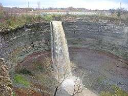 Devil's Punch Bowl
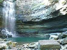 Chedoke Falls
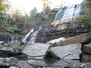 Albion Falls, King's Forest Park
See also
References
- 1 2 3 "Hamilton- Waterfall Capital of the World". (www.cityofwaterfalls.ca). Retrieved 2008-08-20.
- 1 2 "Hamilton Conservation Authority: Parks & Attractions- Albion Falls". Archived from the original on 2008-08-01. Retrieved 2008-08-20.
- 1 2 Manson, Bill (2003). Footsteps In Time: Exploring Hamilton's heritage neighbourhoods. North Shore Publishing Inc. ISBN 1-896899-22-6.
- ↑ Bailey, Thomas Melville (1991). Dictionary of Hamilton Biography (Vol II, 1876-1924). W.L. Griffin Ltd.
- ↑ "Hamilton Naturalist's Club: Protecting Nature since 1919". (www.hamiltonnature.org/). Retrieved 2008-07-19.
- 1 2 Hamilton Waterfalls and Cascades: Research & Inventory Report, 2nd Edition. Hamilton Conservation Authority. November 2007. pp. 50–51.
- ↑ "Hamilton Naturalist's Club: Hamilton- The City of Waterfalls". (www.hamiltonnature.org/). Retrieved 2008-07-28.
| Wikimedia Commons has media related to Hamilton, Ontario. |
External links
- Great Lakes waterfalls and beyond (www.gowaterfalling.com)
- Cascades and Waterfalls of Hamilton (www.waterfalls.hamilton.ca)
- Hamilton- "The Waterfall Capital of the World" (www.cityofwaterfalls.ca)
- Hamilton Conservation Authority- Waterfalls (www.conservationhamilton.ca)
- Hamilton Naturalists Club (www.hamiltonnature.org)
- Hamilton Waterfalls- Photo Gallery (www.hamilton.worldweb.com)
- Bruce Trail (www.brucetrail.org)
- Travel the Niagara Escarpment: Parks in the City of Hamilton (www.escarpment.org)
- Vintage Postcards: Waterfalls in and around Hamilton, Ontario
Maps
- Hamilton Waterfall Map PDF. (http://map.hamilton.ca)
- Map: Hamilton Waterfalls (www.hamiltonnature.org)
Video clips
| National parks |  | |
|---|---|---|
| Provincial parks | ||
| Conservation areas | ||
| UNESCO Biosphere Reserves | ||
| National Historic Sites of Canada | ||
| Other areas | ||