East Indonesia Islands from
ISS. Six active volcanoes are visible: 5 in East Java, and
Rinjani in Lombok.
The geography of Indonesia is dominated by volcanoes that are formed due to subduction zones between the Eurasian plate and the Indo-Australian plate. Some of the volcanoes are notable for their eruptions, for instance, Krakatau for its global effects in 1883,[1] Lake Toba for its supervolcanic eruption estimated to have occurred 74,000 years before present which was responsible for six years of volcanic winter,[2] and Mount Tambora for the most violent eruption in recorded history in 1815.[3]
Volcanoes in Indonesia are part of the Pacific Ring of Fire. The 150 entries in the list below are grouped into six geographical regions, four of which belong to the volcanoes of the Sunda Arc trench system. The remaining two groups are volcanoes of Halmahera, including its surrounding volcanic islands, and volcanoes of Sulawesi and the Sangihe Islands. The latter group is in one volcanic arc together with the Philippine volcanoes.
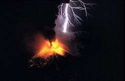
The most active volcanoes are Kelud and Merapi on Java island which have been responsible for thousands of deaths in the region. Since AD 1000, Kelut has erupted more than 30 times, of which the largest eruption was at scale 5 on the Volcanic Explosivity Index (VEI),[4] while Mount Merapi has erupted more than 80 times.[5] The International Association of Volcanology and Chemistry of the Earth's Interior has named Mount Merapi as a Decade Volcano since 1995 because of its high volcanic activity.
In 2012, Indonesia has 127 active volcanoes with about 5 million people have activities within the danger zone. The earthquake and tsunami event of 26 December 2004 is thought to bring disruption to the volcanoes' eruption pattern. The 2010 eruption of Mount Sinabung, which has no recorded eruption since the 1600s, is presented as one possible example of the hypothesis.[6]
The word for Mount in Indonesian and many regional languages of the country (such as Javanese) is Gunung. Thus, Mount Merapi for example, is referred to as Gunung Merapi in Indonesian and also in some English-based sites.
Scope
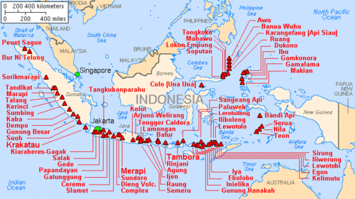
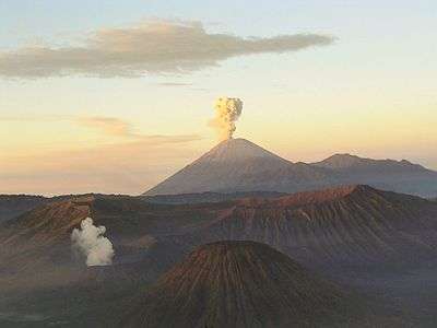
Major volcanoes in Indonesia
There is no single standard definition for a volcano. It can be defined from individual vents, volcanic edifices or volcanic fields. Interior of ancient volcanoes may have been eroded, creating a new subsurface magma chamber as a separate volcano. Many contemporary active volcanoes rise as young parasitic cones from flank vents or at a central crater. Some volcanic cones are grouped into one volcano name, for instance, the Tengger caldera complex, although individual vents are named by local people. The status of a volcano, either active or dormant, cannot be defined precisely. An indication of a volcano is determined by either its historical records, radiocarbon dating, or geothermal activities.
The primary source of the list below is taken from the Volcanoes of the World book, compiled by two volcanologists Tom Simkin and Lee Siebert,[lower-alpha 1] in which active volcanoes in the past 10,000 years (Holocene) are listed.[7] Particularly for Indonesia, Simkin and Siebert used a catalogue of active volcanoes from the International Association of Volcanology and Chemistry of the Earth's Interior publication series.[lower-alpha 2] The Simkin and Siebert list is the most complete list of volcanoes in Indonesia, but the accuracy of the record varies from one region to another in terms of contemporary activities and fatalities in recent eruptions. Complementary sources for the latest volcanic data are taken from the Volcanological Survey of Indonesia, a governmental institution which is responsible for volcanic activities and geological hazard mitigation in Indonesia,[8] and some academic resources.
Geographical groups
Sumatra
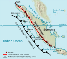
Map showing the location of volcanoes and geological fault lines of Sumatra
The geography of Sumatra is dominated by a mountain range called Bukit Barisan (lit: "a row of hills"). The mountain range spans nearly 1,700 km (1,100 mi) from the north to the south of the island, and it was formed by movement of the Australian tectonic plate.[9] The plate moves with a convergence rate of 5.5 cm/year which has created major earthquakes on the western side of Sumatra including the 2004 Sumatra–Andaman earthquake.[10][11] The tectonic movement has been responsible not only for earthquakes, but also for the formulation of magma chambers beneath the island.[9]
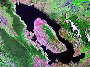
Only one of the 35 active volcanoes, Weh, is separated from the Sumatran mainland. The separation was caused by a large eruption that filled the lowland between Weh and the rest of the mainland with sea water in the Pleistocene epoch. The largest volcano of Sumatra is the supervolcano Toba within the 100 km (62 mi) × 30 km (19 mi) Lake Toba, which was created after a caldera collapse (est. in 74,000 Before Present).[2] The eruption is estimated to have been at level eight on the VEI scale, the largest possible for a volcanic eruption. The highest peak of the mountain range is Mount Kerinci with an elevation of 3,800 m (12,467 ft).
| Name | Shape | Elevation | Last eruption (VEI) | Geolocation |
| Weh | stratovolcano | 7002617000000000000♠617 metres (2,024 ft) | -999997412000-01-01-0000Pleistocene | 5°49′N 95°17′E / 5.82°N 95.28°E / 5.82; 95.28 |
| Seulawah Agam | stratovolcano | 7003181000000000000♠1,810 metres (5,940 ft) | 000000001839-01-01-00001839 (2) | 5°26′53″N 95°39′29″E / 5.448°N 95.658°E / 5.448; 95.658 |
| Peuet Sague | complex volcano | 7003280100000000000♠2,801 metres (9,190 ft) | 000000002000-12-25-000025 December 2000 (2) | 4°54′50″N 96°19′44″E / 4.914°N 96.329°E / 4.914; 96.329 |
| Geureudong | stratovolcano | 7003288500000000000♠2,885 metres (9,465 ft) | 000000001937-01-01-00001937 | 4°48′47″N 96°49′12″E / 4.813°N 96.82°E / 4.813; 96.82 |
| Kembar | shield volcano | 7003224500000000000♠2,245 metres (7,365 ft) | -999997412000-01-01-0000Pleistocene | 3°51′00″N 97°39′50″E / 3.850°N 97.664°E / 3.850; 97.664 |
| Sibayak | stratovolcano | 7003221200000000000♠2,212 metres (7,257 ft) | 000000001881-01-01-00001881 | 3°14′N 98°31′E / 3.23°N 98.52°E / 3.23; 98.52 |
| Sinabung | stratovolcano | 7003246000000000000♠2,460 metres (8,070 ft) | 000000002016-05-22-000022 May 2016 | 3°10′12″N 98°23′31″E / 3.17°N 98.392°E / 3.17; 98.392 |
| Toba | supervolcano | 7003215700000000000♠2,157 metres (7,077 ft) | 72000 BC | 2°35′N 98°50′E / 2.58°N 98.83°E / 2.58; 98.83 |
| Helatoba-Tarutung | fumarole field | 7003110000000000000♠1,100 metres (3,600 ft) | -999997412000-01-01-0000Pleistocene | 2°02′N 98°56′E / 2.03°N 98.93°E / 2.03; 98.93 |
| Imun | unknown | 7003150500000000000♠1,505 metres (4,938 ft) | unknown | 2°09′29″N 98°55′48″E / 2.158°N 98.93°E / 2.158; 98.93 |
| Sibualbuali | stratovolcano | 7003181900000000000♠1,819 metres (5,968 ft) | unknown | 1°33′22″N 99°15′18″E / 1.556°N 99.255°E / 1.556; 99.255 |
| Lubukraya | stratovolcano | 7003186200000000000♠1,862 metres (6,109 ft) | unknown | 1°28′41″N 99°12′32″E / 1.478°N 99.209°E / 1.478; 99.209 |
| Sorikmarapi | stratovolcano | 7003214500000000000♠2,145 metres (7,037 ft) | 000000001986-01-01-00001986 (1) | 0°41′10″N 99°32′20″E / 0.686°N 99.539°E / 0.686; 99.539 |
| Talakmau | complex volcano | 7003291900000000000♠2,919 metres (9,577 ft) | unknown | 0°04′44″N 99°58′48″E / 0.079°N 99.98°E / 0.079; 99.98 |
| Sarik-Gajah | volcanic cone | unknown | unknown | 0°00′29″N 100°12′00″E / 0.008°N 100.20°E / 0.008; 100.20 |
| Marapi | complex volcano | 7003289100000000000♠2,891 metres (9,485 ft) | 000000002004-08-05-00005 August 2004 (2) | 0°22′52″S 100°28′23″E / 0.381°S 100.473°E / -0.381; 100.473 |
| Tandikat | stratovolcano | 7003243800000000000♠2,438 metres (7,999 ft) | 000000001924-01-01-00001924 (1) | 0°25′59″S 100°19′01″E / 0.433°S 100.317°E / -0.433; 100.317 |
| Talang | stratovolcano | 7003259700000000000♠2,597 metres (8,520 ft) | 000000002005-04-12-000012 April 2005 (2) | 0°58′41″S 100°40′44″E / 0.978°S 100.679°E / -0.978; 100.679 |
| Kerinci | stratovolcano | 7003380000000000000♠3,800 metres (12,500 ft) | 000000002004-06-22-000022 June 2004 (2) | 1°41′49″S 101°15′50″E / 1.697°S 101.264°E / -1.697; 101.264 |
| Hutapanjang | stratovolcano | 7003202100000000000♠2,021 metres (6,631 ft) | unknown | 2°20′S 101°36′E / 2.33°S 101.60°E / -2.33; 101.60 |
| Sumbing | stratovolcano | 7003250700000000000♠2,507 metres (8,225 ft) | 000000001921-05-23-000023 May 1921 (2) | 2°24′50″S 101°43′41″E / 2.414°S 101.728°E / -2.414; 101.728 |
| Kunyit | stratovolcano | 7003215100000000000♠2,151 metres (7,057 ft) | unknown | 2°35′31″S 101°37′48″E / 2.592°S 101.63°E / -2.592; 101.63 |
| Pendan | unknown | unknown | unknown | 2°49′S 102°01′E / 2.82°S 102.02°E / -2.82; 102.02 |
| Belirang-Beriti | compound | 7003195800000000000♠1,958 metres (6,424 ft) | unknown | 2°49′S 102°11′E / 2.82°S 102.18°E / -2.82; 102.18 |
| Bukit Daun | stratovolcano | 7003246700000000000♠2,467 metres (8,094 ft) | unknown | 3°23′S 102°22′E / 3.38°S 102.37°E / -3.38; 102.37 |
| Kaba | stratovolcano | 7003195200000000000♠1,952 metres (6,404 ft) | 000000002000-08-22-000022 August 2000 (1) | 3°31′S 102°37′E / 3.52°S 102.62°E / -3.52; 102.62 |
| Dempo | stratovolcano | 7003317300000000000♠3,173 metres (10,410 ft) | 000000001994-10-01-0000October 1994 (1) | 4°02′S 103°08′E / 4.03°S 103.13°E / -4.03; 103.13 |
| Patah | unknown | 7003281700000000000♠2,817 metres (9,242 ft) | unknown | 4°16′S 103°18′E / 4.27°S 103.30°E / -4.27; 103.30 |
| Bukit Lumut Balai | stratovolcano | 7003205500000000000♠2,055 metres (6,742 ft) | unknown | 4°14′S 103°37′E / 4.23°S 103.62°E / -4.23; 103.62 |
| Besar | stratovolcano | 7003189900000000000♠1,899 metres (6,230 ft) | 000000001940-04-01-0000April 1940 (1) | 4°26′S 103°40′E / 4.43°S 103.67°E / -4.43; 103.67 |
| Ranau | caldera | 7003188100000000000♠1,881 metres (6,171 ft) | unknown | 4°50′S 103°55′E / 4.83°S 103.92°E / -4.83; 103.92 |
| Sekincau Belirang | caldera | 7003171900000000000♠1,719 metres (5,640 ft) | unknown | 5°07′S 104°19′E / 5.12°S 104.32°E / -5.12; 104.32 |
| Suoh | caldera | 7003100000000000000♠1,000 metres (3,300 ft) | 000000001933-07-10-000010 July 1933 (4) | 5°15′S 104°16′E / 5.25°S 104.27°E / -5.25; 104.27 |
| Hulubelu | caldera | 7003104000000000000♠1,040 metres (3,410 ft) | 000000001836-01-01-00001836 | 5°21′S 104°36′E / 5.35°S 104.60°E / -5.35; 104.60 |
| Rajabasa | stratovolcano | 7003128100000000000♠1,281 metres (4,203 ft) | 000000001798-01-01-00001798 | 5°46′48″S 105°37′30″E / 5.78°S 105.625°E / -5.78; 105.625 |
Sunda Strait and Java
The Sunda Strait separates the islands of Sumatra and Java with the volcanic island Krakatoa lying between them. Krakatau erupted violently in 1883, destroying two-thirds of the island and leaving a large caldera under the sea. This cataclysmic explosion was heard as far away as the island of Rodrigues near Mauritius (approx. 4,800 kilometres (3,000 mi) away).[1] A new parasitic cone, called Anak Krakatau (or the child of Krakatau), rose from the sea at the centre of the caldera in 1930.[12] The other Krakatau islets from the 1883 eruptions are known as Sertung, Panjang and Rakata.
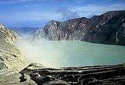
Java is a relatively small island compared to Sumatra, but it has a higher concentration of active volcanoes. There are 45 active volcanoes on the island excluding 20 small craters and cones in the Dieng volcanic complex and the young cones in the Tengger caldera complex. Some volcanoes are grouped together in the list below because of their close location. Mount Merapi, Semeru and Kelud are the most active volcanoes in Java. Mount Semeru has been continuously erupting since 1967.[13] Mount Merapi has been named as one of the Decade Volcanoes since 1995.[14] Ijen has a unique colourful caldera lake which is an extremely acidic natural reservoir (pH<0.3).[15] There are sulphur mining activities at Ijen, where miners collect highly concentrated sulphur rocks by hand.
| Name | Shape | Elevation | Last eruption (VEI) | Geolocation |
| Krakatau | caldera | 7002813000000000000♠813 metres (2,667 ft) | 000000002011-01-11-000011 January 2011 | 6°06′07″S 105°25′23″E / 6.102°S 105.423°E / -6.102; 105.423 |
| Pulosari | stratovolcano | 7003134600000000000♠1,346 metres (4,416 ft) | unknown | 6°20′31″S 105°58′30″E / 6.342°S 105.975°E / -6.342; 105.975 |
| Gunung Karang | stratovolcano | 7003177800000000000♠1,778 metres (5,833 ft) | unknown | 6°16′12″S 106°02′31″E / 6.27°S 106.042°E / -6.27; 106.042 |
| Kiaraberes-Gagak | stratovolcano | 7003151100000000000♠1,511 metres (4,957 ft) | 000000001939-04-06-00006 April 1939 (1) | 6°44′S 106°39′E / 6.73°S 106.65°E / -6.73; 106.65 |
| Perbakti | stratovolcano | 7003169900000000000♠1,699 metres (5,574 ft) | unknown | 6°45′S 106°41′E / 6.75°S 106.68°E / -6.75; 106.68 |
| Salak | stratovolcano | 7003221100000000000♠2,211 metres (7,254 ft) | 000000001938-01-31-000031 January 1938 (2) | 6°43′S 106°44′E / 6.72°S 106.73°E / -6.72; 106.73 |
| Gede | stratovolcano | 7003295800000000000♠2,958 metres (9,705 ft) | 000000001957-03-13-000013 March 1957 (2) | 6°47′S 106°59′E / 6.78°S 106.98°E / -6.78; 106.98 |
| Patuha | stratovolcano | 7003243400000000000♠2,434 metres (7,986 ft) | unknown | 7°09′36″S 107°24′00″E / 7.160°S 107.40°E / -7.160; 107.40 |
| Wayang-Windu | lava dome | 7003218200000000000♠2,182 metres (7,159 ft) | unknown | 7°12′29″S 107°37′48″E / 7.208°S 107.63°E / -7.208; 107.63 |
| Malabar | stratovolcano | 7003234300000000000♠2,343 metres (7,687 ft) | unknown | 7°08′S 107°39′E / 7.13°S 107.65°E / -7.13; 107.65 |
| Tangkuban Perahu | stratovolcano | 7003208400000000000♠2,084 metres (6,837 ft) | 000000001983-09-14-000014 September 1983 (1) | 6°46′S 107°36′E / 6.77°S 107.60°E / -6.77; 107.60 |
| Papandayan | stratovolcano | 7003266500000000000♠2,665 metres (8,743 ft) | 000000002002-11-11-000011 November 2002 (2) | 7°19′S 107°44′E / 7.32°S 107.73°E / -7.32; 107.73 |
| Kendang | stratovolcano | 7003260800000000000♠2,608 metres (8,556 ft) | unknown | 7°14′S 107°43′E / 7.23°S 107.72°E / -7.23; 107.72 |
| Kamojang | stratovolcano | 7003173000000000000♠1,730 metres (5,680 ft) | -999997412000-01-01-0000Pleistocene | 7°07′30″S 107°48′00″E / 7.125°S 107.80°E / -7.125; 107.80 |
| Guntur | complex volcano | 7003224900000000000♠2,249 metres (7,379 ft) | 000000001847-10-16-000016 October 1847 (2) | 7°08′35″S 107°50′24″E / 7.143°S 107.840°E / -7.143; 107.840 |
| Tampomas | stratovolcano | 7003168400000000000♠1,684 metres (5,525 ft) | unknown | 6°46′S 107°57′E / 6.77°S 107.95°E / -6.77; 107.95 |
| Galunggung | stratovolcano | 7003216800000000000♠2,168 metres (7,113 ft) | 000000001984-01-09-00009 January 1984 (1) | 7°15′00″S 108°03′29″E / 7.25°S 108.058°E / -7.25; 108.058 |
| Talagabodas | stratovolcano | 7003220100000000000♠2,201 metres (7,221 ft) | unknown | 7°12′29″S 108°04′12″E / 7.208°S 108.07°E / -7.208; 108.07 |
| Karaha | fumarole | 7003115500000000000♠1,155 metres (3,789 ft) | unknown | 7°07′S 108°05′E / 7.12°S 108.08°E / -7.12; 108.08 |
| Cereme | stratovolcano | 7003307800000000000♠3,078 metres (10,098 ft) | 000000001951-01-01-00001951 | 6°53′31″S 108°24′00″E / 6.892°S 108.40°E / -6.892; 108.40 |
| Slamet | stratovolcano | 7003343200000000000♠3,432 metres (11,260 ft) | 000000001999-05-01-00001 May 1999 (1) | 7°14′31″S 109°12′29″E / 7.242°S 109.208°E / -7.242; 109.208 |
| Dieng | complex volcano | 7003256500000000000♠2,565 metres (8,415 ft) | 000000001996-12-31-000031 December 1996 (1) | 7°12′S 109°55′E / 7.20°S 109.92°E / -7.20; 109.92 |
| Sundoro | stratovolcano | 7003313600000000000♠3,136 metres (10,289 ft) | 000000001971-10-29-000029 October 1971 (2) | 7°18′00″S 109°59′31″E / 7.30°S 109.992°E / -7.30; 109.992 |
| Sumbing | stratovolcano | 7003337100000000000♠3,371 metres (11,060 ft) | 000000001730-01-01-00001730 (1) | 7°23′02″S 110°04′12″E / 7.384°S 110.070°E / -7.384; 110.070 |
| Ungaran | stratovolcano | 7003205000000000000♠2,050 metres (6,730 ft) | unknown | 7°11′S 110°20′E / 7.18°S 110.33°E / -7.18; 110.33 |
| Telomoyo | stratovolcano | 7003189400000000000♠1,894 metres (6,214 ft) | unknown | 7°22′S 110°24′E / 7.37°S 110.40°E / -7.37; 110.40 |
| Merbabu | stratovolcano | 7003314500000000000♠3,145 metres (10,318 ft) | 000000001797-01-01-00001797 (2) | 7°27′S 110°26′E / 7.45°S 110.43°E / -7.45; 110.43 |
| Merapi | stratovolcano | 7003296800000000000♠2,968 metres (9,738 ft) |
000000002010-10-26-000026 October 2010 (4)[16] |
7°32′31″S 110°26′31″E / 7.542°S 110.442°E / -7.542; 110.442 |
| Muria | stratovolcano | 7003162500000000000♠1,625 metres (5,331 ft) | -999999999840-01-01-0000160 BC ± 30 years | 6°37′S 110°53′E / 6.62°S 110.88°E / -6.62; 110.88 |
| Lawu | stratovolcano | 7003326500000000000♠3,265 metres (10,712 ft) | 000000001885-11-28-000028 November 1885 (1) | 7°37′30″S 111°11′31″E / 7.625°S 111.192°E / -7.625; 111.192 |
| Wilis | stratovolcano | 7003256300000000000♠2,563 metres (8,409 ft) | unknown | 7°48′29″S 111°45′29″E / 7.808°S 111.758°E / -7.808; 111.758 |
| Kelud | stratovolcano | 7003173100000000000♠1,731 metres (5,679 ft) | 000000002014-02-13-000013 February 2014 (4) | 7°55′48″S 112°18′29″E / 7.93°S 112.308°E / -7.93; 112.308 |
| Kawi-Butak | stratovolcano | 7003265100000000000♠2,651 metres (8,698 ft) | unknown | 7°55′S 112°27′E / 7.92°S 112.45°E / -7.92; 112.45 |
| Arjuno-Welirang | stratovolcano | 7003333900000000000♠3,339 metres (10,955 ft) | 000000001952-08-15-000015 August 1952 (0) | 7°43′30″S 112°34′48″E / 7.725°S 112.58°E / -7.725; 112.58 |
| Penanggungan | stratovolcano | 7003165300000000000♠1,653 metres (5,423 ft) | unknown | 7°37′S 112°38′E / 7.62°S 112.63°E / -7.62; 112.63 |
| Malang Plain | maar | 7002680000000000000♠680 metres (2,230 ft) | unknown | 8°01′S 112°41′E / 8.02°S 112.68°E / -8.02; 112.68 |
| Semeru | stratovolcano | 7003367600000000000♠3,676 metres (12,060 ft) | 000000001967-01-01-00001967–2006 continuing (3) | 8°06′29″S 112°55′12″E / 8.108°S 112.92°E / -8.108; 112.92 |
| Tengger | stratovolcano | 7003232900000000000♠2,329 metres (7,641 ft) | 000000002004-06-08-00008 June 2004 (2) | 7°56′31″S 112°57′00″E / 7.942°S 112.95°E / -7.942; 112.95 |
| Lamongan | stratovolcano | 7003165100000000000♠1,651 metres (5,417 ft) | 000000001898-02-05-00005 February 1898 (2) | 7°58′44″S 113°20′31″E / 7.979°S 113.342°E / -7.979; 113.342 |
| Lurus | complex volcano | 7002539000000000000♠539 metres (1,768 ft) | unknown | 7°44′S 113°35′E / 7.73°S 113.58°E / -7.73; 113.58 |
| Iyang-Argapura | complex volcano | 7003308800000000000♠3,088 metres (10,131 ft) | unknown | 7°58′S 113°34′E / 7.97°S 113.57°E / -7.97; 113.57 |
| Raung | stratovolcano | 7003333200000000000♠3,332 metres (10,932 ft) | 000000002015-06-29-000029 June 2015 (?) | 8°07′30″S 114°02′31″E / 8.125°S 114.042°E / -8.125; 114.042 |
| Ijen | stratovolcano | 7003279900000000000♠2,799 metres (9,183 ft) | 000000001999-06-28-000028 June 1999 (1) | 8°03′29″S 114°14′31″E / 8.058°S 114.242°E / -8.058; 114.242 |
| Baluran | stratovolcano | 7003124700000000000♠1,247 metres (4,091 ft) | unknown | 7°51′S 114°22′E / 7.85°S 114.37°E / -7.85; 114.37 |
Note: Height of Krakatau is of Rakata, not of the active Anak Krakatau
Lesser Sunda Islands
The Lesser Sunda Islands is a small archipelago which, from west to east, consists of Bali, Lombok, Sumbawa, Flores, Sumba and the Timor islands; all are located at the edge of the Australian continental shelf. Volcanoes in the area are formed because of oceanic crusts and the movement of the shelf itself.[17] Some volcanoes completely form an island, for instance, the Sangeang Api island. Mount Tambora, on Sumbawa island, erupted on 5 April 1815, with a scale 7 on the VEI and is considered the most violent eruption in recorded history.[3]
| Name | Shape | Elevation | Last eruption (VEI) | Geolocation |
| Merbuk | tba | 7003138600000000000♠1,386 metres (4,547 ft) | unknown | - |
| Bratan | caldera | 7003227600000000000♠2,276 metres (7,467 ft) | unknown | 8°17′S 115°08′E / 8.28°S 115.13°E / -8.28; 115.13 |
| Batur | caldera | 7003171700000000000♠1,717 metres (5,633 ft) | 000000001999-03-15-000015 March 1999 (1) | 8°14′31″S 115°22′30″E / 8.242°S 115.375°E / -8.242; 115.375 |
| Agung | stratovolcano | 7003314200000000000♠3,142 metres (10,308 ft) | 000000001963-02-18-000018 February 1963 (5) | 8°20′31″S 115°30′29″E / 8.342°S 115.508°E / -8.342; 115.508 |
| Rinjani | stratovolcano | 7003372600000000000♠3,726 metres (12,224 ft) | 000000002004-10-01-00001 October 2004 (2) | 8°25′S 116°28′E / 8.42°S 116.47°E / -8.42; 116.47 |
| Tambora | stratovolcano | 7003272200000000000♠2,722 metres (8,930 ft) | 000000001967-01-01-00001967 ± 20 years (0) | 8°15′S 118°00′E / 8.25°S 118.00°E / -8.25; 118.00 |
| Sangeang Api | complex volcano | 7003194900000000000♠1,949 metres (6,394 ft) | 000000002014-05-30-000030 May 2014 (?) | 8°12′S 119°04′E / 8.20°S 119.07°E / -8.20; 119.07 |
| Wai Sano | caldera | 7002903000000000000♠903 metres (2,963 ft) | unknown | 8°43′S 120°01′E / 8.72°S 120.02°E / -8.72; 120.02 |
| Poco Leok | unknown | 7003167500000000000♠1,675 metres (5,495 ft) | unknown | 8°41′S 120°29′E / 8.68°S 120.48°E / -8.68; 120.48 |
| Ranakah | lava dome | 7003210000000000000♠2,100 metres (6,900 ft) | 000000001991-03-01-0000March 1991 (1) | 8°37′S 120°31′E / 8.62°S 120.52°E / -8.62; 120.52 |
| Inierie | stratovolcano | 7003224500000000000♠2,245 metres (7,365 ft) | -999999991950-01-01-00008050 BC | 8°52′30″S 120°57′00″E / 8.875°S 120.95°E / -8.875; 120.95 |
| Inielika | complex volcano | 7003155900000000000♠1,559 metres (5,115 ft) | 000000002001-01-11-000011 January 2001 (2) | 8°44′S 120°59′E / 8.73°S 120.98°E / -8.73; 120.98 |
| Ebulobo | stratovolcano | 7003212400000000000♠2,124 metres (6,969 ft) | 000000001969-02-27-000027 February 1969 (2) | 8°49′S 121°11′E / 8.82°S 121.18°E / -8.82; 121.18 |
| Iya | stratovolcano | 7002637000000000000♠637 metres (2,090 ft) | 000000001969-01-27-000027 January 1969 (3) | 8°53′49″S 121°38′42″E / 8.897°S 121.645°E / -8.897; 121.645 |
| Sukaria | caldera | 7003150000000000000♠1,500 metres (4,900 ft) | unknown | 8°47′31″S 121°46′12″E / 8.792°S 121.77°E / -8.792; 121.77 |
| Ndete Napu | fumarole | 7002750000000000000♠750 metres (2,460 ft) | unknown | 8°43′S 121°47′E / 8.72°S 121.78°E / -8.72; 121.78 |
| Kelimutu | complex volcano | 7003163900000000000♠1,639 metres (5,377 ft) | 000000001968-06-03-00003 June 1968 (1) | 8°46′S 121°49′E / 8.77°S 121.82°E / -8.77; 121.82 |
| Paluweh | stratovolcano | 7002875000000000000♠875 metres (2,871 ft) | 000000001985-02-03-00003 February 1985 (1) | 8°19′12″S 121°42′29″E / 8.32°S 121.708°E / -8.32; 121.708 |
| Egon | stratovolcano | 7003170300000000000♠1,703 metres (5,587 ft) | 000000002005-02-06-00006 February 2005 (1) | 8°40′S 122°27′E / 8.67°S 122.45°E / -8.67; 122.45 |
| Ilimuda | stratovolcano | 7003110000000000000♠1,100 metres (3,600 ft) | unknown | 8°28′41″S 122°40′16″E / 8.478°S 122.671°E / -8.478; 122.671 |
| Lewotobi | stratovolcano | 7003170300000000000♠1,703 metres (5,587 ft) | 000000002003-05-30-000030 May 2003 (2) | 8°32′31″S 122°46′30″E / 8.542°S 122.775°E / -8.542; 122.775 |
| Leroboleng | complex volcano | 7003111700000000000♠1,117 metres (3,665 ft) | 000000002003-06-26-000026 June 2003 (3) | 8°21′29″S 122°50′31″E / 8.358°S 122.842°E / -8.358; 122.842 |
| Riang Kotang | fumarole | 7002200000000000000♠200 metres (660 ft) | unknown | 8°18′00″S 122°53′31″E / 8.30°S 122.892°E / -8.30; 122.892 |
| Iliboleng | stratovolcano | 7003165900000000000♠1,659 metres (5,443 ft) | 000000001993-06-01-0000June 1993 (1) | 8°20′31″S 123°15′29″E / 8.342°S 123.258°E / -8.342; 123.258 |
| Lewotolo | stratovolcano | 7003142300000000000♠1,423 metres (4,669 ft) | 000000001951-12-15-000015 December 1951 (2) | 8°16′19″S 123°30′18″E / 8.272°S 123.505°E / -8.272; 123.505 |
| Ililabalekan | stratovolcano | 7003101800000000000♠1,018 metres (3,340 ft) | unknown | 8°33′S 123°23′E / 8.55°S 123.38°E / -8.55; 123.38 |
| Iliwerung | complex volcano | 7003101800000000000♠1,018 metres (3,340 ft) | 000000001999-05-22-000022 May 1999 (0) | 8°32′S 123°34′E / 8.53°S 123.57°E / -8.53; 123.57 |
| Batu Tara | stratovolcano | 7002748000000000000♠748 metres (2,454 ft) | 000000001847-01-01-00001847 (2) | 7°47′31″S 123°34′44″E / 7.792°S 123.579°E / -7.792; 123.579 |
| Sirung | complex volcano | 7002862000000000000♠862 metres (2,828 ft) | 000000001970-01-01-00001970 (2) | 8°30′29″S 124°07′48″E / 8.508°S 124.13°E / -8.508; 124.13 |
| Yersey | submarine | 2996620000000000000♠−3,800 metres (−12,500 ft) | unknown | 7°32′S 123°57′E / 7.53°S 123.95°E / -7.53; 123.95 |
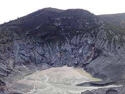
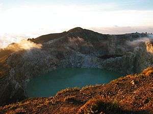
| One of three different coloured lakes of Kelimutu |
|
Banda Sea
The Banda Sea in the south of the Molucca archipelago includes a small group of islands. Three major tectonic plates beneath the sea, Eurasian, Pacific and Indo-Australian plates, have been converging since the Mesozoic epoch.[18] Volcanoes in the Banda Sea are mainly islands, but some are submarine volcanoes.
Sulawesi and Sangihe Islands
Four peninsulas dominate the shape of Sulawesi island (formerly known as Celebes). The central part is a high mountainous area, but mostly non-volcanic. Active volcanoes are found in the northern peninsula and continuously stretch to the north to Sangihe Islands. The Sangihe Islands mark the border with the Philippines.
| Name | Shape | Elevation | Last eruption (VEI) | Geolocation |
| Colo | stratovolcano | 7002507000000000000♠507 metres (1,663 ft) | 000000001983-07-18-000018 July 1983 (4) | 0°10′12″S 121°36′29″E / 0.17°S 121.608°E / -0.17; 121.608 |
| Ambang | complex volcano | 7003179500000000000♠1,795 metres (5,889 ft) | 000000001845-01-01-00001845 ± 5 years | 0°45′N 124°25′E / 0.75°N 124.42°E / 0.75; 124.42 |
| Soputan | stratovolcano | 7003178400000000000♠1,784 metres (5,853 ft) | 000000002007-10-24-000024–30 October 2007 | 1°06′29″N 124°43′48″E / 1.108°N 124.73°E / 1.108; 124.73 |
| Sempu | caldera | 7003154900000000000♠1,549 metres (5,082 ft) | unknown | 1°07′48″N 124°45′29″E / 1.13°N 124.758°E / 1.13; 124.758 |
| Tondano | caldera | 7003120200000000000♠1,202 metres (3,944 ft) | unknown | 1°14′N 124°50′E / 1.23°N 124.83°E / 1.23; 124.83 |
| Lokon-Empung | stratovolcano | 7003158000000000000♠1,580 metres (5,180 ft) | 000000002011-07-15-000015 July 2011 | 1°21′29″N 124°47′31″E / 1.358°N 124.792°E / 1.358; 124.792 |
| Mahawu | stratovolcano | 7003132400000000000♠1,324 metres (4,344 ft) | 000000001977-11-16-000016 November 1977 (0) | 1°21′29″N 124°51′29″E / 1.358°N 124.858°E / 1.358; 124.858 |
| Klabat | stratovolcano | 7003199500000000000♠1,995 metres (6,545 ft) | unknown | 1°28′N 125°02′E / 1.47°N 125.03°E / 1.47; 125.03 |
| Tongkoko | stratovolcano | 7003114900000000000♠1,149 metres (3,770 ft) | 000000001880-01-01-00001880 (1) | 1°31′N 125°12′E / 1.52°N 125.20°E / 1.52; 125.20 |
| Ruang | stratovolcano | 7002725000000000000♠725 metres (2,379 ft) | 000000002002-09-25-000025 September 2002 (4) | 2°18′N 125°22′E / 2.30°N 125.37°E / 2.30; 125.37 |
| Karangetang | stratovolcano | 7003178400000000000♠1,784 metres (5,853 ft) | 000000002007-08-01-0000August 2007 | 2°47′N 125°24′E / 2.78°N 125.40°E / 2.78; 125.40 |
| Banua Wuhu | submarine | 2999500000000000000♠−5 metres (−16 ft) | 000000001919-07-18-000018 July 1919 (3) | 3°08′17″N 125°29′28″E / 3.138°N 125.491°E / 3.138; 125.491 |
| Awu | stratovolcano | 7003132000000000000♠1,320 metres (4,330 ft) | 000000002004-06-02-00002 June 2004 (2) | 3°40′N 125°30′E / 3.67°N 125.50°E / 3.67; 125.50 |
| Submarine 1922 | submarine | 2996500000000000000♠−5,000 metres (−16,000 ft) | unknown | 3°58′N 125°10′E / 3.97°N 125.17°E / 3.97; 125.17 |

Vuurberg (Dutch: fire mountain, Gunung Api) in
BandanairaHalmahera
Halmahera island in the north of Molucca archipelago has been formed by the movement of three tectonic plates resulting in two intersecting mountain ranges, which form four rocky peninsulas separated by three deep bays. A volcanic arc stretches from north to south in the west side of Halmahera, some of which are volcanic islands, for instance, Gamalama and Tidore. Gamalama's island name is Ternate and it has been the centre for spice trading since the Portuguese Empire opened a fort in 1512. Due to its location as the centre for spice trading during the Age of Discovery, historical records of volcanic eruptions in Halmahera have been available as far back as the early 16th century.
| Name | Shape | Elevation | Last eruption (VEI) | Geolocation |
| Tarakan | pyroclastic cone | 7002318000000000000♠318 metres (1,043 ft) | unknown | 1°50′N 127°50′E / 1.83°N 127.83°E / 1.83; 127.83 |
| Dukono | complex volcano | 7003133500000000000♠1,335 metres (4,380 ft) | 000000001933-08-13-000013 August 1933 (3) | 1°41′N 127°53′E / 1.68°N 127.88°E / 1.68; 127.88 |
| Tobaru | unknown | 7003103500000000000♠1,035 metres (3,396 ft) | unknown | 1°38′N 127°40′E / 1.63°N 127.67°E / 1.63; 127.67 |
| Ibu | stratovolcano | 7003132500000000000♠1,325 metres (4,347 ft) | 000000002005-05-01-0000May 2005 (0) | 1°29′17″N 127°37′48″E / 1.488°N 127.63°E / 1.488; 127.63 |
| Gamkonora | stratovolcano | 7003163500000000000♠1,635 metres (5,364 ft) | 000000002007-07-09-00009 July 2007 (?) | 1°23′N 127°32′E / 1.38°N 127.53°E / 1.38; 127.53 |
| Todoko-Ranu | caldera | 7002979000000000000♠979 metres (3,212 ft) | unknown | 1°15′N 127°28′E / 1.25°N 127.47°E / 1.25; 127.47 |
| Jailolo | stratovolcano | 7003113000000000000♠1,130 metres (3,710 ft) | unknown | 1°05′N 127°25′E / 1.08°N 127.42°E / 1.08; 127.42 |
| Hiri | stratovolcano | 7002630000000000000♠630 metres (2,070 ft) | unknown | 0°54′N 127°19′E / 0.90°N 127.32°E / 0.90; 127.32 |
| Gamalama | stratovolcano | 7003171500000000000♠1,715 metres (5,627 ft) | 000000002003-07-31-000031 July 2003 (2) | 0°48′N 127°20′E / 0.80°N 127.33°E / 0.80; 127.33 |
| Tidore | stratovolcano | 7003173000000000000♠1,730 metres (5,680 ft) | unknown | 0°39′29″N 127°24′00″E / 0.658°N 127.40°E / 0.658; 127.40 |
| Mare | stratovolcano | 7002308000000000000♠308 metres (1,010 ft) | unknown | 0°34′N 127°24′E / 0.57°N 127.40°E / 0.57; 127.40 |
| Moti | stratovolcano | 7002950000000000000♠950 metres (3,120 ft) | unknown | 0°27′N 127°24′E / 0.45°N 127.40°E / 0.45; 127.40 |
| Makian | stratovolcano | 7003135700000000000♠1,357 metres (4,452 ft) | 000000001988-07-29-000029 July 1988 (3) | 0°19′N 127°24′E / 0.32°N 127.40°E / 0.32; 127.40 |
| Tigalalu | stratovolcano | 7002422000000000000♠422 metres (1,385 ft) | unknown | 0°04′N 127°25′E / 0.07°N 127.42°E / 0.07; 127.42 |
| Amasing | stratovolcano | 7003103000000000000♠1,030 metres (3,380 ft) | unknown | 0°32′S 127°29′E / 0.53°S 127.48°E / -0.53; 127.48 |
| Bibinoi | stratovolcano | 7002900000000000000♠900 metres (3,000 ft) | unknown | 0°46′S 127°43′E / 0.77°S 127.72°E / -0.77; 127.72 |
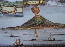
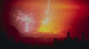
Depiction of
Gamalama erupting in the early 1700s with a Portuguese fort shown
Major eruptions
Below is a list of selected major eruptions of volcanoes in Indonesia, sorted chronologically by the starting date of the eruption. Only eruptions with scale 3 or above on VEI are given with known sources and fatalities, except if smaller scale eruptions resulted some fatalities.
| Eruption date | Volcano | Cessation date | VEI | Characteristics | Tsunami | Tephra volume | Fatality | Sources |
| 000000002010-11-03-00003 November 2010 | Merapi | 000000002010-11-08-00008 November 2010 | 4 | cv,pf,ld,lm | no | N/A | 138 |
[5] |
| 000000001990-02-10-000010 February 1990 | Kelut | 000000001990-03-01-0000March 1990 | 4 | cv,cl,pf,ph,ld,lm | no | 0.13 km³ | 35 |
[19] |
| 000000001983-07-18-000018 July 1983 | Colo | 000000001983-12-01-0000December 1983 | 4 | cv,pf,ph | no | N/A | 0 |
[19] |
| 000000001982-04-05-00005 April 1982 | Galunggung | 000000001983-01-08-00008 January 1983 | 4 | cv,pf,lf,lm | no | 0.37 km³ + | 68 |
[20][21] |
| 000000001972-10-06-00006 October 1972 | Merapi | 000000001985-03-01-0000March 1985 | 2 | cv,pf,lf,ld,lm | no | 0.021 km³ | 29 |
[5] |
| 000000001966-04-26-000026 April 1966 | Kelut | 000000001966-04-27-000027 April 1966 | 4 | cv,cl,pf,lm | no | 0.089 km³ | 212 |
[19] |
| 000000001963-03-17-000017 March 1963 | Agung | 000000001964-01-27-000027 January 1964 | 5 | cv,pf,lf,lm | no | 1 km³ | 1,148 |
[22] |
| 000000001951-08-31-000031 August 1951 | Kelut | 000000001951-08-31-000031 August 1951 | 4 | cv,cl,pf,lm | no | 0.2 km³ | 7 |
[19] |
| 000000001930-11-25-000025 November 1930 | Merapi | 000000001931-09-01-0000September 1931 | 3 | cv,rf,pf,lf,ld,lm | no | 0.0017 km³ | 1,369 |
[5] |
| 000000001919-05-19-000019 May 1919 | Kelut | 000000001919-05-20-000020 May 1919 | 4 | cv,cl,pf,lm | no | 0.19 km³ | 5,110 |
[19] |
| 000000001892-06-07-00007 June 1892 | Awu | 000000001892-06-12-000012 June 1892 | 3 | cv,pf,lm | yes | N/A | 1,532 |
[23] |
| 000000001883-08-26-000026 August 1883 | Krakatau | 000000001884-02-01-0000February 1884 | 6 | cv,se,pf,fa,lm,cc | 15–42 m | 5–8.5 km³ | 36,600 |
[1][22][24] |
| 000000001872-04-15-000015 April 1872 | Merapi | 000000001872-04-21-000021 April 1872 | 4 | cv,pf | no | 0.33 km³ | 200 |
[5] |
| 000000001856-03-02-00002 March 1856 | Awu | 000000001856-03-17-000017 March 1856 | 3 | cv,pf,lm | yes | 0.51±0.50 km³ | 2,806 |
[23] |
| 000000001822-10-08-00008 October 1822 | Galunggung | 000000001822-12-01-0000December 1822 | 5 | cv,pf,ld,lm | no | 1 km³ + | 4,011 |
[19] |
| 000000001815-04-10-000010 April 1815 | Mount Tambora | 000000001815-07-15-000015 July 1815 | 7 | cv,pf,cc | 1–2 m | 160 km³ | 71,000+ |
[3][25] |
| 000000001812-08-06-00006 August 1812 | Awu | 000000001812-08-08-00008 August 1812 | 4 | cv,pf,lm | no | 0.55±0.50 km³ | 963 |
[23] |
| 000000001772-08-12-000012 August 1772 | Papandayan | 000000001772-08-12-000012 August 1772 | 3 | cv,ph | no | N/A | 2,957 |
[26] |
| 000000001672-08-04-00004 August 1672 | Merapi | 000000001672-01-01-0000unknown | 3 | cv,pf,lm | no | N/A | 3,000 |
[5] |
| 000000001586-01-01-00001586 | Kelut | 000000001586-01-01-0000unknown | 5 | cf,cl,lm | no | 1 km³ + | 10,000 |
[19] |
| -999999926000-01-01-0000≈ 74,000 BP | Toba | -999999926000-01-01-0000unknown | 8 | pf,lf,cc | likely | 2,800 km³ | near extinction all of the human population |
[2] |
Notes: cv=central vent eruption, pf=
pyroclastic flows, lf=
lava flows, lm=
lahar mudflows, cl=
crater lake eruption, ph=
phreatic eruption, ld=
lava dome extrusion, cc=
caldera collapse, se=
submarine eruption, fa=
fumarole activity, rf=radial fissure eruption.
See also
References
General references
- ↑ Tom Simkin & Lee Siebert (1994). Volcanoes of the World: A Regional Directory, Gazetteer, and Chronology of Volcanism During the Last 10,000 Years (2nd ed.). Geoscience Press. ISBN 0-945005-12-1.
- ↑ M. Neumann van Padang (1951). "Indonesia". Catalog of Active Volcanoes of the World and Solfatara Fields (1 ed.). Rome: IAVCEI. pp. 1–271.
Notes
- 1 2 3 Winchester, Simon (2003). Krakatoa: The Day the World Exploded: August 27, 1883. HarperCollins. ISBN 0-06-621285-5.
- 1 2 3 Oppenheimer, C. (2002). "Limited global change due to the largest known Quaternary eruption, Toba ≈74 kyr BP?". Quaternary Science Reviews. 21 (14–15): 1593–1609. Bibcode:2002QSRv...21.1593O. doi:10.1016/S0277-3791(01)00154-8.
- 1 2 3 Stothers, Richard B. (1984). "The Great Tambora Eruption in 1815 and Its Aftermath". Science. 224 (4654): 1191–1198. Bibcode:1984Sci...224.1191S. doi:10.1126/science.224.4654.1191. PMID 17819476.
- ↑ "Kelut Eruptive History". Global Volcanism Program. Smithsonian Institution. Retrieved 19 December 2006.
- 1 2 3 4 5 6 "Merapi Eruptive History". Global Volcanism Program. Smithsonian Institution. Retrieved 19 December 2006.
- ↑ "Indonesia Miliki 127 Gunung Api Aktif". 2 May 2012.
- ↑ "Volcano Data Criteria". Global Volcanism Program. Smithsonian Institution. Retrieved 14 June 2015.
- ↑ "Centre of Volcanology & Geological Hazard Mitigation". Volcanological Survey of Indonesia. Archived from the original on 16 December 2006. Retrieved 31 December 2006.
- 1 2 Simoes, M., Avouac, J.P., Cattin, R., Henry, P. (2004). "The Sumatra subduction zone: A case for a locked fault zone extending into the mantle" (PDF). Journal of Geophysical Research. 109: B10402. Bibcode:2004JGRB..10910402S. doi:10.1029/2003JB002958.
- ↑ Subarya, C., Chlieh, M., Prawirodirdjo, L., Avouac, J.P., Bock, Y., Sieh, K., Meltzner, A., Natawidjaja, D.H., McCaffrey, R. (2006). "Plate-boundary deformation associated with the great Sumatra-Andaman earthquake" (PDF). Nature. 440 (7080): 46–51. Bibcode:2006Natur.440...46S. doi:10.1038/nature04522. PMID 16511486.
- ↑ Lay, T., Kanamori, H., Ammon, C., Nettles, M., Ward, S., Aster, R., Beck, S., Bilek, S., Brudzinski, M., Butler, R., DeShon, H., Ekstrom, G. (2005). "The Great Sumatra-Andaman Earthquake of 26 December 2004" (PDF). Science. 308 (5725): 1127–1133. Bibcode:2005Sci...308.1127L. doi:10.1126/science.1112250. PMID 15905392.
- ↑ Whittaker, R. J.; Bush, M. B. (1993). "Anak Krakatau and old Krakatau: a reply". GeoJournal. 29 (4): 417–420. doi:10.1007/BF00807545.
- ↑ "Semeru Weekly Reports". Global Volcanism Program. Smithsonian Institution. Retrieved 7 December 2006.
- ↑ International Association of Volcanology and Chemistry of the Earth's Interior (1995). "Decade Volcano Update". Bulletin of Volcanology. 57 (1): 82–83. Bibcode:1995BVol...57...76.. doi:10.1007/BF00298711.
- ↑ Ansje Löhr; Thom Bogaard; Alex Heikens; Martin Hendriks; Sri Sumarti; Manfred van Bergen; Kees C.A.M. van Gestel; Nico van Straalen; Pieter Vroonand & Budi Widianarko (2005). "Natural Pollution Caused by the Extremely Acid Crater Lake Kawah Ijen, East Java, Indonesia". Environmental Science and Pollution Research. 12 (2): 89–95. doi:10.1065/espr2004.09.118.
- ↑ "Mount Merapi Erupts". ANTARA. 26 October 2010. Retrieved 19 November 2013.
- ↑ H. A. Brouwer (July 1939). "Exploration in the Lesser Sunda Islands". The Geographical Journal. Blackwell Publishing. 94 (1): 1–10. doi:10.2307/1788584. JSTOR 1788584.
- ↑ Christian Honthaasa, Jean-Pierre Réhaulta, René C. Maurya, Hervé Bellona, Christophe Hémonda, Jacques-André Maloda, Jean-Jacques Cornéeb, Michel Villeneuveb, Joseph Cottena, Safri Burhanuddinc, Hervé Guilloud and Nicolas Arnaud (1998). "A Neogene back-arc origin for the Banda Sea basins: geochemical and geochronological constraints from the Banda ridges (East Indonesia)". Tectonophysics. 298 (4): 297–317. Bibcode:1998Tectp.298..297H. doi:10.1016/S0040-1951(98)00190-5.
- 1 2 3 4 5 6 7 "Large Holocene Eruptions". Global Volcanism Program. Smithsonian Institution. Retrieved 18 December 2006.
- ↑ Katili, J.A. & Sudradjat, A. (1984). "Galunggung: the 1982-1983 eruption". Volcanology Survei Indonesia: 102.
- ↑ "Galunggung, Java, Indonesia". Volcano World. Department of Geosciences at Oregon State University. Archived from the original on 16 June 2008. Retrieved 30 December 2006.
- 1 2 Michael R. Rampino & Stephen Self (1982). "Historic eruptions of Tambora (1815), Krakatau (1883), and Agung (1963), their stratospheric aerosols, and climatic impact". Quaternary Research. 18 (2): 127–143. Bibcode:1982QuRes..18..127R. doi:10.1016/0033-5894(82)90065-5.
- 1 2 3 "Awu's Eruptive History". Global Volcanism Program. Smithsonian Institution. Retrieved 31 December 2006.
- ↑ B.H. Choi, E. Pelinovsky, K.O. Kim and J.S. Lee (2003). "Simulation of the trans-oceanic tsunami propagation due to the 1883 Krakatau volcanic eruption" (PDF). Natural Hazards and Earth System Sciences. 3 (5): 321–332. doi:10.5194/nhess-3-321-2003.
- ↑ Oppenheimer, Clive (2003). "Climatic, environmental and human consequences of the largest known historic eruption: Tambora volcano (Indonesia) 1815". Progress in Physical Geography. 27 (2): 230–259. doi:10.1191/0309133303pp379ra.
- ↑ "The Deadliest Eruptions". Volcano World. Department of Geosciences at Oregon State University. Retrieved 15 March 2009.
External links
|
|---|
|
| History | | |
|---|
|
| Geography | |
|---|
|
| Politics | |
|---|
|
| Economy | |
|---|
|
| Culture | |
|---|
|
|