List of underground stations of the Merseyrail network
This article lists the six underground stations and five below ground level stations of the Merseyrail network which is centred on Liverpool, England.
Underground stations
| Coordinates | Station | Area | Photo | Platforms | Opened | Usage 2010/11 (million)[1] | Managed by | Line(s) | Zone |
|---|---|---|---|---|---|---|---|---|---|
| 53°24′16″N 2°58′47″W / 53.4045°N 2.9797°W | Liverpool Central | Liverpool City Centre | 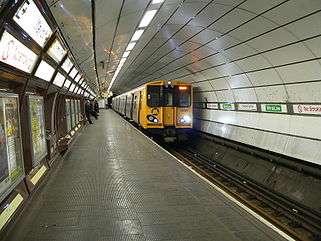 | 3 | 1892 (Low level) | 17.958 | Merseyrail | Northern Wirral | C1 |
| 53°23′35″N 3°01′23″W / 53.393°N 3.023°W | Conway Park | Birkenhead | 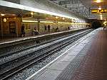 | 2 | 22 June 1998.[2] | 1.724 | Merseyrail | Wirral | B1 |
| 53°23′41″N 3°00′50″W / 53.3947°N 3.0139°W | Birkenhead Hamilton Square | Birkenhead | 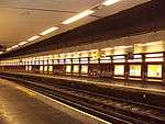 | 3 | 1 February 1886.[3] | 2.507 | Merseyrail | Wirral | B1 |
| 53°24′17″N 2°59′31″W / 53.4048°N 2.9919°W | James Street | Liverpool City Centre | 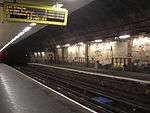 | 3 | 1886 | 3.320 | Merseyrail | Wirral | C1 |
| 53°24′27″N 2°58′42″W / 53.4075°N 2.9784°W | Liverpool Lime Street | Liverpool City Centre | 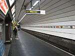 | 1[note 1] | 1836 | 11.812[note 2] | Merseyrail (Underground only) | Wirral | C1 |
| 53°24′31″N 2°59′21″W / 53.4086°N 2.9892°W | Moorfields | Liverpool City Centre | 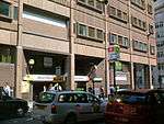 | 3 | 2 May 1977 (Northern Line)[4] 30 October 1977 (Wirral Line)[4] | 4.637 | Merseyrail | Northern Wirral | C1 |
Sub-surface stations - built in cuttings
| Coordinates | Station | Area | Photo | Platforms | Opened | Usage 2010/11 (million)[1] | Managed by | Line(s) | Zones |
|---|---|---|---|---|---|---|---|---|---|
| 53°23′20″N 3°01′08″W / 53.389°N 3.019°W | Birkenhead Central | Birkenhead Town Centre | 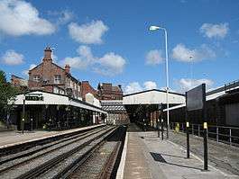 | 2 | 1886 | 0.996 | Merseyrail | Wirral | B1 |
| 53°22′59″N 3°00′58″W / 53.383°N 3.016°W | Green Lane | Tranmere | 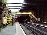 | 2 | 1886 | 0.693 | Merseyrail | Wirral | B1 |
| 53°26′15″N 2°59′15″W / 53.4376°N 2.9875°W | Bank Hall | Kirkdale | .jpg) | 2 | 1850 | 0.172 | Merseyrail | Northern | B1 |
| 53°23′00″N 2°58′34″W / 53.3833°N 2.9762°W | Brunswick | Toxteth | .jpg) | 2 | 1998 (station on present site) | 0.963 | Merseyrail | Northern | B1 |
| 53°22′33″N 2°57′10″W / 53.3757°N 2.9529°W | Aughton Park | Aughton | .jpg) | 2 | 1907 | 0.096 | Merseyrail | Northern | B1 |
Former stations
| Coordinates | Station | Area | Image | Platforms | Opened | Closed | Managed by |
|---|---|---|---|---|---|---|---|
| 53°23′39″N 2°58′35″W / 53.3943°N 2.9764°W | St James | Toxteth | - | 2 | 1 March 1874[5][6] | 1 January 1917[5][6] | Cheshire Lines Committee |
St James railway station will be reopened as part of the Liverpool City Region transport plan.[7]
Future
Merseyrail plan to make a fully underground 'Circle Line' to serve Liverpool's inner city districts surrounding the city centre. The line will use the 5 miles of disused tunnels underneath Liverpool, including the Dingle Tunnel and the Waterloo Tunnel and a new Cut and Cover Tunnel near the riverside can also be easily built.[8]
St James railway station, which has been closed for a century, may reopen because of the important Baltic Triangle development in Toxteth. If opened, the station will be on the Merseyrail Northern Line between Liverpool Central and Brunswick railway station
Notes
References
- 1 2 "Office of Rail Regulation - Station Usage". Retrieved 17 March 2013.
- ↑ "Conway Park station opens plus 'Smart' bus service". Wirral Globe. 1998-06-24. Retrieved 2008-01-11.
- ↑ Butt, R.V.J. (1995). The Directory of Railway Stations. Yeovil: Patrick Stephens Ltd. p. 112. ISBN 1-85260-508-1. R508.
- 1 2 Butt, R.V.J. (1995). The Directory of Railway Stations. Yeovil: Patrick Stephens Ltd. p. 162. ISBN 1-85260-508-1. R508.
- 1 2 Butt (1995), p. 203.
- 1 2 Quick (2009), p. 249.
- ↑ http://www.merseytravel.gov.uk/about-us/media-centre/news/Pages/Liverpool-City-Region%E2%80%99s-30-year-rail-future-detailed-in-new-strategy.aspx
- ↑ http://myweb.tiscali.co.uk/watercity/Merseyrail-Extensions.html
Sources
- Butt, R. V. J. (1995). The Directory of Railway Stations: details every public and private passenger station, halt, platform and stopping place, past and present (1st ed.). Sparkford: Patrick Stephens Ltd. ISBN 1-8526-0508-1. OCLC 60251199.
- Quick, Michael (2009) [2001]. Railway passenger stations in Great Britain: a chronology (4th ed.). Oxford: Railway and Canal Historical Society. ISBN 978-0-901461-57-5. OCLC 612226077.