List of protected heritage sites in Genappe
This table shows an overview of the protected heritage sites in the Walloon town Genepiën, or Genappe. This list is part of Belgium's national heritage.
| Object |
Year/architect |
Town/section |
Address |
Coordinates |
Number? |
Image |
|---|---|---|---|---|---|---|
| The mountains of Thy (nl) (fr) |
Genepien | Baisy-Thy en Ways | 50°36′33″N 4°27′53″E / 50.609127°N 4.464603°E |
25031-CLT-0002-01 Info |
||
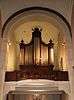
| Organs of the church of Saint-Pierre (nl) (fr) |
Genepien | 50°37′48″N 4°27′13″E / 50.629881°N 4.453529°E |
25031-CLT-0004-01 Info |
|||
| Organs of the church of Saint-Jean Baptiste (nl) (fr) |
Genepien | 50°35′51″N 4°26′33″E / 50.597447°N 4.442387°E |
25031-CLT-0007-01 Info |
|||
| Chapel of Notre-Dame de Foy Loupoigne including the surrounding grounds (nl) (fr) |
Genepien | 50°36′06″N 4°27′08″E / 50.601761°N 4.452271°E |
25031-CLT-0008-01 Info |
|||
| Caillou farm, even the house located at the front of the Brussels road, and the enclosing wall and ensemble of the said farm, garden and outbuildings (nl) (fr) |
Genepien | 50°38′46″N 4°25′15″E / 50.646046°N 4.420703°E |
25031-CLT-0009-01 Info |
 | ||
| Church of Saint Martin (nl) (fr) |
Genepien | 50°36′36″N 4°27′45″E / 50.610044°N 4.462492°E |
25031-CLT-0011-01 Info |
 | ||
| Facade and roof of house (nl) (fr) |
Genepien | rue du centre n° 32 | 50°35′54″N 4°26′35″E / 50.598338°N 4.442981°E |
25031-CLT-0012-01 Info |
 | |
| Farm: facades and roofs (nl) (fr) |
Genepien | place Charles Morimont n° 1 | 50°35′52″N 4°26′30″E / 50.597883°N 4.441758°E |
25031-CLT-0014-01 Info |
 | |
| Organs in the church of Saint-Hubert (nl) (fr) |
Genepien | 50°35′38″N 4°27′57″E / 50.593804°N 4.465860°E |
25031-CLT-0016-01 Info |
 | ||
| Tower and two wings forming the body of the church of Saint Jean Baptiste (nl) (fr) |
Genepien | 50°35′51″N 4°26′32″E / 50.597426°N 4.442294°E |
25031-CLT-0017-01 Info |
|||
| Farm "Basse Cour" of the castle: facades and roofs (nl) (fr) |
Genepien | rue du Centre n° 37 | 50°35′50″N 4°26′30″E / 50.597323°N 4.441669°E |
25031-CLT-0018-01 Info |
||
| Ensemble of the old mill, church and the farms (nl) (fr) |
Genepien | 50°35′49″N 4°26′20″E / 50.597074°N 4.438926°E |
25031-CLT-0019-01 Info |
|||
| Monument "aux Belges" of 1815, the route Houtain <sup style="text-align:right; line-height:1em;
margin-left:0.3em; color:blue; cursor:help; font-family:Verdana,sans-serif;"
title="Monument "aux Belges" van 1815, route de Houtain">(nl) (fr) |
Genepien | 50°34′23″N 4°26′54″E / 50.573050°N 4.448246°E |
25031-CLT-0020-01 Info |
|||
| Ensemble of the forest of Conins and the wooded parts of the ponds (nl) (fr) |
Genepien | 50°38′55″N 4°30′40″E / 50.648745°N 4.511000°E |
25031-CLT-0021-01 Info |
|||
| Facades, roofs and stained glass of the chapel of Chantelet (nl) (fr) |
Genepien | 50°39′00″N 4°26′03″E / 50.649902°N 4.434034°E |
25031-CLT-0023-01 Info |
|||
| Chapel of Try-au-Chêne and the shrines of Our Lady of Alsemberg and ensemble of these monuments and their surroundings (nl) (fr) |
Genepien | 50°36′29″N 4°30′51″E / 50.608099°N 4.514121°E |
25031-CLT-0024-01 Info |
 | ||
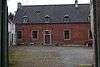
| Façade and roof of the building, setting up a protection zone (nl) (fr) |
Genepien | rue de Ways 39 | 50°36′39″N 4°27′09″E / 50.610697°N 4.452388°E |
25031-CLT-0025-01 Info |
_du_CPAS_de_Genappe.JPG) | |
| Farm of Caillou: establishment of a protection zone (nl) (fr) |
Genepien | 50°38′55″N 4°25′25″E / 50.648495°N 4.423473°E |
25031-CLT-0027-01 Info |
See also
| Wikimedia Commons has media related to Cultural heritage monuments in Genappe. |
References
- Belgian heritage register: Direction générale opérationnelle - Aménagement du territoire, Logement, Patrimoine et Energie (DG4)
- www.dglive.be
This article is issued from Wikipedia - version of the 5/21/2016. The text is available under the Creative Commons Attribution/Share Alike but additional terms may apply for the media files.