List of protected heritage sites in Braine-l'Alleud
This table shows an overview of the protected heritage sites in the Walloon town Eigenbrakel, or Braine-l'Alleud. This list is part of Belgium's national heritage.
| Object |
Year/architect |
Town/section |
Address |
Coordinates |
Number? |
Image |
|---|---|---|---|---|---|---|
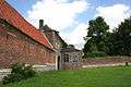
| Farm of Hougoumont (nl) (fr) |
Eigenbrakel | 50°40′15″N 4°23′40″E / 50.670749°N 4.394492°E |
25014-CLT-0001-01 Info |
 | ||
| Chapel of Ermite (nl) (fr) |
Eigenbrakel | 50°43′02″N 4°20′57″E / 50.717338°N 4.349209°E |
25014-CLT-0002-01 Info |
|||
| Ensemble of the chapel of "Moûtier de l'Ermite" and its environment (nl) (fr) |
Eigenbrakel | 50°43′04″N 4°20′51″E / 50.717720°N 4.347432°E |
25014-CLT-0003-01 Info |
|||
| Site of the ponds of the seven fountains and surrounding areas located in the center of Braine (nl) (fr) |
Eigenbrakel | 50°43′02″N 4°19′11″E / 50.717269°N 4.319822°E |
25014-CLT-0004-01 Info |
|||
| Lion of Waterloo (nl) (fr) |
Eigenbrakel | 50°40′44″N 4°24′18″E / 50.678848°N 4.404872°E |
25014-CLT-0006-01 Info |
.JPG) | ||
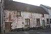
| Building (nl) (fr) |
Eigenbrakel | rue des Jambes n° 37 | 50°40′59″N 4°22′03″E / 50.682928°N 4.367531°E |
25014-CLT-0008-01 Info |
 | |
| Empire Building at the corner of the place Abbe Renard and rue des Trois Apôtres (nl) (fr) |
Eigenbrakel | place Abbé Renard 7 en rue des Trois Apôtres 1, 3, 5 en 7 | 50°40′58″N 4°22′14″E / 50.682755°N 4.370651°E |
25014-CLT-0009-01 Info |
 | |
| Facades and roofs of the old town hall (nl) (fr) |
Eigenbrakel | Grand'Place 12-13, Braine-L'Alleud | 50°40′56″N 4°22′10″E / 50.682236°N 4.369522°E |
25014-CLT-0013-01 Info |
.JPG) | |
| Site of castle, abbey park, chapel of Saint-Sang, the farm and entrance building of the abbey Bois Seigneur-Isaac (nl) (fr) |
Eigenbrakel | 50°38′42″N 4°19′02″E / 50.644952°N 4.317174°E |
25014-CLT-0014-01 Info |
 | ||
| Chapel of Saint-Sang, the facade and roof of the castle Ophain-Bois-Seigneur-Isaac and the site classified by February 2, 1944 (nl) (fr) |
Eigenbrakel | 50°38′38″N 4°19′21″E / 50.643843°N 4.322451°E |
25014-CLT-0015-01 Info |
.JPG) | ||
| Monastery chapel and the expansion of the ensemble of the castle and its surroundings (nl) (fr) |
Eigenbrakel | 50°38′46″N 4°19′02″E / 50.646043°N 4.317195°E |
25014-CLT-0016-01 Info |
|||
| The three facades that are not yet assigned in the castle of Bois-Seigneur-Isaac (nl) (fr) |
Eigenbrakel | 50°38′35″N 4°19′24″E / 50.643144°N 4.323389°E |
25014-CLT-0017-01 Info |
 | ||
| St. Martin's Church (nl) (fr) |
Eigenbrakel | 50°38′19″N 4°21′21″E / 50.638513°N 4.355827°E |
25014-CLT-0020-01 Info |
 | ||
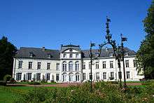
| Water Castle (nl) (fr) |
Eigenbrakel | avenue Alphonse Allard, te Saint-Sébastien | 50°40′43″N 4°22′50″E / 50.678536°N 4.380593°E |
25014-CLT-0021-01 Info |
 | |
| Water Castle (nl) (fr) |
Eigenbrakel | chaussée d'Alsemberg, te Ermite | 50°42′40″N 4°21′12″E / 50.710996°N 4.353326°E |
25014-CLT-0022-01 Info |
 | |
| Church of Saint-Etienne (nl) (fr) |
Eigenbrakel | 50°40′57″N 4°22′15″E / 50.682496°N 4.370816°E |
25014-CLT-0023-01 Info |
 | ||
| Facades and roofs of all buildings of the farm "Tout Lui Faut", and the ensemble of the farm and surrounding area <sup style="text-align:right; line-height:1em;
margin-left:0.3em; color:blue; cursor:help; font-family:Verdana,sans-serif;"
title="Gevels en daken van alle gebouwen van de boerderij "Tout lui Faut", en het ensemble van de boerderij en de omliggende terreinen">(nl) (fr) |
Eigenbrakel | 50°42′25″N 4°20′32″E / 50.707043°N 4.342171°E |
25014-CLT-0025-01 Info |
|||
| Organs of the church of Sainte Aldegonde (nl) (fr) |
Eigenbrakel | 50°39′58″N 4°20′55″E / 50.666103°N 4.348577°E |
25014-CLT-0026-01 Info |
|||
| Certain parts of the building at the foot of the Lion of Waterloo called "Panorama de la Bataille de Waterloo" <sup style="text-align:right; line-height:1em;
margin-left:0.3em; color:blue; cursor:help; font-family:Verdana,sans-serif;"
title="Bepaalde delen van het gebouw aan de voet van de Leeuw van Waterloo genaamd "Panorama de la Bataille de Waterloo"">(nl) (fr) |
Eigenbrakel | 50°40′46″N 4°24′17″E / 50.679320°N 4.404818°E |
25014-CLT-0027-01 Info |
|||
| Part of the old abby of Nizelles (nl) (fr) |
Eigenbrakel | 50°39′59″N 4°18′51″E / 50.666333°N 4.314271°E |
25014-CLT-0029-01 Info |
|||
| Camp of the Battle of Waterloo (nl) (fr) |
Eigenbrakel | 50°40′05″N 4°23′22″E / 50.668009°N 4.389375°E |
25014-CLT-0030-01 Info |
 | ||
| Memorial to the English who died there at the memorial of Gordon (nl) (fr) |
Eigenbrakel | 50°40′47″N 4°24′43″E / 50.679671°N 4.411933°E |
25014-CLT-0031-01 Info |
 | ||
| The non-visible parts in the decree of 24 February 1998 regarding the building at the foot of the Lion of Waterloo, called "Panorama de la Bataille de Waterloo" <sup style="text-align:right; line-height:1em;
margin-left:0.3em; color:blue; cursor:help; font-family:Verdana,sans-serif;"
title="De niet-zichtbare delen in het decreet van 24 februari 1998 dat wil zeggen de ontwikkelingsfase en de proscenium van het gebouw aan de voet van de Leeuw van Waterloo genaamd "Panorama de la Bataille de Waterloo"">(nl) (fr) |
Eigenbrakel | 50°40′46″N 4°24′19″E / 50.679310°N 4.405256°E |
25014-CLT-0034-01 Info |
|||
| Interior of the chapel of Saint-Sang and facades, roofs and tower of castle Ophain-Bois-Seigneur-Isaac (nl) (fr) |
Eigenbrakel | 50°38′38″N 4°19′21″E / 50.643843°N 4.322451°E |
25014-PEX-0001-01 Info |
|||
| Building called "Panorama de la Bataille de Waterloo" <sup style="text-align:right; line-height:1em;
margin-left:0.3em; color:blue; cursor:help; font-family:Verdana,sans-serif;"
title="Gebouw genaamd "Panorama de la Bataille de Waterloo"">(nl) (fr) |
Eigenbrakel | 50°40′46″N 4°24′17″E / 50.679320°N 4.404818°E |
25014-PEX-0002-01 Info |
 | ||
| Building called "Panorama de la Bataille de Waterloo" <sup style="text-align:right; line-height:1em;
margin-left:0.3em; color:blue; cursor:help; font-family:Verdana,sans-serif;"
title="Gebouw genaamd "Panorama de la Bataille de Waterloo"">(nl) (fr) |
Eigenbrakel | 50°40′46″N 4°24′19″E / 50.679310°N 4.405256°E |
25014-PEX-0003-01 Info |
|||
| The camp of the Battle of Waterloo (nl) (fr) |
Eigenbrakel | 50°40′05″N 4°23′22″E / 50.668009°N 4.389375°E |
25014-PEX-0004-01 Info |
See also
| Wikimedia Commons has media related to Cultural heritage monuments in Braine-l'Alleud. |
References
- Belgian heritage register: Direction générale opérationnelle - Aménagement du territoire, Logement, Patrimoine et Energie (DG4)
- www.dglive.be