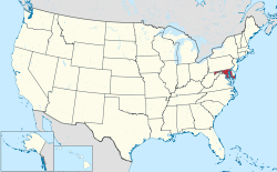
List of municipalities in Maryland
Maryland is a state located in the Southern United States. According to the 2010 United States Census, Maryland is the 19th most populous state with 5,773,785 inhabitants but the 9th smallest by land area spanning 9,707.24 square miles (25,141.6 km2) of land.[1] Maryland is divided into 23 counties and contains 157 incorporated municipalities consisting of cities, towns, or villages.[2] Incorporated municipalities cover only 4.4% of the state's land mass but are home to 26.2% of its population.[1]
Incorporated places in Maryland are self-governing municipalities chartered as cities, towns, or villages by an Act of the Maryland General Assembly or, in some cases, by a referendum.[lower-alpha 1] Municipalities are the lowest tier administrative units in Maryland, and all except Baltimore are also subject to county administration. Despite the designations of city, town, or village, there are no differences in municipal power and authority.[4] There is no official classification of municipal governments and the municipalities are equal under Maryland law.[4] The municipalities themselves decide whether to avail themselves of the specific powers conferred on them by the Maryland Constitution and state code.[4] Since its separation from Baltimore County in 1851, the City of Baltimore functions more as a county than a city under state law since it exercises charter home rule, which empowers the city with broad legislative authority similar to Maryland's six home rule counties.[5]
The largest municipality by population in Maryland is Baltimore, an independent city, with 620,961 residents, and the smallest municipality by population is Port Tobacco Village with 13 residents.[1] The largest municipality by land area is also Baltimore which spans 80.94 sq mi (209.6 km2), while Brookview is the smallest at 0.04 sq mi (0.10 km2).[1] Many of Maryland's largest population centers (such as Columbia, Germantown, Silver Spring, Waldorf, Glen Burnie, and Ellicott City) are unincorporated census designated places.[1]
Incorporated municipalities
- Largest municipalities in Maryland by population
-
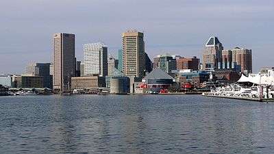
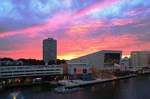
Skyline of Baltimore, the largest municipality in Maryland
-
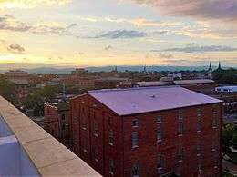
Frederick, the second largest municipality in Maryland
-
Skyline of Rockville, a suburb of Washington, D.C.
-
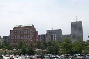
Gaithersburg, a suburb of Washington D.C.
-
Downtown Bowie, the fifth largest municipality in Maryland
-
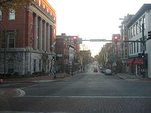
Downtown Hagerstown, Maryland's sixth largest municipality
-
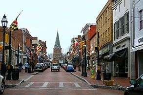
Downtown Annapolis, capital and seventh largest city of Maryland
| Name | Type[1] | County(ies)[1] | Population (2010)[1] |
Population (2000)[1] |
Change | Land area (2010)[1] |
Population density | |
|---|---|---|---|---|---|---|---|---|
| sq mi | km2 | |||||||
| Aberdeen | City | Harford | 14,959 | 13,842 | +8.1% | 6.80 | 17.6 | 2,199.9/sq mi (849.4/km2) |
| Accident | Town | Garrett | 325 | 353 | −7.9% | 0.49 | 1.3 | 663.3/sq mi (256.1/km2) |
| Annapolis |
City | Anne Arundel | 38,394 | 35,838 | +7.1% | 7.18 | 18.6 | 5,347.4/sq mi (2,064.6/km2) |
| Baltimore | City | — | 620,961 | 651,154 | −4.6% | 80.94 | 209.6 | 7,671.9/sq mi (2,962.1/km2) |
| Barclay | Town | Queen Anne's | 120 | 143 | −16.1% | 0.16 | 0.41 | 750.0/sq mi (289.6/km2) |
| Barnesville | Town | Montgomery | 172 | 161 | +6.8% | 0.49 | 1.3 | 351.0/sq mi (135.5/km2) |
| Barton | Town | Allegany | 457 | 478 | −4.4% | 0.22 | 0.57 | 2,077.3/sq mi (802.0/km2) |
| Bel Air | Town | Harford | 10,120 | 10,080 | +0.4% | 2.93 | 7.6 | 3,453.9/sq mi (1,333.6/km2) |
| Berlin | Town | Worcester | 4,485 | 3,491 | +28.5% | 3.15 | 8.2 | 1,423.8/sq mi (549.7/km2) |
| Berwyn Heights | Town | Prince George's | 3,123 | 2,942 | +6.2% | 0.69 | 1.8 | 4,526.1/sq mi (1,747.5/km2) |
| Betterton | Town | Kent | 345 | 376 | −8.2% | 0.99 | 2.6 | 348.5/sq mi (134.6/km2) |
| Bladensburg | Town | Prince George's | 9,148 | 7,661 | +19.4% | 1.00 | 2.6 | 9,148.0/sq mi (3,532.1/km2) |
| Boonsboro | Town | Washington | 3,336 | 2,803 | +19.0% | 2.90 | 7.5 | 1,150.3/sq mi (444.2/km2) |
| Bowie | City | Prince George's | 54,727 | 50,269 | +8.9% | 18.43 | 47.7 | 2,969.5/sq mi (1,146.5/km2) |
| Brentwood | Town | Prince George's | 3,046 | 2,844 | +7.1% | 0.38 | 0.98 | 8,015.8/sq mi (3,094.9/km2) |
| Brookeville | Town | Montgomery | 134 | 120 | +11.7% | 0.12 | 0.31 | 1,116.7/sq mi (431.1/km2) |
| Brookview | Town | Dorchester | 60 | 65 | −7.7% | 0.04 | 0.10 | 1,500.0/sq mi (579.2/km2) |
| Brunswick | City | Frederick | 5,870 | 4,894 | +19.9% | 3.26 | 8.4 | 1,800.6/sq mi (695.2/km2) |
| Burkittsville | Town | Frederick | 151 | 171 | −11.7% | 0.45 | 1.2 | 335.6/sq mi (129.6/km2) |
| Cambridge | City | Dorchester | 12,326 | 10,911 | +13.0% | 10.34 | 26.8 | 1,192.1/sq mi (460.3/km2) |
| Capitol Heights | Town | Prince George's | 4,337 | 4,138 | +4.8% | 0.80 | 2.1 | 5,421.3/sq mi (2,093.2/km2) |
| Cecilton | Town | Cecil | 663 | 474 | +39.9% | 0.46 | 1.2 | 1,441.3/sq mi (556.5/km2) |
| Centreville | Town | Queen Anne's | 4,285 | 1,970 | +117.5% | 2.45 | 6.3 | 1,749.0/sq mi (675.3/km2) |
| Charlestown | Town | Cecil | 1,183 | 1,019 | +16.1% | 1.19 | 3.1 | 994.1/sq mi (383.8/km2) |
| Chesapeake Beach | Town | Calvert | 5,753 | 3,180 | +80.9% | 2.71 | 7.0 | 2,122.9/sq mi (819.6/km2) |
| Chesapeake City | Town | Cecil | 673 | 787 | −14.5% | 0.50 | 1.3 | 1,346.0/sq mi (519.7/km2) |
| Chestertown | Town | Kent | 5,252 | 4,746 | +10.7% | 2.60 | 6.7 | 2,020.0/sq mi (779.9/km2) |
| Cheverly | Town | Prince George's | 6,173 | 6,433 | −4.0% | 1.35 | 3.5 | 4,572.6/sq mi (1,765.5/km2) |
| Chevy Chase | Town | Montgomery | 2,824 | 2,726 | +3.6% | 0.47 | 1.2 | 6,008.5/sq mi (2,319.9/km2) |
| Chevy Chase Section Five | Village | Montgomery | 658 | 641 | +2.7% | 0.10 | 0.26 | 6,580.0/sq mi (2,540.6/km2) |
| Chevy Chase Section Three | Village | Montgomery | 760 | 773 | −1.7% | 0.12 | 0.31 | 6,333.3/sq mi (2,445.3/km2) |
| Chevy Chase View | Town | Montgomery | 920 | 863 | +6.6% | 0.28 | 0.73 | 3,285.7/sq mi (1,268.6/km2) |
| Chevy Chase Village | Town | Montgomery | 1,953 | 2,043 | −4.4% | 0.42 | 1.1 | 4,650.0/sq mi (1,795.4/km2) |
| Church Creek | Town | Dorchester | 125 | 85 | +47.1% | 0.34 | 0.88 | 367.6/sq mi (141.9/km2) |
| Church Hill | Town | Queen Anne's | 745 | 530 | +40.6% | 0.71 | 1.8 | 1,049.3/sq mi (405.1/km2) |
| Clear Spring | Town | Washington | 358 | 455 | −21.3% | 0.11 | 0.28 | 3,254.5/sq mi (1,256.6/km2) |
| College Park | City | Prince George's | 30,413 | 24,657 | +23.3% | 5.64 | 14.6 | 5,392.4/sq mi (2,082.0/km2) |
| Colmar Manor | Town | Prince George's | 1,404 | 1,257 | +11.7% | 0.47 | 1.2 | 2,987.2/sq mi (1,153.4/km2) |
| Cottage City | Town | Prince George's | 1,305 | 1,136 | +14.9% | 0.25 | 0.65 | 5,220.0/sq mi (2,015.5/km2) |
| Crisfield | City | Somerset | 2,726 | 2,723 | +0.1% | 1.62 | 4.2 | 1,682.7/sq mi (649.7/km2) |
| Cumberland | City | Allegany | 20,859 | 21,518 | −3.1% | 10.08 | 26.1 | 2,069.3/sq mi (799.0/km2) |
| Deer Park | Town | Garrett | 399 | 405 | −1.5% | 1.00 | 2.6 | 399.0/sq mi (154.1/km2) |
| Delmar | Town | Wicomico | 3,003 | 1,859 | +61.5% | 1.72 | 4.5 | 1,745.9/sq mi (674.1/km2) |
| Denton | Town | Caroline | 4,418 | 2,960 | +49.3% | 5.28 | 13.7 | 836.7/sq mi (323.1/km2) |
| District Heights | City | Prince George's | 5,837 | 5,958 | −2.0% | 0.93 | 2.4 | 6,276.3/sq mi (2,423.3/km2) |
| Eagle Harbor | Town | Prince George's | 63 | 55 | +14.5% | 0.12 | 0.31 | 525.0/sq mi (202.7/km2) |
| East New Market | Town | Dorchester | 400 | 167 | +139.5% | 0.40 | 1.0 | 1,000.0/sq mi (386.1/km2) |
| Easton | Town | Talbot | 15,945 | 11,708 | +36.2% | 10.56 | 27.4 | 1,509.9/sq mi (583.0/km2) |
| Edmonston | Town | Prince George's | 1,445 | 959 | +50.7% | 0.39 | 1.0 | 3,705.1/sq mi (1,430.6/km2) |
| Eldorado | Town | Dorchester | 59 | 60 | −1.7% | 0.08 | 0.21 | 737.5/sq mi (284.8/km2) |
| Elkton | Town | Cecil | 15,443 | 11,893 | +29.8% | 8.35 | 21.6 | 1,849.5/sq mi (714.1/km2) |
| Emmitsburg | Town | Frederick | 2,814 | 2,290 | +22.9% | 1.52 | 3.9 | 1,851.3/sq mi (714.8/km2) |
| Fairmount Heights | Town | Prince George's | 1,494 | 1,508 | −0.9% | 0.27 | 0.70 | 5,533.3/sq mi (2,136.4/km2) |
| Federalsburg | Town | Caroline | 2,739 | 2,620 | +4.5% | 1.93 | 5.0 | 1,419.2/sq mi (547.9/km2) |
| Forest Heights | Town | Prince George's | 2,447 | 2,585 | −5.3% | 0.48 | 1.2 | 5,097.9/sq mi (1,968.3/km2) |
| Frederick | City | Frederick | 65,239 | 52,767 | +23.6% | 21.99 | 57.0 | 2,966.8/sq mi (1,145.5/km2) |
| Friendsville | Town | Garrett | 491 | 539 | −8.9% | 0.91 | 2.4 | 539.6/sq mi (208.3/km2) |
| Frostburg | City | Allegany | 9,002 | 7,873 | +14.3% | 3.42 | 8.9 | 2,632.2/sq mi (1,016.3/km2) |
| Fruitland | City | Wicomico | 4,866 | 3,774 | +28.9% | 3.78 | 9.8 | 1,287.3/sq mi (497.0/km2) |
| Funkstown | Town | Washington | 904 | 983 | −8.0% | 0.36 | 0.93 | 2,511.1/sq mi (969.5/km2) |
| Gaithersburg | City | Montgomery | 59,933 | 52,613 | +13.9% | 10.20 | 26.4 | 5,875.8/sq mi (2,268.7/km2) |
| Galena | Town | Kent | 612 | 428 | +43.0% | 0.36 | 0.93 | 1,700.0/sq mi (656.4/km2) |
| Galestown | Town | Dorchester | 138 | 101 | +36.6% | 0.23 | 0.60 | 600.0/sq mi (231.7/km2) |
| Garrett Park | Town | Montgomery | 992 | 917 | +8.2% | 0.26 | 0.67 | 3,815.4/sq mi (1,473.1/km2) |
| Glenarden | City | Prince George's | 6,000 | 6,318 | −5.0% | 1.22 | 3.2 | 4,918.0/sq mi (1,898.9/km2) |
| Glen Echo | Town | Montgomery | 255 | 242 | +5.4% | 0.10 | 0.26 | 2,550.0/sq mi (984.6/km2) |
| Goldsboro | Town | Caroline | 246 | 216 | +13.9% | 0.74 | 1.9 | 332.4/sq mi (128.4/km2) |
| Grantsville | Town | Garrett | 766 | 619 | +23.7% | 0.98 | 2.5 | 781.6/sq mi (301.8/km2) |
| Greenbelt | City | Prince George's | 23,068 | 21,456 | +7.5% | 6.28 | 16.3 | 3,673.2/sq mi (1,418.2/km2) |
| Greensboro | Town | Caroline | 1,931 | 1,632 | +18.3% | 1.05 | 2.7 | 1,839.0/sq mi (710.1/km2) |
| Hagerstown | Town | Washington | 39,662 | 36,687 | +8.1% | 11.79 | 30.5 | 3,364.0/sq mi (1,298.9/km2) |
| Hampstead | Town | Carroll | 6,323 | 5,060 | +25.0% | 3.19 | 8.3 | 1,982.1/sq mi (765.3/km2) |
| Hancock | Town | Washington | 1,545 | 1,725 | −10.4% | 2.73 | 7.1 | 565.9/sq mi (218.5/km2) |
| Havre de Grace | City | Harford | 12,952 | 11,331 | +14.3% | 5.50 | 14.2 | 2,354.9/sq mi (909.2/km2) |
| Hebron | Town | Wicomico | 1,084 | 807 | +34.3% | 1.28 | 3.3 | 846.9/sq mi (327.0/km2) |
| Henderson | Town | Caroline | 146 | 118 | +23.7% | 0.13 | 0.34 | 1,123.1/sq mi (433.6/km2) |
| Highland Beach | Town | Anne Arundel | 96 | 109 | −11.9% | 0.06 | 0.16 | 1,600.0/sq mi (617.8/km2) |
| Hillsboro | Town | Caroline | 161 | 163 | −1.2% | 0.15 | 0.39 | 1,073.3/sq mi (414.4/km2) |
| Hurlock | Town | Dorchester | 2,092 | 1,874 | +11.6% | 2.66 | 6.9 | 786.5/sq mi (303.7/km2) |
| Hyattsville | City | Prince George's | 17,557 | 14,733 | +19.2% | 2.67 | 6.9 | 6,575.7/sq mi (2,538.9/km2) |
| Indian Head | Town | Charles | 3,844 | 3,422 | +12.3% | 1.23 | 3.2 | 3,125.2/sq mi (1,206.6/km2) |
| Keedysville | Town | Washington | 1,152 | 482 | +139.0% | 0.92 | 2.4 | 1,252.2/sq mi (483.5/km2) |
| Kensington | Town | Montgomery | 2,213 | 1,873 | +18.2% | 0.48 | 1.2 | 4,610.4/sq mi (1,780.1/km2) |
| Kitzmiller | Town | Garrett | 321 | 302 | +6.3% | 0.22 | 0.57 | 1,459.1/sq mi (563.4/km2) |
| Landover Hills | Town | Prince George's | 1,687 | 1,534 | +10.0% | 0.30 | 0.78 | 5,623.3/sq mi (2,171.2/km2) |
| La Plata | Town | Charles | 8,753 | 6,551 | +33.6% | 7.40 | 19.2 | 1,182.8/sq mi (456.7/km2) |
| Laurel | City | Prince George's | 25,115 | 19,960 | +25.8% | 4.30 | 11.1 | 5,840.7/sq mi (2,255.1/km2) |
| Laytonsville | Town | Montgomery | 353 | 277 | +27.4% | 1.04 | 2.7 | 339.4/sq mi (131.1/km2) |
| Leonardtown | Town | St. Mary's | 2,930 | 1,896 | +54.5% | 3.18 | 8.2 | 921.4/sq mi (355.7/km2) |
| Loch Lynn Heights | Town | Garrett | 552 | 469 | +17.7% | 0.32 | 0.83 | 1,725.0/sq mi (666.0/km2) |
| Lonaconing | Town | Allegany | 1,214 | 1,205 | +0.7% | 0.41 | 1.1 | 2,961.0/sq mi (1,143.2/km2) |
| Luke | Town | Allegany | 65 | 80 | −18.7% | 0.27 | 0.70 | 240.7/sq mi (93.0/km2) |
| Manchester | Town | Carroll | 4,808 | 3,329 | +44.4% | 2.34 | 6.1 | 2,054.7/sq mi (793.3/km2) |
| Mardela Springs | Town | Wicomico | 347 | 364 | −4.7% | 0.39 | 1.0 | 889.7/sq mi (343.5/km2) |
| Martin's Additions | Village | Montgomery | 933 | 875 | +6.6% | 0.14 | 0.36 | 6,664.3/sq mi (2,573.1/km2) |
| Marydel | Town | Caroline | 141 | 147 | −4.1% | 0.08 | 0.21 | 1,762.5/sq mi (680.5/km2) |
| Middletown | Town | Frederick | 4,136 | 2,668 | +55.0% | 1.74 | 4.5 | 2,377.0/sq mi (917.8/km2) |
| Midland | Town | Allegany | 446 | 473 | −5.7% | 0.19 | 0.49 | 2,347.4/sq mi (906.3/km2) |
| Millington | Town | Kent, Queen Anne's | 642 | 416 | +54.3% | 0.66 | 1.7 | 972.7/sq mi (375.6/km2) |
| Morningside | Town | Prince George's | 2,015 | 1,295 | +55.6% | 0.56 | 1.5 | 3,598.2/sq mi (1,389.3/km2) |
| Mountain Lake Park | Town | Garrett | 2,092 | 2,248 | −6.9% | 1.94 | 5.0 | 1,078.4/sq mi (416.4/km2) |
| Mount Airy | Town | Carroll, Frederick | 9,288 | 6,425 | +44.6% | 4.12 | 10.7 | 2,254.4/sq mi (870.4/km2) |
| Mount Rainier | City | Prince George's | 8,080 | 8,498 | −4.9% | 0.65 | 1.7 | 12,430.8/sq mi (4,799.5/km2) |
| Myersville | Town | Frederick | 1,626 | 1,382 | +17.7% | 1.02 | 2.6 | 1,594.1/sq mi (615.5/km2) |
| New Carrollton | City | Prince George's | 12,135 | 12,589 | −3.6% | 1.53 | 4.0 | 7,931.4/sq mi (3,062.3/km2) |
| New Market | Town | Frederick | 656 | 427 | +53.6% | 0.80 | 2.1 | 820.0/sq mi (316.6/km2) |
| New Windsor | Town | Carroll | 1,396 | 1,303 | +7.1% | 0.74 | 1.9 | 1,886.5/sq mi (728.4/km2) |
| North Beach | Town | Calvert | 1,978 | 1,880 | +5.2% | 0.33 | 0.85 | 5,993.9/sq mi (2,314.3/km2) |
| North Brentwood | Town | Prince George's | 517 | 469 | +10.2% | 0.10 | 0.26 | 5,170.0/sq mi (1,996.1/km2) |
| North Chevy Chase | Village | Montgomery | 519 | 465 | +11.6% | 0.11 | 0.28 | 4,718.2/sq mi (1,821.7/km2) |
| North East | Town | Cecil | 3,572 | 2,733 | +30.7% | 2.06 | 5.3 | 1,734.0/sq mi (669.5/km2) |
| Oakland | Town | Garrett | 1,925 | 1,930 | −0.3% | 2.59 | 6.7 | 743.2/sq mi (287.0/km2) |
| Ocean City | Town | Worcester | 7,102 | 7,173 | −1.0% | 4.41 | 11.4 | 1,610.4/sq mi (621.8/km2) |
| Oxford | Town | Talbot | 651 | 771 | −15.6% | 0.54 | 1.4 | 1,205.6/sq mi (465.5/km2) |
| Perryville | Town | Cecil | 4,361 | 3,672 | +18.8% | 3.05 | 7.9 | 1,429.8/sq mi (552.1/km2) |
| Pittsville | Town | Wicomico | 1,417 | 1,182 | +19.9% | 1.68 | 4.4 | 843.5/sq mi (325.7/km2) |
| Pocomoke City | City | Worcester | 4,184 | 4,098 | +2.1% | 3.69 | 9.6 | 1,133.9/sq mi (437.8/km2) |
| Poolesville | Town | Montgomery | 4,883 | 5,151 | −5.2% | 3.93 | 10.2 | 1,242.5/sq mi (479.7/km2) |
| Port Deposit | Town | Cecil | 653 | 676 | −3.4% | 2.27 | 5.9 | 287.7/sq mi (111.1/km2) |
| Port Tobacco Village | Town | Charles | 13 | 15 | −13.3% | 0.16 | 0.41 | 81.3/sq mi (31.4/km2) |
| Preston | Town | Caroline | 719 | 566 | +27.0% | 0.57 | 1.5 | 1,261.4/sq mi (487.0/km2) |
| Princess Anne | Town | Somerset | 3,290 | 2,313 | +42.2% | 1.67 | 4.3 | 1,970.1/sq mi (760.6/km2) |
| Queen Anne | Town | Queen Anne's, Talbot | 222 | 176 | +26.1% | 0.13 | 0.34 | 1,707.7/sq mi (659.3/km2) |
| Queenstown | Town | Queen Anne's | 664 | 617 | +7.6% | 1.45 | 3.8 | 457.9/sq mi (176.8/km2) |
| Ridgely | Town | Caroline | 1,639 | 1,352 | +21.2% | 1.78 | 4.6 | 920.8/sq mi (355.5/km2) |
| Rising Sun | Town | Cecil | 2,781 | 1,702 | +63.4% | 1.26 | 3.3 | 2,207.1/sq mi (852.2/km2) |
| Riverdale Park | Town | Prince George's | 6,956 | 6,690 | +4.0% | 1.65 | 4.3 | 4,215.8/sq mi (1,627.7/km2) |
| Rock Hall | Town | Kent | 1,310 | 1,396 | −6.2% | 1.34 | 3.5 | 977.6/sq mi (377.5/km2) |
| Rockville | City | Montgomery | 61,209 | 47,388 | +29.2% | 13.51 | 35.0 | 4,530.6/sq mi (1,749.3/km2) |
| Rosemont | Village | Frederick | 294 | 273 | +7.7% | 0.56 | 1.5 | 525.0/sq mi (202.7/km2) |
| St. Michaels | Town | Talbot | 1,029 | 1,193 | −13.7% | 1.15 | 3.0 | 894.8/sq mi (345.5/km2) |
| Salisbury | City | Wicomico | 30,343 | 23,743 | +27.8% | 13.40 | 34.7 | 2,264.4/sq mi (874.3/km2) |
| Seat Pleasant | City | Prince George's | 4,542 | 4,885 | −7.0% | 0.73 | 1.9 | 6,221.9/sq mi (2,402.3/km2) |
| Secretary | Town | Dorchester | 535 | 503 | +6.4% | 0.26 | 0.67 | 2,057.7/sq mi (794.5/km2) |
| Sharpsburg | Town | Washington | 705 | 691 | +2.0% | 0.23 | 0.60 | 3,065.2/sq mi (1,183.5/km2) |
| Sharptown | Town | Wicomico | 651 | 649 | +0.3% | 0.41 | 1.1 | 1,587.8/sq mi (613.1/km2) |
| Smithsburg | Town | Washington | 2,975 | 2,146 | +38.6% | 1.05 | 2.7 | 2,833.3/sq mi (1,094.0/km2) |
| Snow Hill | Town | Worcester | 2,103 | 2,409 | −12.7% | 3.01 | 7.8 | 698.7/sq mi (269.8/km2) |
| Somerset | Town | Montgomery | 1,216 | 1,124 | +8.2% | 0.27 | 0.70 | 4,503.7/sq mi (1,738.9/km2) |
| Sudlersville | Town | Queen Anne's | 497 | 391 | +27.1% | 0.94 | 2.4 | 528.7/sq mi (204.1/km2) |
| Sykesville | Town | Carroll | 4,436 | 4,197 | +5.7% | 1.58 | 4.1 | 2,807.6/sq mi (1,084.0/km2) |
| Takoma Park | City | Montgomery | 16,715 | 17,299 | −3.4% | 2.08 | 5.4 | 8,036.1/sq mi (3,102.7/km2) |
| Taneytown | Town | Carroll | 6,728 | 5,128 | +31.2% | 3.03 | 7.8 | 2,220.5/sq mi (857.3/km2) |
| Templeville | Town | Caroline, Queen Anne's | 138 | 80 | +72.5% | 0.08 | 0.21 | 1,725.0/sq mi (666.0/km2) |
| Thurmont | Town | Frederick | 6,170 | 5,588 | +10.4% | 3.12 | 8.1 | 1,977.6/sq mi (763.5/km2) |
| Trappe | Town | Talbot | 1,077 | 1,146 | −6.0% | 2.78 | 7.2 | 387.4/sq mi (149.6/km2) |
| Union Bridge | Town | Carroll | 975 | 989 | −1.4% | 1.04 | 2.7 | 937.5/sq mi (362.0/km2) |
| University Park | Town | Prince George's | 2,548 | 2,318 | +9.9% | 0.50 | 1.3 | 5,096.0/sq mi (1,967.6/km2) |
| Upper Marlboro | Town | Prince George's | 631 | 648 | −2.6% | 0.40 | 1.0 | 1,577.5/sq mi (609.1/km2) |
| Vienna | Town | Dorchester | 271 | 280 | −3.2% | 0.19 | 0.49 | 1,426.3/sq mi (550.7/km2) |
| Walkersville | Town | Frederick | 5,800 | 5,192 | +11.7% | 4.35 | 11.3 | 1,333.3/sq mi (514.8/km2) |
| Washington Grove | Town | Montgomery | 555 | 515 | +7.8% | 0.35 | 0.91 | 1,585.7/sq mi (612.2/km2) |
| Westernport | Town | Allegany | 1,888 | 2,104 | −10.3% | 0.87 | 2.3 | 2,170.1/sq mi (837.9/km2) |
| Westminster | City | Carroll | 18,590 | 16,731 | +11.1% | 6.63 | 17.2 | 2,803.9/sq mi (1,082.6/km2) |
| Willards | Town | Wicomico | 958 | 938 | +2.1% | 1.07 | 2.8 | 895.3/sq mi (345.7/km2) |
| Williamsport | Town | Washington | 2,137 | 1,868 | +14.4% | 1.04 | 2.7 | 2,054.8/sq mi (793.4/km2) |
| Woodsboro | Town | Frederick | 1,141 | 846 | +34.9% | 0.71 | 1.8 | 1,607.0/sq mi (620.5/km2) |
| Total | — | — | 1,511,348 | 1,425,641 | +6.0% | 425.78 | 1,102.8 | 3,549.6/sq mi (1,370.5/km2) |
Notes
References
- 1 2 3 4 5 6 7 8 9 10 "GCT-PH1 – Population, Housing Units, Area, and Density: 2010 – State — Place and (in selected states) County Subdivision". 2010 United States Census. United States Census Bureau. Retrieved June 17, 2016.
- ↑ "Maryland: 2010 Population and Housing Unit Counts 2010 Census of Population and Housing" (PDF). 2010 United States Census. United States Census Bureau. September 2012. p. 18. Retrieved August 6, 2016.
- ↑ Maryland Legislature. "Appendix F - Article 23A of the Maryland State Code "Corporations-Municipal"". State of Maryland Department of Legislative Services. Retrieved August 23, 2016.
- 1 2 3 Burrell, Linda M.; Best, Kevin J.; Liskey, Karen A.; Rocker, Patricia A., eds. (July 1, 2000). Maryland's 157: The Incorporated Cities and Towns. Annapolis, MD: Maryland Municipal League. p. 3.
- ↑ Burrell, Linda M.; Best, Kevin J.; Liskey, Karen A.; Rocker, Patricia A., eds. (July 1, 2000). Maryland's 157: The Incorporated Cities and Towns. Annapolis, MD: Maryland Municipal League. p. 5.
External links
| Wikimedia Commons has media related to Populated places in Maryland. |
- Local government: Municipalities. (2007). Maryland Manual On-Line. State of Maryland Archives. Retrieved on August 7, 2016.