List of mountain ranges in Wyoming
According to the United States Board on Geographic Names, there are at least 109 named mountain ranges and sub-ranges in Wyoming.
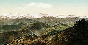
Wyoming ![]() i/waɪˈoʊmɪŋ/ is a state in the mountain region of the Western United States. Wyoming is the 10th most extensive, but the least populous and the 2nd least densely populated of the 50 United States. The western two thirds of the state is covered mostly with the mountain ranges and rangelands in the foothills of the Eastern Rocky Mountains, while the eastern third of the state is high elevation prairie known as the High Plains.
i/waɪˈoʊmɪŋ/ is a state in the mountain region of the Western United States. Wyoming is the 10th most extensive, but the least populous and the 2nd least densely populated of the 50 United States. The western two thirds of the state is covered mostly with the mountain ranges and rangelands in the foothills of the Eastern Rocky Mountains, while the eastern third of the state is high elevation prairie known as the High Plains.
The mountain ranges below are listed by name, county, coordinates, and average elevation as recorded by the U.S. Geological Survey. Sub-ranges are indented below the name of the primary range. Some of these ranges extend into Colorado, Montana, Idaho, and Utah.
- Absaroka Range, Park County, Wyoming, 43°57′40″N 109°20′21″W / 43.96111°N 109.33917°W, el. 13,140 feet (4,010 m)[1]
- Badger Hills, Sheridan County, Wyoming, 44°57′46″N 106°38′39″W / 44.96278°N 106.64417°W, el. 4,455 feet (1,358 m)[2]
- Badlands Hills, Sweetwater County, Wyoming, 41°50′42″N 109°40′11″W / 41.84500°N 109.66972°W, el. 6,417 feet (1,956 m)[3]
- Bald Range, Uinta County, Wyoming, 41°00′42″N 110°06′59″W / 41.01167°N 110.11639°W, el. 8,025 feet (2,446 m)[4]
- Bear Lodge Mountains, Crook County, Wyoming, 44°38′00″N 104°23′02″W / 44.63333°N 104.38389°W, el. 4,508 feet (1,374 m)[5]
- Beaver Creek Hills, Sheridan County, Wyoming, 44°43′21″N 107°03′15″W / 44.72250°N 107.05417°W, el. 4,708 feet (1,435 m)[6]
- Beartooth Mountains; Park County, Wyoming; 45°09′48″N 109°48′29″W / 45.16333°N 109.80806°W; 12,693 feet (3,869 m)[7]
- Bighorn Mountains, Johnson County, Wyoming, 44°30′01″N 107°15′03″W / 44.50028°N 107.25083°W, el. 8,733 feet (2,662 m)[8]
- Bridger Mountains, Fremont County, Wyoming, 43°29′30″N 107°59′02″W / 43.49167°N 107.98389°W, el. 7,109 feet (2,167 m)[9]
- Buck Creek Hills, Niobrara County, Wyoming, 43°08′42″N 104°24′35″W / 43.14500°N 104.40972°W, el. 4,308 feet (1,313 m)[10]
- Buck Creek V S, Big Horn County, Wyoming, 44°16′12″N 107°21′29″W / 44.27000°N 107.35806°W, el. 8,579 feet (2,615 m)[11]
- Castle Gardens, Fremont County, Wyoming, 42°57′13″N 107°40′01″W / 42.95361°N 107.66694°W, el. 5,909 feet (1,801 m)[12]
- Coalbank Hills, Natrona County, Wyoming, 42°55′10″N 107°20′58″W / 42.91944°N 107.34944°W, el. 6,604 feet (2,013 m)[13]
- Cow Creek Breaks, Campbell County, Wyoming, 44°30′48″N 105°19′06″W / 44.51333°N 105.31833°W, el. 4,541 feet (1,384 m)[14]
- Deer Creek Breaks, Campbell County, Wyoming, 44°21′51″N 105°17′47″W / 44.36417°N 105.29639°W, el. 4,439 feet (1,353 m)[15]
- Deer Creek Range, Natrona County, Wyoming, 42°34′46″N 106°09′52″W / 42.57944°N 106.16444°W, el. 8,264 feet (2,519 m)[16]
- Duck Creek Breaks, Campbell County, Wyoming, 44°47′21″N 105°09′51″W / 44.78917°N 105.16417°W, el. 3,835 feet (1,169 m)[17]
- Duck Creek Breaks, Campbell County, Wyoming, 44°44′06″N 105°08′37″W / 44.73500°N 105.14361°W, el. 3,917 feet (1,194 m)[18]
- Edmo Buttes, Fremont County, Wyoming, 43°07′08″N 108°40′27″W / 43.11889°N 108.67417°W, el. 5,420 feet (1,650 m)[19]
- Ferris Mountains, Carbon County, Wyoming, 42°15′23″N 107°14′21″W / 42.25639°N 107.23917°W, el. 9,983 feet (3,043 m)[20]
- Flattop Buttes, Sweetwater County, Wyoming, 42°15′45″N 108°10′14″W / 42.26250°N 108.17056°W, el. 7,326 feet (2,233 m)[21]
- Fort Steele Breaks, Carbon County, Wyoming, 41°48′04″N 106°56′34″W / 41.80111°N 106.94278°W, el. 7,251 feet (2,210 m)[22]
- Freak Mountains, Fremont County, Wyoming, 42°38′50″N 108°47′46″W / 42.64722°N 108.79611°W, el. 8,861 feet (2,701 m)[23]
- Freezeout Mountains, Carbon County, Wyoming, 42°02′09″N 106°23′26″W / 42.03583°N 106.39056°W, el. 7,306 feet (2,227 m)[24]
- Gallatin Range, Park County, Wyoming, 44°55′00″N 110°53′03″W / 44.91667°N 110.88417°W, el. 9,003 feet (2,744 m)[25]
- Gannett Hills, Lincoln County, Wyoming, 42°33′36″N 111°04′14″W / 42.56000°N 111.07056°W, el. 7,907 feet (2,410 m)[26]
- Gas Hills, Fremont County, Wyoming, 42°50′29″N 107°36′00″W / 42.84139°N 107.60000°W, el. 6,371 feet (1,942 m)[27]
- Granite Mountains, Fremont County, Wyoming, 42°31′12″N 107°36′06″W / 42.52000°N 107.60167°W, el. 7,388 feet (2,252 m)[28]
- Green Mountains, Fremont County, Wyoming, 42°22′36″N 107°48′57″W / 42.37667°N 107.81583°W, el. 7,844 feet (2,391 m)[29]
- Gros Ventre Range, Teton County, Wyoming, 43°22′29″N 110°30′04″W / 43.37472°N 110.50111°W, el. 9,997 feet (3,047 m)[30]
- Gumbo Hills, Hot Springs County, Wyoming, 43°45′58″N 108°30′47″W / 43.76611°N 108.51306°W, el. 5,381 feet (1,640 m)[31]
- Hamilton Hills, Niobrara County, Wyoming, 42°56′41″N 104°45′11″W / 42.94472°N 104.75306°W, el. 4,915 feet (1,498 m)[32]
- Harney Hills, Niobrara County, Wyoming, 42°51′48″N 104°51′25″W / 42.86333°N 104.85694°W, el. 5,282 feet (1,610 m)[33]
- Haystack Mountains, Carbon County, Wyoming, 41°55′05″N 107°07′27″W / 41.91806°N 107.12417°W, el. 7,762 feet (2,366 m)[34]
- Haystack Range, Goshen County, Wyoming, 42°20′29″N 104°38′06″W / 42.34139°N 104.63500°W, el. 5,646 feet (1,721 m)[35]
- Haystacks, Natrona County, Wyoming, 42°58′36″N 106°47′18″W / 42.97667°N 106.78833°W, el. 5,843 feet (1,781 m)[36]
- Hells Half Acre, Natrona County, Wyoming, 43°02′17″N 107°05′35″W / 43.03806°N 107.09306°W, el. 5,879 feet (1,792 m)[37]
- Honeycomb Buttes, Sweetwater County, Wyoming, 42°14′18″N 108°36′57″W / 42.23833°N 108.61583°W, el. 7,346 feet (2,239 m)[38]
- Horseshoe Hills, Niobrara County, Wyoming, 42°50′54″N 104°42′22″W / 42.84833°N 104.70611°W, el. 5,269 feet (1,606 m)[39]
- Ishawooa Hills, Park County, Wyoming, 44°15′35″N 109°31′27″W / 44.25972°N 109.52417°W, el. 6,565 feet (2,001 m)[40]
- Jack Morrow Hills, Sweetwater County, Wyoming, 42°10′02″N 109°03′35″W / 42.16722°N 109.05972°W, el. 7,707 feet (2,349 m)[41]
- Kirkland Mountains, Fremont County, Wyoming, 43°09′17″N 109°25′11″W / 43.15472°N 109.41972°W, el. 11,430 feet (3,480 m)[42]
- Laramie Mountains, Albany County, Wyoming, 41°31′36″N 105°29′59″W / 41.52667°N 105.49972°W, el. 8,540 feet (2,600 m)[43]
- Lavender Hills, Teton County, Wyoming, 43°37′54″N 110°26′20″W / 43.63167°N 110.43889°W, el. 8,517 feet (2,596 m)[44]
- Leucite Hills, Sweetwater County, Wyoming, 41°49′19″N 108°59′48″W / 41.82194°N 108.99667°W, el. 7,648 feet (2,331 m)[45]
- Little Mitchell Creek Breaks, Campbell County, Wyoming, 44°30′10″N 105°09′13″W / 44.50278°N 105.15361°W, el. 4,019 feet (1,225 m)[46]
- Medicine Bow Breaks, Carbon County, Wyoming, 41°59′10″N 106°34′16″W / 41.98611°N 106.57111°W, el. 6,709 feet (2,045 m)[47]
- Medicine Lodge Big Game Winter Range, Big Horn County, Wyoming, 44°21′43″N 107°30′04″W / 44.36194°N 107.50111°W, el. 6,637 feet (2,023 m)[48]
- Miller Hills, Converse County, Wyoming, 43°21′11″N 104°57′36″W / 43.35306°N 104.96000°W, el. 4,931 feet (1,503 m)[49]
- Mine Hills, Albany County, Wyoming, 42°15′27″N 105°49′21″W / 42.25750°N 105.82250°W, el. 7,710 feet (2,350 m)[50]
- Mitchell Creek Breaks, Campbell County, Wyoming, 44°32′13″N 105°09′06″W / 44.53694°N 105.15167°W, el. 4,219 feet (1,286 m)[51]
- Moneta Hills, Fremont County, Wyoming, 43°12′23″N 107°44′09″W / 43.20639°N 107.73583°W, el. 5,794 feet (1,766 m)[52]
- Moore Spring Hills, Goshen County, Wyoming, 42°28′19″N 104°34′34″W / 42.47194°N 104.57611°W, el. 5,141 feet (1,567 m)[53]
- Old Woman Creek Hills, Niobrara County, Wyoming, 43°08′23″N 104°18′41″W / 43.13972°N 104.31139°W, el. 4,426 feet (1,349 m)[54]
- Oregon Buttes, Sweetwater County, Wyoming, 42°15′17″N 108°51′27″W / 42.25472°N 108.85750°W, el. 8,606 feet (2,623 m)[55]
- Owl Creek Mountains, Fremont County, Wyoming, 43°28′47″N 108°31′04″W / 43.47972°N 108.51778°W, el. 6,811 feet (2,076 m)[56]
- Owl Hills, Fremont County, Wyoming, 42°22′43″N 107°39′46″W / 42.37861°N 107.66278°W, el. 7,917 feet (2,413 m)[57]
- Pedro Mountains, Carbon County, Wyoming, 42°19′50″N 106°50′51″W / 42.33056°N 106.84750°W, el. 7,812 feet (2,381 m)[58]
- Powder River Breaks, Johnson County, Wyoming, 43°58′34″N 106°15′56″W / 43.97611°N 106.26556°W, el. 4,626 feet (1,410 m)[59]
- Powder River Breaks, Sheridan County, Wyoming, 44°47′50″N 106°03′47″W / 44.79722°N 106.06306°W, el. 3,944 feet (1,202 m)[60]
- Prairie Dog Hills, Campbell County, Wyoming, 44°59′35″N 105°17′15″W / 44.99306°N 105.28750°W, el. 3,770 feet (1,150 m)[61]
- Prospect Mountains, Sublette County, Wyoming, 42°28′37″N 109°08′53″W / 42.47694°N 109.14806°W, el. 8,238 feet (2,511 m)[62]
- Pumpkin Buttes, Campbell County, Wyoming, 43°42′55″N 105°52′21″W / 43.71528°N 105.87250°W, el. 5,945 feet (1,812 m)[63]
- Rattlesnake Hills, Natrona County, Wyoming, 42°49′14″N 107°21′09″W / 42.82056°N 107.35250°W, el. 7,848 feet (2,392 m)[64]
- Rawhide Buttes, Goshen County, Wyoming, 42°34′25″N 104°29′59″W / 42.57361°N 104.49972°W, el. 5,249 feet (1,600 m)[65]
- Red Hills, Converse County, Wyoming, 43°28′04″N 105°15′46″W / 43.46778°N 105.26278°W, el. 4,662 feet (1,421 m)[66]
- Red Hills, Lincoln County, Wyoming, 42°42′47″N 110°04′58″W / 42.71306°N 110.08278°W, el. 7,126 feet (2,172 m)[67]
- Red Hills, Johnson County, Wyoming, 44°03′02″N 106°34′21″W / 44.05056°N 106.57250°W, el. 4,675 feet (1,425 m)[68]
- Red Hills, Campbell County, Wyoming, 44°57′37″N 105°25′15″W / 44.96028°N 105.42083°W, el. 4,301 feet (1,311 m)[69]
- Red Hills, Teton County, Wyoming, 42°21′34″N 107°30′04″W / 42.35944°N 107.50111°W, el. 6,640 feet (2,020 m)[70]
- Red Hills, Sublette County, Wyoming, 43°21′13″N 110°12′54″W / 43.35361°N 110.21500°W, el. 9,754 feet (2,973 m)[71]
- Red Hills, Teton County, Wyoming, 43°37′38″N 110°27′58″W / 43.62722°N 110.46611°W, el. 7,900 feet (2,400 m)[72]
- Red Mountains (Wyoming)-(also a range for Utah), Teton County, Wyoming, 44°15′11″N 110°33′13″W / 44.25306°N 110.55361°W, el. 9,711 feet (2,960 m)[73]
- Richeau Hills, Platte County, Wyoming, 41°48′42″N 105°03′38″W / 41.81167°N 105.06056°W, el. 6,493 feet (1,979 m)[74]
- Rocky Mountains, Teton County, Wyoming, 43°21′30″N 110°55′03″W / 43.35833°N 110.91750°W, el. 7,388 feet (2,252 m)[75]
- Saddleback Hills, Carbon County, Wyoming, 41°44′52″N 106°26′28″W / 41.74778°N 106.44111°W, el. 7,480 feet (2,280 m)[76]
- Salt River Range, Lincoln County, Wyoming, 42°45′01″N 110°50′03″W / 42.75028°N 110.83417°W, el. 7,336 feet (2,236 m)[77]
- Sand Hills, Carbon County, Wyoming, 41°49′05″N 106°32′41″W / 41.81806°N 106.54472°W, el. 7,218 feet (2,200 m)[78]
- Sand Hills, Fremont County, Wyoming, 43°15′38″N 108°13′20″W / 43.26056°N 108.22222°W, el. 4,928 feet (1,502 m)[79]
- Sand Hills, Fremont County, Wyoming, 42°54′00″N 108°44′24″W / 42.90000°N 108.74000°W, el. 5,758 feet (1,755 m)[80]
- Savage Hills, Carbon County, Wyoming, 41°40′45″N 106°55′29″W / 41.67917°N 106.92472°W, el. 6,755 feet (2,059 m)[81]
- Seaman Hills, Niobrara County, Wyoming, 42°59′38″N 104°14′16″W / 42.99389°N 104.23778°W, el. 4,685 feet (1,428 m)[82]
- Seminoe Mountains, Carbon County, Wyoming, 42°09′04″N 106°49′31″W / 42.15111°N 106.82528°W, el. 7,431 feet (2,265 m)[83]
- Session Mountains, Uinta County, Wyoming, 41°33′41″N 111°00′52″W / 41.56139°N 111.01444°W, el. 6,827 feet (2,081 m)[84]
- Seventy-Seven Hills, Niobrara County, Wyoming, 42°51′17″N 104°36′58″W / 42.85472°N 104.61611°W, el. 5,508 feet (1,679 m)[85]
- Shamrock Hills, Carbon County, Wyoming, 41°54′47″N 107°25′29″W / 41.91306°N 107.42472°W, el. 6,959 feet (2,121 m)[86]
- Sheep Mountain, Big Horn County, Wyoming, 44°36′04″N 108°07′05″W / 44.60111°N 108.11806°W, el. 4,826 feet (1,471 m)[87]
- Sherman Mountains, Albany County, Wyoming, 41°11′45″N 105°22′57″W / 41.19583°N 105.38250°W, el. 8,468 feet (2,581 m)[88]
- Sherrill Hills, Niobrara County, Wyoming, 42°54′23″N 104°04′23″W / 42.90639°N 104.07306°W, el. 4,541 feet (1,384 m)[89]
- Shirley Mountains, Carbon County, Wyoming, 42°06′25″N 106°35′51″W / 42.10694°N 106.59750°W, el. 8,077 feet (2,462 m)[90]
- Sierra Madre, Carbon County, Wyoming, 41°11′21″N 107°02′50″W / 41.18917°N 107.04722°W, el. 10,961 feet (3,341 m)[91]
- Snake River Range, Teton County, Wyoming, 43°24′57″N 110°57′43″W / 43.41583°N 110.96194°W, el. 10,025 feet (3,056 m)[92]
- Snowy Range, Albany County, Wyoming, 41°20′52″N 106°19′34″W / 41.34778°N 106.32611°W, el. 11,729 feet (3,575 m)[93]
- Sublette Range, Lincoln County, Wyoming, 42°23′07″N 111°01′14″W / 42.38528°N 111.02056°W, el. 7,848 feet (2,392 m)[94]
- T A Hills, Johnson County, Wyoming, 44°08′12″N 106°39′42″W / 44.13667°N 106.66167°W, el. 5,161 feet (1,573 m)[95]
- Tepee Mountains, Sweetwater County, Wyoming, 41°00′09″N 109°10′05″W / 41.00250°N 109.16806°W, el. 7,339 feet (2,237 m)[96]
- Teton Range, Teton County, Wyoming, 43°45′05″N 110°53′03″W / 43.75139°N 110.88417°W, el. 9,252 feet (2,820 m)[97]
- The Brakes, Crook County, Wyoming, 44°36′45″N 104°06′48″W / 44.61250°N 104.11333°W, el. 3,832 feet (1,168 m)[98]
- The Breaks, Carbon County, Wyoming, 41°59′11″N 106°24′56″W / 41.98639°N 106.41556°W, el. 6,621 feet (2,018 m)[99]
- The Palisades, Park County, Wyoming, 44°36′05″N 109°21′03″W / 44.60139°N 109.35083°W, el. 8,274 feet (2,522 m)[100]
- The Sand Hills, Carbon County, Wyoming, 41°26′22″N 107°32′46″W / 41.43944°N 107.54611°W, el. 7,369 feet (2,246 m)[101]
- The Vees, Washakie County, Wyoming, 43°50′41″N 107°13′26″W / 43.84472°N 107.22389°W, el. 6,355 feet (1,937 m)[102]
- Three Brothers Mountains, Teton County, Wyoming, 44°37′59″N 110°53′16″W / 44.63306°N 110.88778°W, el. 7,116 feet (2,169 m)[103]
- Tunp Range, Lincoln County, Wyoming, 42°13′17″N 110°48′23″W / 42.22139°N 110.80639°W, el. 8,346 feet (2,544 m)[104]
- Twin Hills, Goshen County, Wyoming, 42°24′35″N 104°33′48″W / 42.40972°N 104.56333°W, el. 4,816 feet (1,468 m)[105]
- Twin Mountains, Laramie County, Wyoming, 41°02′54″N 105°16′03″W / 41.04833°N 105.26750°W, el. 8,081 feet (2,463 m)[106]
- Wanker Hills, Niobrara County, Wyoming, 42°41′31″N 104°34′16″W / 42.69194°N 104.57111°W, el. 5,669 feet (1,728 m)[107]
- Washburn Range, Park County, Wyoming, 44°50′08″N 110°34′11″W / 44.83556°N 110.56972°W, el. 9,212 feet (2,808 m)[108]
- Wildcat Hills, Goshen County, Wyoming, 42°30′23″N 104°37′34″W / 42.50639°N 104.62611°W, el. 5,679 feet (1,731 m)[109]
- Wind River Range, Sublette County, Wyoming, 43°00′00″N 109°30′03″W / 43.00000°N 109.50083°W, el. 10,709 feet (3,264 m)[110]
- Wyoming Range, Lincoln County, Wyoming, 42°44′02″N 110°36′46″W / 42.73389°N 110.61278°W, el. 9,593 feet (2,924 m)[111]
See also
- Mountains and mountain ranges of Yellowstone National Park
- Mountain passes in Wyoming (A-J)
- Mountain passes in Wyoming (K-Y)
Notes
- ↑ "Absaroka Range". Geographic Names Information System. United States Geological Survey.
- ↑ "Badger Hills". Geographic Names Information System. United States Geological Survey.
- ↑ "Badlands Hills". Geographic Names Information System. United States Geological Survey.
- ↑ "Bald Range". Geographic Names Information System. United States Geological Survey.
- ↑ "Bear Lodge Mountains". Geographic Names Information System. United States Geological Survey.
- ↑ "Beaver Creek Hills". Geographic Names Information System. United States Geological Survey.
- ↑ "Beartooth Mountains". Geographic Names Information System. United States Geological Survey.
- ↑ "Bighorn Mountains". Geographic Names Information System. United States Geological Survey.
- ↑ "Bridger Mountains". Geographic Names Information System. United States Geological Survey.
- ↑ "Buck Creek Hills". Geographic Names Information System. United States Geological Survey.
- ↑ "Buck Creek V S". Geographic Names Information System. United States Geological Survey.
- ↑ "Castle Gardens". Geographic Names Information System. United States Geological Survey.
- ↑ "Coalbank Hills". Geographic Names Information System. United States Geological Survey.
- ↑ "Cow Creek Breaks". Geographic Names Information System. United States Geological Survey.
- ↑ "Deer Creek Breaks". Geographic Names Information System. United States Geological Survey.
- ↑ "Deer Creek Range". Geographic Names Information System. United States Geological Survey.
- ↑ "Duck Creek Breaks". Geographic Names Information System. United States Geological Survey.
- ↑ "Duck Creek Breaks". Geographic Names Information System. United States Geological Survey.
- ↑ "Edmo Buttes". Geographic Names Information System. United States Geological Survey.
- ↑ "Ferris Mountains". Geographic Names Information System. United States Geological Survey.
- ↑ "Flattop Buttes". Geographic Names Information System. United States Geological Survey.
- ↑ "Fort Steele Breaks". Geographic Names Information System. United States Geological Survey.
- ↑ "Freak Mountains". Geographic Names Information System. United States Geological Survey.
- ↑ "Freezeout Mountains". Geographic Names Information System. United States Geological Survey.
- ↑ "Gallatin Range". Geographic Names Information System. United States Geological Survey.
- ↑ "Gannett Hills". Geographic Names Information System. United States Geological Survey.
- ↑ "Gas Hills". Geographic Names Information System. United States Geological Survey.
- ↑ "Granite Mountains". Geographic Names Information System. United States Geological Survey.
- ↑ "Green Mountains". Geographic Names Information System. United States Geological Survey.
- ↑ "Gros Ventre Range". Geographic Names Information System. United States Geological Survey.
- ↑ "Gumbo Hills". Geographic Names Information System. United States Geological Survey.
- ↑ "Hamilton Hills". Geographic Names Information System. United States Geological Survey.
- ↑ "Harney Hills". Geographic Names Information System. United States Geological Survey.
- ↑ "Haystack Mountains". Geographic Names Information System. United States Geological Survey.
- ↑ "Haystack Range". Geographic Names Information System. United States Geological Survey.
- ↑ "Haystacks". Geographic Names Information System. United States Geological Survey.
- ↑ "Hells Half Acre". Geographic Names Information System. United States Geological Survey.
- ↑ "Honeycomb Buttes". Geographic Names Information System. United States Geological Survey.
- ↑ "Horseshoe Hills". Geographic Names Information System. United States Geological Survey.
- ↑ "Ishawooa Hills". Geographic Names Information System. United States Geological Survey.
- ↑ "Jack Morrow Hills". Geographic Names Information System. United States Geological Survey.
- ↑ "Kirkland Mountains". Geographic Names Information System. United States Geological Survey.
- ↑ "Laramie Mountains". Geographic Names Information System. United States Geological Survey.
- ↑ "Lavender Hills". Geographic Names Information System. United States Geological Survey.
- ↑ "Leucite Hills". Geographic Names Information System. United States Geological Survey.
- ↑ "Little Mitchell Creek Breaks". Geographic Names Information System. United States Geological Survey.
- ↑ "Medicine Bow Breaks". Geographic Names Information System. United States Geological Survey.
- ↑ "Medicine Lodge Big Game Winter Range". Geographic Names Information System. United States Geological Survey.
- ↑ "Miller Hills". Geographic Names Information System. United States Geological Survey.
- ↑ "Mine Hills". Geographic Names Information System. United States Geological Survey.
- ↑ "Mitchell Creek Breaks". Geographic Names Information System. United States Geological Survey.
- ↑ "Moneta Hills". Geographic Names Information System. United States Geological Survey.
- ↑ "Moore Spring Hills". Geographic Names Information System. United States Geological Survey.
- ↑ "Old Woman Creek Hills". Geographic Names Information System. United States Geological Survey.
- ↑ "Oregon Buttes". Geographic Names Information System. United States Geological Survey.
- ↑ "Owl Creek Mountains". Geographic Names Information System. United States Geological Survey.
- ↑ "Owl Hills". Geographic Names Information System. United States Geological Survey.
- ↑ "Pedro Mountains". Geographic Names Information System. United States Geological Survey.
- ↑ "Powder River Breaks". Geographic Names Information System. United States Geological Survey.
- ↑ "Powder River Breaks". Geographic Names Information System. United States Geological Survey.
- ↑ "Prairie Dog Hills". Geographic Names Information System. United States Geological Survey.
- ↑ "Prospect Mountains". Geographic Names Information System. United States Geological Survey.
- ↑ "Pumpkin Buttes". Geographic Names Information System. United States Geological Survey.
- ↑ "Rattlesnake Hills". Geographic Names Information System. United States Geological Survey.
- ↑ "Rawhide Buttes". Geographic Names Information System. United States Geological Survey.
- ↑ "Red Hills". Geographic Names Information System. United States Geological Survey.
- ↑ "Red Hills". Geographic Names Information System. United States Geological Survey.
- ↑ "Red Hills". Geographic Names Information System. United States Geological Survey.
- ↑ "Red Hills". Geographic Names Information System. United States Geological Survey.
- ↑ "Red Hills". Geographic Names Information System. United States Geological Survey.
- ↑ "Red Hills". Geographic Names Information System. United States Geological Survey.
- ↑ "Red Hills". Geographic Names Information System. United States Geological Survey.
- ↑ "Red Mountains". Geographic Names Information System. United States Geological Survey.
- ↑ "Richeau Hills". Geographic Names Information System. United States Geological Survey.
- ↑ "Rocky Mountains". Geographic Names Information System. United States Geological Survey.
- ↑ "Saddleback Hills". Geographic Names Information System. United States Geological Survey.
- ↑ "Salt River Range". Geographic Names Information System. United States Geological Survey.
- ↑ "Sand Hills". Geographic Names Information System. United States Geological Survey.
- ↑ "Sand Hills". Geographic Names Information System. United States Geological Survey.
- ↑ "Sand Hills". Geographic Names Information System. United States Geological Survey.
- ↑ "Savage Hills". Geographic Names Information System. United States Geological Survey.
- ↑ "Seaman Hills". Geographic Names Information System. United States Geological Survey.
- ↑ "Seminoe Mountains". Geographic Names Information System. United States Geological Survey.
- ↑ "Session Mountains". Geographic Names Information System. United States Geological Survey.
- ↑ "Seventy-Seven Hills". Geographic Names Information System. United States Geological Survey.
- ↑ "Shamrock Hills". Geographic Names Information System. United States Geological Survey.
- ↑ "Sheep Mountain". Geographic Names Information System. United States Geological Survey.
- ↑ "Sherman Mountains". Geographic Names Information System. United States Geological Survey.
- ↑ "Sherrill Hills". Geographic Names Information System. United States Geological Survey.
- ↑ "Shirley Mountains". Geographic Names Information System. United States Geological Survey.
- ↑ "Sierra Madre". Geographic Names Information System. United States Geological Survey.
- ↑ "Snake River Range". Geographic Names Information System. United States Geological Survey.
- ↑ "Snowy Range". Geographic Names Information System. United States Geological Survey.
- ↑ "Sublette Range". Geographic Names Information System. United States Geological Survey.
- ↑ "T A Hills". Geographic Names Information System. United States Geological Survey.
- ↑ "Tepee Mountains". Geographic Names Information System. United States Geological Survey.
- ↑ "Teton Range". Geographic Names Information System. United States Geological Survey.
- ↑ "The Brakes". Geographic Names Information System. United States Geological Survey.
- ↑ "The Breaks". Geographic Names Information System. United States Geological Survey.
- ↑ "The Palisades". Geographic Names Information System. United States Geological Survey.
- ↑ "The Sand Hills". Geographic Names Information System. United States Geological Survey.
- ↑ "The Vees". Geographic Names Information System. United States Geological Survey.
- ↑ "Three Brothers Mountains". Geographic Names Information System. United States Geological Survey.
- ↑ "Tunp Range". Geographic Names Information System. United States Geological Survey.
- ↑ "Twin Hills". Geographic Names Information System. United States Geological Survey.
- ↑ "Twin Mountains". Geographic Names Information System. United States Geological Survey.
- ↑ "Wanker Hills". Geographic Names Information System. United States Geological Survey.
- ↑ "Washburn Range". Geographic Names Information System. United States Geological Survey.
- ↑ "Wildcat Hills". Geographic Names Information System. United States Geological Survey.
- ↑ "Wind River Range". Geographic Names Information System. United States Geological Survey.
- ↑ "Wyoming Range". Geographic Names Information System. United States Geological Survey.
Cheyenne (capital) | |
| Topics |
|
| Society |
|
| Regions | |
| Cities | |
| Counties | |