List of lighthouses in Trinidad and Tobago
This is a list of lighthouses in Trinidad and Tobago. [1] [2]
Trinidad Lighthouses
| Name | Image | Year built | Coordinates | Class of Light | Focal height | NGA number | Admiralty number | Range nml |
|---|---|---|---|---|---|---|---|---|
| Brigand Hill Lighthouse | 1958 | 10°29′44.2″N 61°04′04.6″W / 10.495611°N 61.067944°W | Fl (2+1) W 30s. | 217 metres (712 ft) | 16108 | J5915 | 20 | |
| Chacachacare Lighthouse | 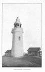 | 1897 | 10°41′56.6″N 61°45′09.6″W / 10.699056°N 61.752667°W | Fl W 10s. | 251 metres (823 ft) | 16256 | J5846 | 26 |
| Chupara Point Lighthouse | n/a | 10°48′42.9″N 61°21′51.2″W / 10.811917°N 61.364222°W | Fl (2) W 10s. | 99 metres (325 ft) | 16264.7 | J5843 | 16 | |
| Espolon Point Lighthouse | n/a | 10°39′52.6″N 61°39′57.6″W / 10.664611°N 61.666000°W | Fl W 4s. | 13 metres (43 ft) | 16236 | 5856 | 8 | |
| Galeota Point Lighthouse | n/a | 10°08′18.7″N 60°59′29.1″W / 10.138528°N 60.991417°W | Fl W 5s. | 87 metres (285 ft) | 16109 | J5914 | 13 | |
| Galera Point Lighthouse |  | 1897 | 10°50′03.0″N 60°54′35.2″W / 10.834167°N 60.909778°W | Oc W 10s. | 43 metres (141 ft) | 16266 | J5842 | 16 |
| Grieger Channel Range Front Lighthouse | n/a | 10°39′16.4″N 61°31′17.1″W / 10.654556°N 61.521417°W | Oc W 4s. | 41 metres (135 ft) | 16190 | J5884.24 | 10 | |
| Grieger Channel Range Rear Lighthouse | n/a | 10°39′19.2″N 61°31′11.8″W / 10.655333°N 61.519944°W | Iso W 2s. | 119 metres (390 ft) | 16190.1 | J5884.25 | 11 | |
| La Cerriere Lighthouse | n/a | 10°19′37.1″N 61°27′11.4″W / 10.326972°N 61.453167°W | Fl W 2.5s. | 71 metres (233 ft) | 16152 | J5895 | 17 | |
| Punta del Arenal Lighthouse | 1870 est. | 10°02′58.6″N 61°55′39.0″W / 10.049611°N 61.927500°W | Fl W 7.5s. | 22 metres (72 ft) | 16116 | J5912 | 16 | |
| Taparo Point Lighthouse | n/a | 10°03′30.0″N 61°37′36.0″W / 10.058333°N 61.626667°W | Fl (3) W 15s. | 69 metres (226 ft) | 16111 | J5913.4 | 13 | |
| Savoneeta Range Front Lighthouse | n/a | 10°24′14.4″N 61°29′24.2″W / 10.404000°N 61.490056°W | Fl W 2s. | 30 metres (98 ft) | 16180 | J5891 | 8 | |
| Savoneeta Range Rear Lighthouse | n/a | 12°24′34.3″N 61°29′00.7″W / 12.409528°N 61.483528°W | Oc W 4s. | 41 metres (135 ft) | 16184 | J5891.1 | 8 | |
| Sea Lots Channel Range Front Lighthouse | n/a | 10°38′30.8″N 61°29′41.8″W / 10.641889°N 61.494944°W | Oc W 10s. | 26 metres (85 ft) | 16197 | J5882 | 6 | |
| Sea Lots Channel Range Rear Lighthouse | n/a | 10°38′36.9″N 61°29′31.9″W / 10.643583°N 61.492194°W | Fl W 2s. | 39 metres (128 ft) | 16197.1 | J5882.1 | 6 | |
Tobago Lighthouses
| Name | Built | Coordinates | Class of Light | Focal height | NGA number | Admiralty number | Range nml |
|---|---|---|---|---|---|---|---|
| Crown Point Lighthouse | n/a | 15°08′54.0″N 60°50′42.0″W / 15.148333°N 60.845000°W | Fl (4) W 20s. | 35 metres (115 ft) | 15200 | J5841.5 | 16 |
| Scarborough Lighthouse | n/a | 11°10′38.4″N 60°43′36.2″W / 11.177333°N 60.726722°W | Fl (2) W 20s. | 141 metres (463 ft) | 15184 | J5838 | 20 |
See also
References
- ↑ Trinidad and Tobago The Lighthouse Directory. University of North Carolina at Chapel Hill. Retrieved 2 September 2016
- ↑ NGA List of Lights – Pub.110 Retrieved 22 September 2016
| Types |
| _-_cropped.jpg) | ||||||||||
|---|---|---|---|---|---|---|---|---|---|---|---|---|
| Fixtures | ||||||||||||
| Maintenance |
| |||||||||||
| Individual lighthouses |
| |||||||||||
| Museums |
| |||||||||||
| Other organizations | ||||||||||||
| ||||||||||||
This article is issued from Wikipedia - version of the 12/2/2016. The text is available under the Creative Commons Attribution/Share Alike but additional terms may apply for the media files.