List of historic landmarks in Albuquerque, New Mexico

This is a list of historic landmarks in Albuquerque, New Mexico, as designated by the City Council. To date 20 individual properties (two of which are no longer standing) have been so designated.[1] Historic landmarks may not be demolished or significantly altered without approval from the Landmarks and Urban Conservation Commission.[2]
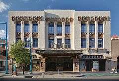
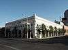
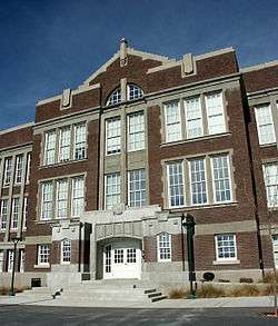
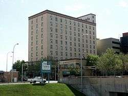
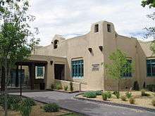
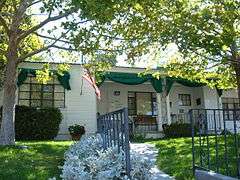
Historic landmarks

Name Image Location Notes[3]
AT&SF Locomotive 2926 1600 12th St. NW
35°6′11″N 106°39′15″W / 35.10306°N 106.65417°W / 35.10306; -106.65417 (AT&SF Locomotive 2926)
SR 1975
NR 2007
AT&SF Railway Fire Station 1st and 2nd SW
35°4′36″N 106°39′01″W / 35.07667°N 106.65028°W / 35.07667; -106.65028 (AT&SF Railway Fire Station)
Heights Community Center 823 Buena Vista Dr. SE
35°4′24″N 106°37′28″W / 35.07333°N 106.62444°W / 35.07333; -106.62444 (Heights Community Center)
Highland/Hudson Hotel 202 Central Ave. SE
35°5′1″N 106°38′44″W / 35.08361°N 106.64556°W / 35.08361; -106.64556 (Highland/Hudson Hotel)
Jones Motor Company 3222 Central Ave. SE
35°4′38″N 106°37′9″W / 35.07722°N 106.61917°W / 35.07722; -106.61917 (Jones Motor Company)
SR 1993
NR 1993
KiMo Theater 423 Central Ave. NW
35°5′6″N 106°39′7″W / 35.08500°N 106.65194°W / 35.08500; -106.65194 (KiMo Theater)
SR 1976
NR 1977
Las Mañanitas 1800 Rio Grande Blvd. NW
35°6′38″N 106°40′21″W / 35.11056°N 106.67250°W / 35.11056; -106.67250 (Las Mañanitas)
Occidental Life Building 119 3rd St. SW
35°5′1″N 106°39′1″W / 35.08361°N 106.65028°W / 35.08361; -106.65028 (Occidental Life Building)
SR 1973
NR 1978
Old Airport Terminal 2920 Yale Blvd. SE
35°2′52″N 106°37′14″W / 35.04778°N 106.62056°W / 35.04778; -106.62056 (Old Airport Terminal)
SR 1976
NR 1989
Old Albuquerque High School Central and Broadway NE
35°5′3″N 106°38′38″W / 35.08417°N 106.64389°W / 35.08417; -106.64389 (Old Albuquerque High School)
SR 1977
Old Hilton Hotel 125 2nd St. NW
35°5′6″N 106°38′56″W / 35.08500°N 106.64889°W / 35.08500; -106.64889 (Andaluz Hotel {Old Hilton Hotel))
SR 1983
NR 1984
Old Main Library 423 Central Ave. NE
35°5′2″N 106°38′33″W / 35.08389°N 106.64250°W / 35.08389; -106.64250 (Old Main Library)
SR 1975
Ernie Pyle House 900 Girard Blvd. SE
35°4′13″N 106°36′45″W / 35.07028°N 106.61250°W / 35.07028; -106.61250 (Ernie Pyle House)
SR 1997
NR 1997
Roosevelt Park Coal and Spruce SE
35°4′35″N 106°37′49″W / 35.07639°N 106.63028°W / 35.07639; -106.63028 (Roosevelt Park)
SR 1996
NR 1996
Rosenwald Building 320 Central Ave. SW
35°5′3″N 106°39′3″W / 35.08417°N 106.65083°W / 35.08417; -106.65083 (Rosenwald Building)
SR 1978
NR 1978
Skinner Building 722 Central Ave. SW
35°5′6″N 106°39′20″W / 35.08500°N 106.65556°W / 35.08500; -106.65556 (Skinner Building)
SR 1980
NR 1980
Sunshine Building 120 Central Ave. SW
35°5′2″N 106°38′57″W / 35.08389°N 106.64917°W / 35.08389; -106.64917 (Sunshine Building)
SR 1985
Whittlesey House 201 Highland Park Cir. SE
35°4′54″N 106°38′21″W / 35.08167°N 106.63917°W / 35.08167; -106.63917 (Whittlesey House)
SR 1975

Former landmarks

Name Image Location Notes
Anson Flats 816-894 5th St. NW
35°5′35″N 106°39′4″W / 35.09306°N 106.65111°W / 35.09306; -106.65111 (Anson Flats (former landmark))
Burned in 1996
AT&SF Railway Passenger Depot 314 1st St. SW
35°4′56″N 106°38′52″W / 35.08222°N 106.64778°W / 35.08222; -106.64778 (AT&SF Railway Passenger Depot (former landmark))
Burned in 1993

See also

References

  1. "Historic Landmarks". City of Albuquerque Planning Department. Retrieved 3 September 2012.
  2. "Landmarks and Urban Conservation Commission". City of Albuquerque Planning Department. Retrieved 3 September 2012.
  3. "Properties by County" (PDF). New Mexico Department of Cultural Affairs. Retrieved 22 May 2011.
This article is issued from Wikipedia - version of the 5/21/2016. The text is available under the Creative Commons Attribution/Share Alike but additional terms may apply for the media files.