| Name |
Address |
Municipality |
PC |
Coordinates |
IDF |
IDP |
IDM |
 |
Image |
|---|
| Belmont Road Main Gatehouse, Royal Roads University formerly Royal Roads Military College |
13 College Dr Victoria, BC V9C, Canada Hatley Park National Historic Site |
Colwood |
|
48°26′13″N 123°27′40″W / 48.4369°N 123.4612°W / 48.4369; -123.4612 (Belmont Road Main Gatehouse) |
2840 |
|
|
|
 |
| Cole Island |
Cole Island |
Colwood |
V9B |
48°27′13″N 123°27′04″W / 48.4535°N 123.451°W / 48.4535; -123.451 (Cole Island) |
|
12074 |
|
|
|
| Cow Barn and Dairy RR6 |
Hatley Park National Historic Site |
Colwood |
|
48°25′49″N 123°28′30″W / 48.4304°N 123.475°W / 48.4304; -123.475 (Cow Barn and Dairy RR6) |
2841 |
|
|
|
|
| Defence Electric Light Number 1 |
Fort Rodd Hill Road |
Colwood |
|
48°25′55″N 123°27′00″W / 48.4319°N 123.45°W / 48.4319; -123.45 (Defence Electric Light Number 1) |
4295 |
|
|
|

More images |
| Fisgard Lighthouse and Dwelling |
603 Fort Rodd Hill Road |
Colwood |
|
48°25′49″N 123°26′51″W / 48.4304°N 123.4476°W / 48.4304; -123.4476 (Fisgard Lighthouse National Historic Site) |
1146
1253 |
|
|
|

More images |
| Fort Rodd Hill National Historic Site of Canada |
603 Fort Rodd Hill Road |
Colwood |
V9C |
48°25′57″N 123°27′00″W / 48.4324°N 123.45°W / 48.4324; -123.45 (Fort Rodd Hill National Historic Site of Canada) |
13469 |
|
|
|
 |
| Fort Rodd Hill National Historic Site, Lower Battery, Casemate Barracks (6 Buildings) |
|
Colwood |
|
48°25′55″N 123°27′00″W / 48.4319°N 123.45°W / 48.4319; -123.45 (Fort Rodd Hill National Historic Site, Lower Battery, Casemate Barracks (6 Buildings)) |
4296 |
|
|
|
|
| Fort Rodd Hill , Battery Commander’s Post |
Fort Rodd Hill Road |
Colwood |
|
48°25′55″N 123°27′00″W / 48.4319°N 123.45°W / 48.4319; -123.45 (Fort Rodd Hill, Battery Commander’s Post) |
9741 |
|
|
|
|
| Fort Rodd Hill, Canteen |
Fort Rodd Hill Road |
Colwood |
|
48°25′55″N 123°27′00″W / 48.4319°N 123.45°W / 48.4319; -123.45 (Fort Rodd Hill, Canteen) |
4346 |
|
|
|
|
| Fortress Plotting Room |
Fort Rodd Hill Road |
Colwood |
|
48°25′55″N 123°27′00″W / 48.4319°N 123.45°W / 48.4319; -123.45 (Fortress Plotting Room) |
4292 |
|
|
|
|
| Gatehouse Lodge |
Hatley Park National Historic Site |
Colwood |
|
48°26′20″N 123°28′48″W / 48.439°N 123.48°W / 48.439; -123.48 (Gatehouse Lodge) |
11288 |
|
|
|
|
| Grant Block, Building 24, Royal Roads University formerly Royal Roads Military College |
Hatley Park National Historic Site |
Colwood |
|
48°26′00″N 123°28′59″W / 48.4333°N 123.483°W / 48.4333; -123.483 (Grant Block, Building 24, Royal Roads University formerly Royal Roads Military College) |
3664 |
|
|
|

More images |
| Guardhouse, Lower Battery |
Fort Rodd Hill Road |
Colwood |
|
48°25′55″N 123°27′00″W / 48.4319°N 123.45°W / 48.4319; -123.45 (Guardhouse, Lower Battery) |
4286 |
|
|
|
|
| Guardhouse, Upper Battery |
Fort Rodd Hill Road |
Colwood |
|
48°25′55″N 123°27′00″W / 48.4319°N 123.45°W / 48.4319; -123.45 (Guardhouse, Upper Battery) |
4283 |
|
|
|

More images |
| Gun Emplacement and Magazine, Lower Battery |
Fort Rodd Hill Road |
Colwood |
|
48°26′N 123°29′W / 48.43°N 123.48°W / 48.43; -123.48 (Gun Emplacement and Magazine, Lower Battery) |
4290 |
|
|
|
|
| Gun Emplacement and Magazine, Upper Battery |
Fort Rodd Hill Road |
Colwood |
|
48°26′N 123°29′W / 48.43°N 123.48°W / 48.43; -123.48 (Gun Emplacement and Magazine, Upper Battery) |
4289 |
|
|
|

More images |
| Gun Emplacement, Magazine and Directors Tower, Belmont Battery Classified Federal Heritage Building |
Fort Rodd Hill Road |
Colwood |
V9C |
|
3145 |
|
|
|

More images |
| Gymnasium RR22, Royal Roads University formerly Royal Roads Military College |
Hatley Park National Historic Site |
Colwood |
|
48°25′49″N 123°28′30″W / 48.4304°N 123.475°W / 48.4304; -123.475 (Gymnasium RR22) |
2844 |
|
|
|
|
| Hatley Park National Historic Site / Former Royal Roads Military College/Royal Roads University |
2005 Sooke Road |
Colwood |
V9C |
48°26′06″N 123°28′23″W / 48.4351°N 123.473°W / 48.4351; -123.473 (Hatley Park / Former Royal Roads Military College National Historic Site of Canada) |
15749 |
|
|
|
|
| Journey`s End (House) - Built by Jesse Muriel Dunsmuir, completed 1932 |
Ocean Boulevard |
Colwood |
|
48°26′07″N 123°27′04″W / 48.4354°N 123.4510°W / 48.4354; -123.4510 (House) |
4375 |
|
|
|
|
| Nixon Block RR24A, Royal Roads University formerly Royal Roads Military College |
Hatley Park National Historic Site |
Colwood |
|
48°25′49″N 123°28′30″W / 48.4304°N 123.475°W / 48.4304; -123.475 (Nixon Block RR24A) |
2843 |
|
|
|
|
| Searchlight Engine Room |
603, Fort Rodd Hill Road |
Colwood |
|
48°25′55″N 123°27′00″W / 48.4319°N 123.45°W / 48.4319; -123.45 (Searchlight Engine Room) |
4279 |
|
|
|
|
| Searchlight N° 7 |
Fort Rodd Hill Road |
Colwood |
|
48°25′55″N 123°27′00″W / 48.4319°N 123.45°W / 48.4319; -123.45 (Searchlight N° 7) |
4281 |
|
|
|
|
| Stable / Garage RR4 Royal Roads University formerly Royal Roads Military College |
Hatley Park National Historic Site |
Colwood |
|
48°25′49″N 123°28′30″W / 48.4304°N 123.475°W / 48.4304; -123.475 (Stable / Garage RR4) |
2842 |
|
|
|
|
| Swimming Pool RR22A Royal Roads University formerly Royal Roads Military College |
Hatley Park National Historic Site |
Colwood |
|
48°25′49″N 123°28′30″W / 48.4304°N 123.475°W / 48.4304; -123.475 (Swimming Pool RR22A) |
2845 |
|
|
|
|
| Warrant Officer's Quarters Royal Roads University formerly Royal Roads Military College |
Hatley Park National Historic Site |
Colwood |
|
48°25′55″N 123°27′00″W / 48.4319°N 123.45°W / 48.4319; -123.45 (Warrant Officer's Quarters) |
4277 |
|
|
|
|
| Building 34 Nelles Block |
|
Esquimalt |
|
48°26′11″N 123°25′05″W / 48.4364°N 123.418°W / 48.4364; -123.418 (Building 34) |
10070 |
|
|
|
|
| Building D1 Base Commander’s Residence |
|
Esquimalt |
|
48°25′48″N 123°26′06″W / 48.43°N 123.435°W / 48.43; -123.435 (Building D1) |
3983 |
|
|
|
|
| Building D101 Admiral’s Residence |
Hospital Rd Dockyard |
Esquimalt |
|
48°25′51″N 123°26′15″W / 48.4307°N 123.4374°W / 48.4307; -123.4374 (Building D101) |
3147 |
|
|
|
|
| Building D109 Former Sail Loft and Oil Stores |
|
Esquimalt |
|
48°25′48″N 123°26′06″W / 48.43°N 123.435°W / 48.43; -123.435 (Building D109) |
4064 |
|
|
|
|
| Building D175 Drydock Pumphouse |
|
Esquimalt |
|
48°25′48″N 123°26′06″W / 48.43°N 123.435°W / 48.43; -123.435 (Building D175) |
2792 |
|
|
|
|
| Building D211 Clothing and Receiving Stores |
|
Esquimalt |
|
48°25′48″N 123°26′06″W / 48.43°N 123.435°W / 48.43; -123.435 (Building D211) |
3980 |
|
|
|
|
| Building D214 Dockyard Guardhouse |
|
Esquimalt |
|
48°25′48″N 123°26′06″W / 48.43°N 123.435°W / 48.43; -123.435 (Building D214) |
2793 |
|
|
|
|
| Building D26 Former Royal Navy Prison |
|
Esquimalt |
|
48°25′48″N 123°26′06″W / 48.43°N 123.435°W / 48.43; -123.435 (Building D26) |
3984 |
|
|
|
|
| Building D38 Stone Frigate |
|
Esquimalt |
|
48°25′48″N 123°26′06″W / 48.43°N 123.435°W / 48.43; -123.435 (Building D38) |
4341 |
|
|
|
|
| Building D51 Factory |
|
Esquimalt |
|
48°25′48″N 123°26′06″W / 48.43°N 123.435°W / 48.43; -123.435 (Building D51) |
3982 |
|
|
|
|
| Building D70 Dockyard Main Office |
|
Esquimalt |
|
48°25′48″N 123°26′06″W / 48.43°N 123.435°W / 48.43; -123.435 (Building D70) |
2785 |
|
|
|
|
| Building D75-D76 Rum and Salt Meats Stores |
|
Esquimalt |
|
48°25′48″N 123°26′06″W / 48.43°N 123.435°W / 48.43; -123.435 (Building D75-D76) |
3978 |
|
|
|

More images |
| Building D77 Creery Building Former Ordnance Stores |
|
Esquimalt |
|
48°26′18″N 123°25′48″W / 48.4384°N 123.43°W / 48.4384; -123.43 (Building D77) |
3979 |
|
|
|
|
| Building D80, former Cordage / Furniture Stores Recognized Federal Heritage Building |
|
Esquimalt |
V9A |
48°25′48″N 123°26′06″W / 48.43°N 123.435°W / 48.43; -123.435 (Building D80, former Cordage / Furniture Stores Recognized Federal Heritage Building) |
3981 |
|
|
|
|
| CFB Esquimalt, Bickford Tower, Building D118 |
|
Esquimalt |
|
48°25′48″N 123°26′06″W / 48.43°N 123.435°W / 48.43; -123.435 (CFB Esquimalt, Bickford Tower, Building D118) |
3900 |
|
|
|
|
| CFB Esquimalt, Dockyard, Electrical Shop Building, D141 |
|
Esquimalt |
|
48°25′48″N 123°26′06″W / 48.43°N 123.435°W / 48.43; -123.435 (CFB Esquimalt, Dockyard, Electrical Shop Building, D141) |
3895 |
|
|
|
|
| CFB Esquimalt, Dockyards, Aldergrove Building, D199 |
|
Esquimalt |
|
|
3893 |
|
|
|
|
| Communications School, Building 67 |
|
Esquimalt |
|
48°25′48″N 123°26′06″W / 48.43°N 123.435°W / 48.43; -123.435 (Communications School, Building 67) |
3988 |
|
|
|
|
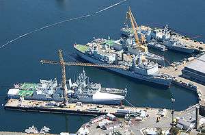
| Esquimalt Naval Sites National Historic Site of Canada |
|
Esquimalt |
V9A |
48°26′02″N 123°26′02″W / 48.434°N 123.434°W / 48.434; -123.434 (Esquimalt Naval Sites National Historic Site of Canada) |
12301 |
|
|
|
More images |
| Former Armament Artificer's and Sergeant's Quarters, Building 522 |
|
Esquimalt |
|
48°26′00″N 123°25′59″W / 48.4333°N 123.433°W / 48.4333; -123.433 (Former Armament Artificer's and Sergeant's Quarters, Building 522) |
3986 |
|
|
|
|
| Former Married Privates' Quarters, Building 523 |
|
Esquimalt |
|
48°26′00″N 123°25′59″W / 48.4333°N 123.433°W / 48.4333; -123.433 (Former Married Privates' Quarters, Building 523) |
3985 |
|
|
|
|
| Former Offices of the Officer-in-Charge |
CFB Esquimalt |
Esquimalt |
|
48°25′48″N 123°26′06″W / 48.43°N 123.435°W / 48.43; -123.435 (Former Offices of the Officer-in-Charge) |
3991 |
|
|
|
|
| Guard House Building 38 |
|
Esquimalt |
|
48°26′N 123°29′W / 48.43°N 123.48°W / 48.43; -123.48 (Guard House Building 38) |
2652 |
|
|
|
|
| Gun Emplacement, Building 578 |
Signal Hill |
Esquimalt |
|
|
4754 |
|
|
|
|
| Gunnery School, former Building 50 |
|
Esquimalt |
|
48°25′48″N 123°26′06″W / 48.43°N 123.435°W / 48.43; -123.435 (Gunnery School, former Building 50) |
3990 |
|
|
|
|
| Naden Museum Square, Building 20 |
|
Esquimalt |
|
48°26′11″N 123°25′16″W / 48.4364°N 123.421°W / 48.4364; -123.421 (Naden Museum Square, Building 20) |
10131 |
|
|
|
|
| Naden Museum Square, Building 37 |
|
Esquimalt |
|
48°26′09″N 123°25′19″W / 48.4359°N 123.422°W / 48.4359; -123.422 (Naden Museum Square, Building 37) |
10143 |
|
|
|
|
| Naden, Building Nos. 33, 33A, 33B Former Drill Hall |
|
Esquimalt |
|
48°25′48″N 123°26′06″W / 48.43°N 123.435°W / 48.43; -123.435 (Naden, Building Nos. 33, 33A, 33B) |
3989 |
|
|
|
|
| Naden, Museum Square, Building No. 35 |
|
Esquimalt |
|
48°25′48″N 123°26′06″W / 48.43°N 123.435°W / 48.43; -123.435 (Naden, Museum Square, Building No. 35) |
3913 |
|
|
|
|
| Protestant Chapel Building 39 |
|
Esquimalt |
|
48°25′48″N 123°26′06″W / 48.43°N 123.435°W / 48.43; -123.435 (Protestant Chapel Building 39) |
3914 |
|
|
|
|
| Radar Training Building |
|
Esquimalt |
|
48°26′23″N 123°24′58″W / 48.4398°N 123.416°W / 48.4398; -123.416 (Radar Training Building) |
13215 |
|
|
|
|
| Royal Garrison Artillery Barracks’ Blocks, Building 1075 |
|
Esquimalt |
|
48°25′48″N 123°26′06″W / 48.43°N 123.435°W / 48.43; -123.435 (Royal Garrison Artillery Barracks’ Blocks, Building 1075) |
2829 |
|
|
|
|
| Shipwrights' Shed / Spar Shed, Building D113 |
|
Esquimalt |
V9A |
48°25′48″N 123°26′06″W / 48.43°N 123.435°W / 48.43; -123.435 (Shipwrights' Shed / Spar Shed, Building D113) |
4477 |
|
|
|
|
| Signal Hill No. 508 |
|
Esquimalt |
|
|
3987 |
|
|
|
|
| Stores / Museum Warehouse, Building 29 |
|
Esquimalt |
|
48°25′48″N 123°26′06″W / 48.43°N 123.435°W / 48.43; -123.435 (Stores / Museum Warehouse, Building 29) |
3915 |
|
|
|
|
| Torpedo School, former Building 2 |
|
Esquimalt |
|
|
6194 |
|
|
|
|
| Trades Training Building |
|
Esquimalt |
|
48°26′23″N 123°24′58″W / 48.4398°N 123.416°W / 48.4398; -123.416 (Trades Training Building) |
13176 |
|
|
|
|
| Veterans' Cemetery Chapel |
|
Esquimalt |
|
48°26′28″N 123°24′47″W / 48.441°N 123.413°W / 48.441; -123.413 (Veterans' Cemetery Chapel) |
4366 |
|
|
|
|
| Warehouse Building D85 |
|
Esquimalt |
|
48°25′48″N 123°26′06″W / 48.43°N 123.435°W / 48.43; -123.435 (Warehouse Building D85) |
4274 |
|
|
|
|
| Work Point Barracks No. 1004 |
|
Esquimalt |
|
48°25′48″N 123°26′06″W / 48.43°N 123.435°W / 48.43; -123.435 (Work Point Barracks No. 1004) |
2796 |
|
|
|
|
| Work Point Barracks No. 1020 |
|
Esquimalt |
|
48°25′48″N 123°26′06″W / 48.43°N 123.435°W / 48.43; -123.435 (Work Point Barracks No. 1020) |
2797 |
|
|
|
|
| Building D83 Oil Stores |
|
Esquimalt |
|
48°25′48″N 123°26′06″W / 48.43°N 123.435°W / 48.43; -123.435 (Building D83) |
2794 |
|
|
|
|
| Denham Till Park and Residence |
744 Birch Road |
North Saanich |
V8L |
48°40′48″N 123°28′05″W / 48.68°N 123.468°W / 48.68; -123.468 (Denham Till Park and Residence) |
|
|
11383 |
|
|
| Glamorgan Farm |
1805 Glamorgan Road |
North Saanich |
V8L |
48°39′30″N 123°25′37″W / 48.6583°N 123.427°W / 48.6583; -123.427 (Glamorgan Farm) |
|
|
11359 |
|
|
| Holy Trinity Cemetery |
1319 Mills Road |
North Saanich |
V8L |
48°39′17″N 123°26′42″W / 48.6548°N 123.445°W / 48.6548; -123.445 (Holy Trinity Cemetery) |
|
|
11357 |
|
|
| Horth Residence |
498 Downey Road |
North Saanich |
V8L |
48°40′26″N 123°28′44″W / 48.6739°N 123.479°W / 48.6739; -123.479 (Horth Residence) |
|
|
11361 |
|
|
| Lillian Hoffar Park |
10563 McDonald Park Road |
North Saanich |
V8L |
48°40′10″N 123°24′54″W / 48.6695°N 123.415°W / 48.6695; -123.415 (Lillian Hoffar Park) |
|
|
11384 |
|
|
| Lillian Hoffar Western Red Cedar |
10563 McDonald Park Road |
North Saanich |
V8L |
48°40′12″N 123°24′58″W / 48.67°N 123.416°W / 48.67; -123.416 (Lillian Hoffar Western Red Cedar) |
|
|
11385 |
|
|
| Mary Spencer Residence |
8916 Marshall Road |
North Saanich |
V8L |
48°37′26″N 123°25′01″W / 48.624°N 123.417°W / 48.624; -123.417 (Mary Spencer Residence) |
|
|
11358 |
|
|
| Nymph Point Park |
1900 block Marina Way |
North Saanich |
V8L |
48°40′29″N 123°25′01″W / 48.6748°N 123.417°W / 48.6748; -123.417 (Nymph Point Park) |
|
|
11362 |
|
|
| R.O. Bull Memorial Park |
400-block Wain Road |
North Saanich |
V8L |
48°40′36″N 123°28′48″W / 48.6767°N 123.48°W / 48.6767; -123.48 (R.O. Bull Memorial Park) |
|
|
11387 |
|
|
| The White House |
9774 West Saanich Road |
North Saanich |
V8L |
48°38′55″N 123°27′14″W / 48.6487°N 123.454°W / 48.6487; -123.454 (The White House) |
|
|
11360 |
|
|
| Wain Park |
800-block Wain Road |
North Saanich |
V8L |
48°40′41″N 123°27′43″W / 48.678°N 123.462°W / 48.678; -123.462 (Wain Park) |
|
|
11386 |
|
|
| 1150 Monterey Avenue |
1150 Monterey Avenue |
Oak Bay |
V8S |
48°25′21″N 123°18′54″W / 48.4226°N 123.315°W / 48.4226; -123.315 (1150 Monterey Avenue) |
|
|
6769 |
|
|
| 1241 Monterey Avenue |
1241 Monterey Avenue |
Oak Bay |
V8S |
48°25′25″N 123°18′50″W / 48.4236°N 123.314°W / 48.4236; -123.314 (1241 Monterey Avenue) |
|
|
6443 |
|
|
| 151 Sunny Lane |
151 Sunny Lane |
Oak Bay |
|
48°24′45″N 123°19′12″W / 48.4124°N 123.32°W / 48.4124; -123.32 (151 Sunny Lane) |
|
|
18739 |
|
|
| 1931 Bowker Place |
1931 Bowker Place |
Oak Bay |
|
48°25′51″N 123°18′22″W / 48.4307°N 123.306°W / 48.4307; -123.306 (1931 Bowker Place) |
|
|
18738 |
|

More images |
| 210 Denison Road |
210 Denison Road |
Oak Bay |
|
48°24′43″N 123°19′23″W / 48.412°N 123.323°W / 48.412; -123.323 (210 Denison Road) |
|
|
18582 |
|
|
| 2264 Windsor Road |
2264 Windsor Road |
Oak Bay |
|
48°25′20″N 123°18′50″W / 48.4223°N 123.314°W / 48.4223; -123.314 (2264 Windsor Road) |
|
|
17842 |
|
|
| 235 Denison Road |
235 Denison Road |
Oak Bay |
|
48°24′46″N 123°19′23″W / 48.4129°N 123.323°W / 48.4129; -123.323 (235 Denison Road) |
|
|
16189 |
|
|
| 2450 Windsor Road |
2450 Windsor Road |
Oak Bay |
|
48°25′22″N 123°18′32″W / 48.4227°N 123.309°W / 48.4227; -123.309 (2450 Windsor Road) |
|
|
17843 |
|
|
| 2753 Somass Drive |
2753 Somass Drive |
Oak Bay |
|
48°25′46″N 123°18′22″W / 48.4295°N 123.306°W / 48.4295; -123.306 (2753 Somass Drive) |
|
|
17841 |
|

More images |
| 318 Newport Avenue |
318 Newport Avenue |
Oak Bay |
|
48°24′41″N 123°18′11″W / 48.4115°N 123.303°W / 48.4115; -123.303 (318 Newport Avenue) |
|
|
18282 |
|
|
| 3225 Beach Drive |
3225 Beach Drive |
Oak Bay |
|
48°26′48″N 123°17′38″W / 48.4466°N 123.294°W / 48.4466; -123.294 (3225 Beach Drive) |
|
|
16188 |
|
|
| 33 Sylvan Lane |
33 Sylvan Lane |
Oak Bay |
V8S |
48°24′49″N 123°19′19″W / 48.4135°N 123.322°W / 48.4135; -123.322 (33 Sylvan Lane) |
|
|
18396 |
|
|
| 825 Foul Bay Road |
825 Foul Bay Road |
Oak Bay |
V8S |
48°25′09″N 123°19′23″W / 48.4193°N 123.323°W / 48.4193; -123.323 (825 Foul Bay Road) |
|
|
6738 |
|
|
| 929 Island Road |
929 Island Road |
Oak Bay |
V8S |
48°25′09″N 123°18′25″W / 48.4193°N 123.307°W / 48.4193; -123.307 (929 Island Road) |
|
|
6741 |
|
|
| 941 Victoria Avenue |
941 Victoria Avenue |
Oak Bay |
|
48°25′11″N 123°19′05″W / 48.4196°N 123.318°W / 48.4196; -123.318 (941 Victoria Avenue) |
|
|
18405 |
|
|
| Balgreggan |
3000 Rutland Road |
Oak Bay |
V8R |
48°26′38″N 123°17′38″W / 48.4439°N 123.294°W / 48.4439; -123.294 (Balgreggan) |
|
|
6447 |
|
|
| Bide-A-Wee House |
1538 Beach Drive |
Oak Bay |
V8R |
48°26′N 123°19′W / 48.43°N 123.31°W / 48.43; -123.31 (Bide-A-Wee House) |
|
|
2347 |
|
|
| Bleakney House |
516 Newport Avenue |
Oak Bay |
V8S |
48°24′50″N 123°18′14″W / 48.414°N 123.304°W / 48.414; -123.304 (Bleakney House) |
|
|
6446 |
|
|
| Bowden House |
2809 Burdick Avenue |
Oak Bay |
V8R |
48°26′32″N 123°18′36″W / 48.4423°N 123.31°W / 48.4423; -123.31 (Bowden House) |
|
|
6448 |
|
|
| Bryn-Y-Mor |
380 Newport Avenue |
Oak Bay |
|
48°24′44″N 123°18′14″W / 48.4123°N 123.304°W / 48.4123; -123.304 (Bryn-Y-Mor) |
|
|
18283 |
|
|
| Castle Block |
2188 Oak Bay Avenue |
Oak Bay |
V8R |
48°25′36″N 123°18′58″W / 48.4268°N 123.316°W / 48.4268; -123.316 (Castle Block) |
|
|
6715 |
|
|
| Charlewood House |
2664 Orchard Avenue |
Oak Bay |
V8S |
48°25′21″N 123°18′14″W / 48.4226°N 123.304°W / 48.4226; -123.304 (Charlewood House) |
|
|
6618 |
|
|
| Chinese Cemetery at Harling Point National Historic Site of Canada |
Crescent Road and Penzance Street |
Oak Bay |
V8S |
48°24′24″N 123°19′23″W / 48.4066°N 123.323°W / 48.4066; -123.323 (Chinese Cemetery at Harling Point National Historic Site of Canada) |
9167 |
|
|
|

More images |
| Clark House |
1086 St. Louis Street |
Oak Bay |
V8S |
48°25′16″N 123°18′22″W / 48.421°N 123.306°W / 48.421; -123.306 (Clark House) |
|
|
10961 |
|
|
| Eastman House |
2087 Byron Street |
Oak Bay |
V8R |
48°25′40″N 123°19′12″W / 48.4278°N 123.32°W / 48.4278; -123.32 (Eastman House) |
|
|
6440 |
|
|
| Elliot House |
1255 Victoria Avenue |
Oak Bay |
V8S |
48°25′26″N 123°19′05″W / 48.424°N 123.318°W / 48.424; -123.318 (Elliot House) |
|
|
16725 |
|
|
| Gilbert House |
2090 Byron Street |
Oak Bay |
V8R |
48°25′42″N 123°19′12″W / 48.4283°N 123.32°W / 48.4283; -123.32 (Gilbert House) |
|
|
6445 |
|
|
| Glenlyon Norfolk School |
1701 Beach Drive |
Oak Bay |
V8R |
48°26′N 123°19′W / 48.43°N 123.31°W / 48.43; -123.31 (Glenlyon Norfolk School) |
|
|
2345 |
|
|
| Grayson House |
2483 Cranmore Road |
Oak Bay |
V8R |
48°25′52″N 123°18′43″W / 48.4311°N 123.312°W / 48.4311; -123.312 (Grayson House) |
|
|
6536 |
|
|
| Hambley House |
2086 Byron Street |
Oak Bay |
V8R |
48°25′42″N 123°19′12″W / 48.4283°N 123.32°W / 48.4283; -123.32 (Hambley House) |
|
|
6714 |
|
|
| Hamilton-Smith House |
2753 Cavendish Avenue |
Oak Bay |
V8R |
48°25′56″N 123°18′18″W / 48.4323°N 123.305°W / 48.4323; -123.305 (Hamilton-Smith House) |
|
|
6442 |
|
|
| Harman House |
1586 York Place |
Oak Bay |
V8R |
48°26′N 123°19′W / 48.43°N 123.31°W / 48.43; -123.31 (Harman House) |
|
|
2348 |
|
|
| Henry Burt-Smith House |
1193 Beach Drive |
Oak Bay |
V8S |
48°25′13″N 123°18′00″W / 48.4204°N 123.3°W / 48.4204; -123.3 (Henry Burt-Smith House) |
|
|
6449 |
|
|
| Hinton House |
1029 Beach Drive |
Oak Bay |
V8S |
48°25′02″N 123°17′49″W / 48.4171°N 123.297°W / 48.4171; -123.297 (Hinton House) |
|
|
11089 |
|
|
| Ince |
2021 McNeill Avenue |
Oak Bay |
|
48°25′12″N 123°19′23″W / 48.4201°N 123.323°W / 48.4201; -123.323 (Ince) |
|
|
18281 |
|
|
| James Tait House |
2435 Musgrave Street |
Oak Bay |
V8R |
48°26′14″N 123°18′29″W / 48.4371°N 123.308°W / 48.4371; -123.308 (James Tait House) |
|
|
6740 |
|
|
| Jarvis House |
1050 St. Patrick Street |
Oak Bay |
V8S |
48°25′16″N 123°18′43″W / 48.421°N 123.312°W / 48.421; -123.312 (Jarvis House) |
|
|
15691 |
|
|
| Johnston House |
1275 St. David Street |
Oak Bay |
V8S |
48°25′26″N 123°18′36″W / 48.424°N 123.31°W / 48.424; -123.31 (Johnston House) |
|
|
6687 |
|
|
| Jones House |
599 Island Road |
Oak Bay |
V8S |
48°24′52″N 123°18′25″W / 48.4144°N 123.307°W / 48.4144; -123.307 (Jones House) |
|
|
6767 |
|
|
| Kildonan |
931 Foul Bay Road |
Oak Bay |
|
48°25′18″N 123°19′19″W / 48.4216°N 123.322°W / 48.4216; -123.322 (Kildonan) |
|
|
18676 |
|
|
| Kingsmount |
305 Denison Road |
Oak Bay |
V8S |
48°24′52″N 123°19′19″W / 48.4144°N 123.322°W / 48.4144; -123.322 (Kingsmount) |
|
|
6742 |
|
|
| Kirkland |
2519 Currie Road |
Oak Bay |
V8S |
48°25′18″N 123°18′22″W / 48.4217°N 123.306°W / 48.4217; -123.306 (Kirkland) |
|
|
6771 |
|
|
| Little-Oaks |
3165 Tarn Place |
Oak Bay |
|
48°26′30″N 123°17′31″W / 48.4417°N 123.292°W / 48.4417; -123.292 (Little-Oaks) |
|
|
18408 |
|
|
| Logan Mayhew House |
3515 Beach Drive |
Oak Bay |
|
48°27′10″N 123°18′00″W / 48.4527°N 123.3°W / 48.4527; -123.3 (Logan Mayhew House) |
|
|
15697 |
|
|
| Lovatt House |
2030 Milton Street |
Oak Bay |
V8R |
|
|
|
6444 |
|
|
| Margaret Marsh House |
2493 Currie Road |
Oak Bay |
V8S |
48°25′16″N 123°18′25″W / 48.4212°N 123.307°W / 48.4212; -123.307 (Margaret Marsh House) |
|
|
6770 |
|
|
| Oak Bay United Church |
2095 Granite Street |
Oak Bay |
|
48°25′29″N 123°19′12″W / 48.4248°N 123.32°W / 48.4248; -123.32 (Oak Bay United Church) |
|
|
18286 |
|
|
| Oliver House |
953 St. Patrick Street |
Oak Bay |
V8S |
48°25′11″N 123°18′40″W / 48.4197°N 123.311°W / 48.4197; -123.311 (Oliver House) |
|
|
6689 |
|
|
| Oxford Cottage |
947 Foul Bay Road |
Oak Bay |
V8S |
48°25′24″N 123°19′16″W / 48.4233°N 123.321°W / 48.4233; -123.321 (Oxford Cottage) |
|
|
6739 |
|
|
| Robin Oak |
1265 Roslyn Road |
Oak Bay |
V8S |
48°25′26″N 123°19′01″W / 48.4238°N 123.317°W / 48.4238; -123.317 (Robin Oak) |
|
|
6505 |
|
|
| Rowland Powell House |
1684 Yale Street |
Oak Bay |
V8R |
48°25′44″N 123°19′05″W / 48.4288°N 123.318°W / 48.4288; -123.318 (Rowland Powell House) |
|
|
6713 |
|
|
| Tapley House |
2138 Central Avenue |
Oak Bay |
V8S |
48°25′01″N 123°19′08″W / 48.4169°N 123.319°W / 48.4169; -123.319 (Tapley House) |
|
|
2346 |
|
|
| Tod House |
2564 Heron Street |
Oak Bay |
V8R |
48°26′16″N 123°18′22″W / 48.4378°N 123.306°W / 48.4378; -123.306 (Tod House) |
|
|
2350 |
|
|
| Turner House |
3110 Weald Road |
Oak Bay |
V8R |
48°26′43″N 123°18′18″W / 48.4454°N 123.305°W / 48.4454; -123.305 (Turner House) |
|
|
|
|
|
| Victoria Golf Club |
1110 Beach Drive |
Oak Bay |
|
48°24′53″N 123°18′00″W / 48.4146°N 123.3°W / 48.4146; -123.3 (Victoria Golf Club) |
|
|
18284 |
|
|
| William Henry Noble House |
2224 Hampshire Terrace |
Oak Bay |
V8S |
48°25′31″N 123°18′54″W / 48.4252°N 123.315°W / 48.4252; -123.315 (William Henry Noble House) |
|
|
6716 |
|
|
| Woodlands |
1668 Hampshire Road |
Oak Bay |
V8R |
48°25′50″N 123°18′58″W / 48.4305°N 123.316°W / 48.4305; -123.316 (Woodlands) |
|
|
17444 |
|
|
| 998 Gorge Road West |
998 Gorge Road West |
Saanich |
V9A |
48°27′13″N 123°25′12″W / 48.4536°N 123.42°W / 48.4536; -123.42 (998 Gorge Road West) |
|
|
3694 |
|
|
| Army Huts, University of Victoria |
3800 Finnerty Road |
Saanich |
V8P |
48°28′06″N 123°18′40″W / 48.4683°N 123.311°W / 48.4683; -123.311 (Army Huts, University of Victoria) |
|
|
1933 |
|
|
| Brown Residence |
1210 Tattersall Drive |
Saanich |
V8P |
48°27′29″N 123°21′22″W / 48.458°N 123.356°W / 48.458; -123.356 (Brown Residence) |
|
|
11697 |
|
|
| Butchart Gardens National Historic Site of Canada |
800 Benvenuto Drive |
Central Saanich |
V8M |
48°33′49″N 123°28′08″W / 48.5636°N 123.469°W / 48.5636; -123.469 (Butchart Gardens National Historic Site of Canada) |
7821 |
|
|
|

More images |
| Captain Walker Residence |
3808 Heritage Lane |
Saanich |
V8Z |
48°27′54″N 123°24′47″W / 48.465°N 123.413°W / 48.465; -123.413 (Captain Walker Residence) |
|
|
1795 |
|
|
| Cedar Hill School |
3861 Cedar Hill Cross Road |
Saanich |
V8P |
48°27′50″N 123°20′28″W / 48.464°N 123.341°W / 48.464; -123.341 (Cedar Hill School) |
|
|
1796 |
|
|
| Cedar Hill School Manual Training Hall |
3851 Cedar Hill Cross Road |
Saanich |
V8P |
48°27′50″N 123°20′24″W / 48.4639°N 123.34°W / 48.4639; -123.34 (Cedar Hill School Manual Training Hall) |
|
|
1794 |
|
|
| Claxton Residence |
3501 Cedar Hill Road |
Saanich |
V8P |
48°27′27″N 123°20′20″W / 48.4576°N 123.339°W / 48.4576; -123.339 (Claxton Residence) |
|
|
3692 |
|
|
| Clovelly |
1196 Clovelly Terrace |
Saanich |
V8P |
48°27′22″N 123°21′23″W / 48.456°N 123.3564°W / 48.456; -123.3564 (Clovelly) |
|
|
3697 |
|
|
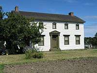
| Craigflower Schoolhouse |
2755 Admirals Road |
Saanich |
V9A |
48°27′09″N 123°25′19″W / 48.4524°N 123.422°W / 48.4524; -123.422 (Craigflower Schoolhouse) |
|
1449 |
|
|
 |
| Dodd House |
4139 Lambrick Way |
Saanich |
V8N |
48°28′41″N 123°19′34″W / 48.478°N 123.326°W / 48.478; -123.326 (Dodd House) |
|
|
1790 |
|
|
| Dominion Astrophysical Observatory |
5071 West Saanich Road |
Saanich |
|
48°31′16″N 123°25′01″W / 48.521°N 123.417°W / 48.521; -123.417 (Dominion Astrophysical Observatory) |
2966
16392 |
|
|
|

More images |
| Douglas Street Baptist Church |
3277 Douglas Street |
Saanich |
V8X |
48°26′56″N 123°22′23″W / 48.449°N 123.373°W / 48.449; -123.373 (Douglas Street Baptist Church) |
|
|
1832 |
|
|
| Duke Residence |
1140 Tattersall Drive |
Saanich |
V8P |
48°27′30″N 123°21′31″W / 48.4583°N 123.3587°W / 48.4583; -123.3587 (Duke Residence) |
|
|
1803 |
|
|
| Dunlop House |
3100 Foul Bay Road |
Saanich |
V8P |
48°26′47″N 123°19′23″W / 48.4465°N 123.323°W / 48.4465; -123.323 (Dunlop House) |
|
|
1770 |
|

More images |
| French Residence |
3301 Camrose Court |
Saanich |
V8P |
48°27′19″N 123°21′20″W / 48.45525°N 123.35543°W / 48.45525; -123.35543 (French Residence) |
|
|
1761 |
|
|
| Fullerton/McClung Residence |
1861 Ferndale Road |
Saanich |
V8N |
48°29′24″N 123°18′50″W / 48.49°N 123.314°W / 48.49; -123.314 (Fullerton/McClung Residence) |
|
|
1764 |
|
|
| Gordon Head Community Hall |
4146 Tyndall Avenue |
Saanich |
V8N |
48°28′42″N 123°19′23″W / 48.4784°N 123.323°W / 48.4784; -123.323 (Gordon Head Community Hall) |
|
|
1772 |
|
|
| Goward House |
2495 Arbutus Road |
Saanich |
V8N |
48°28′00″N 123°17′49″W / 48.4668°N 123.297°W / 48.4668; -123.297 (Goward House) |
|
|
1437 |
|
|
| Graham Residence |
452 Boleskine Road |
Saanich |
V8Z |
48°27′09″N 123°22′48″W / 48.4525°N 123.38°W / 48.4525; -123.38 (Graham Residence) |
|
|
10758 |
|
|
| Hamilton Residence |
355 Gorge Road West |
Saanich |
V9A |
48°26′53″N 123°24′11″W / 48.448°N 123.403°W / 48.448; -123.403 (Hamilton Residence) |
|
|
1822 |
|
|
| Hampton Hall |
274 Hampton Road |
Saanich |
V8Z |
48°27′17″N 123°23′31″W / 48.4547°N 123.392°W / 48.4547; -123.392 (Hampton Hall) |
|
|
1838 |
|
|
| Hamsterley Farm Water Tower |
2485 Sinclair Road |
Saanich |
V8P |
48°27′49″N 123°18′11″W / 48.4636°N 123.303°W / 48.4636; -123.303 (Hamsterley Farm Water Tower) |
|
|
1932 |
|
|
| High Oaks Farm |
4051 Granville Avenue |
Saanich |
V9E |
48°28′39″N 123°25′34″W / 48.4774°N 123.426°W / 48.4774; -123.426 (High Oaks Farm) |
|
|
1836 |
|
|
| Hill Farm |
4040 Wilkinson Road |
Saanich |
V8Z |
48°28′30″N 123°24′50″W / 48.475°N 123.414°W / 48.475; -123.414 (Hill Farm) |
|
|
3693 |
|
|
| Holland Residence |
1170 Tattersall Drive |
Saanich |
V8P |
48°27′29″N 123°21′29″W / 48.4581°N 123.358°W / 48.4581; -123.358 (Holland Residence) |
|
|
1833 |
|
|
| Home Lumber Company Office |
470 Ardersier Road |
Saanich |
V8Z |
48°27′02″N 123°22′44″W / 48.4505°N 123.379°W / 48.4505; -123.379 (Home Lumber Company Office) |
|
|
1827 |
|
|
| Horspool Residence |
321 Gorge Road |
Saanich |
V9A |
48°26′51″N 123°24′07″W / 48.4476°N 123.402°W / 48.4476; -123.402 (Horspool Residence) |
|
|
1837 |
|
|
| Hutchison Residence |
810 Rogers Avenue |
Saanich |
V8X |
48°28′41″N 123°22′41″W / 48.478°N 123.378°W / 48.478; -123.378 (Hutchison Residence) |
|
|
1821 |
|
|
| Jones Residence |
1911 Woodley Road |
Saanich |
V8P |
48°27′07″N 123°19′30″W / 48.452°N 123.325°W / 48.452; -123.325 (Jones Residence) |
|
|
1765 |
|
|
| Kitchin Residence |
3577 McInnis Rise |
Saanich |
V8P |
48°27′25″N 123°21′22″W / 48.4569°N 123.356°W / 48.4569; -123.356 (Kitchin Residence) |
|
|
1825 |
|
|
| Lake Hill Pumping Station |
3940 Quadra Street |
Saanich |
V8X |
48°27′57″N 123°21′43″W / 48.4659°N 123.362°W / 48.4659; -123.362 (Lake Hill Pumping Station) |
|
|
3695 |
|
|
| Lambrick House |
4135 Lambrick Way |
Saanich |
V8N |
48°28′43″N 123°19′41″W / 48.4786°N 123.328°W / 48.4786; -123.328 (Lambrick House) |
|
|
1767 |
|
|
| Lee Residence |
5259 Patricia Bay Highway |
Saanich |
V8Y |
48°31′44″N 123°23′10″W / 48.5288°N 123.386°W / 48.5288; -123.386 (Lee Residence) |
|
|
3696 |
|
|
| Maritime Naval Communication Centre |
2260 McCoy Road |
Saanich |
V8N |
48°28′09″N 123°18′50″W / 48.4692°N 123.314°W / 48.4692; -123.314 (Maritime Naval Communication Centre) |
|
|
1931 |
|
|
| McRae Residence |
1445 Ocean View Road |
Saanich |
V8P |
48°27′05″N 123°20′38″W / 48.4514°N 123.344°W / 48.4514; -123.344 (McRae Residence) |
|
|
1826 |
|
|
| Mercer Residence |
4366 Blenkinsop Road |
Saanich |
V8X |
48°29′19″N 123°21′25″W / 48.4886°N 123.357°W / 48.4886; -123.357 (Mercer Residence) |
|
|
3691 |
|
|
| Mount View High School |
3818 Carey Road |
Saanich |
V8Z |
48°27′32″N 123°22′55″W / 48.4589°N 123.382°W / 48.4589; -123.382 (Mount View High School) |
|
|
1762 |
|
|
| Norfolk Lodge |
5789 Brookhill Road |
Saanich |
V9E |
48°32′22″N 123°25′16″W / 48.5394°N 123.421°W / 48.5394; -123.421 (Norfolk Lodge) |
|
|
1759 |
|
|
| Old Municipal Hall |
4512 West Saanich Road |
Saanich |
V8Z |
48°29′42″N 123°23′20″W / 48.495°N 123.389°W / 48.495; -123.389 (Old Municipal Hall) |
|
|
1823 |
|
|
| Provincial Normal School |
3100 Foul Bay Road |
Saanich |
V8P |
48°26′51″N 123°19′30″W / 48.4475°N 123.325°W / 48.4475; -123.325 (Provincial Normal School) |
|
9203 |
1763 |
|

More images |
| Richmond Road Streetcar Shelter |
3100 Foul Bay Road |
Saanich |
V8P |
48°26′51″N 123°19′34″W / 48.4474°N 123.326°W / 48.4474; -123.326 (Richmond Road Streetcar Shelter) |
|
|
1930 |
|

More images |
| Rockside |
1141 Palmer Road |
Saanich |
V8P |
48°27′46″N 123°21′30″W / 48.4628°N 123.3583°W / 48.4628; -123.3583 (Rockside) |
|
|
6704 |
|
|
| Royal Oak Burial Park |
4673 Falaise Drive |
Saanich |
V8Y |
48°30′22″N 123°22′44″W / 48.506°N 123.379°W / 48.506; -123.379 (Royal Oak Burial Park) |
|
|
1843 |
|
|
| Royal Oak Community Hall |
4516 West Saanich Road |
Saanich |
V8Z |
48°29′43″N 123°23′24″W / 48.4953°N 123.39°W / 48.4953; -123.39 (Royal Oak Community Hall) |
|
|
1824 |
|
|
| Royal Oak Inn |
4509 West Saanich Road |
Saanich |
V8Z |
48°29′42″N 123°23′17″W / 48.495°N 123.388°W / 48.495; -123.388 (Royal Oak Inn) |
|
|
1807 |
|
|
| Royal Oak Schoolhouse |
4525 West Saanich Road |
Saanich |
V8Z |
48°29′46″N 123°23′20″W / 48.496°N 123.389°W / 48.496; -123.389 (Royal Oak Schoolhouse) |
|
|
1783 |
|
|
| Saanich Municipal Hall |
770 Vernon Avenue |
Saanich |
V8X |
48°27′33″N 123°22′37″W / 48.4593°N 123.377°W / 48.4593; -123.377 (Saanich Municipal Hall) |
|
|
1806 |
|
|
| Saanich War Memorial Health Centre |
4353 West Saanich Road |
Saanich |
V8Z |
48°29′19″N 123°23′10″W / 48.4885°N 123.386°W / 48.4885; -123.386 (Saanich War Memorial Health Centre) |
|
|
1804 |
|
|
| Spurgin Residence |
1908 Waterloo Road |
Saanich |
V8P |
48°27′04″N 123°19′34″W / 48.4511°N 123.326°W / 48.4511; -123.326 (Spurgin Residence) |
|
|
1768 |
|
|
| St. Luke's Anglican Church |
3801 Cedar Hill Cross Road |
Saanich |
V8P |
48°27′47″N 123°20′13″W / 48.463°N 123.337°W / 48.463; -123.337 (St. Luke's Anglican Church) |
|
|
1757 |
|
|
| St. Michael and All Angels' Church |
4733 West Saanich Road |
Saanich |
V8Z |
48°30′10″N 123°24′18″W / 48.5029°N 123.405°W / 48.5029; -123.405 (St. Michael and All Angels' Church) |
|
|
1839 |
|
|
| Stevens Hotel |
4794 West Saanich Road |
Saanich |
V8Z |
48°30′16″N 123°24′29″W / 48.5045°N 123.408°W / 48.5045; -123.408 (Stevens Hotel) |
|
|
1841 |
|
|
| Stranton Lodge |
1248 Burnside Road West |
Saanich |
V8Z |
48°28′05″N 123°25′08″W / 48.468°N 123.419°W / 48.468; -123.419 (Stranton Lodge) |
|
|
1792 |
|
|
| Strawberry Vale Schoolhouse |
1351 Hastings Street |
Saanich |
V8Z |
48°28′44″N 123°25′05″W / 48.4789°N 123.418°W / 48.4789; -123.418 (Strawberry Vale Schoolhouse) |
|
|
1782 |
|
|
| Swan Lake and Brett Trestles |
NE of Saanich Road |
Saanich |
V8X |
48°27′54″N 123°21′58″W / 48.4649°N 123.366°W / 48.4649; -123.366 (Swan Lake and Brett Trestles) |
|
|
1805 |
|
|
| The University School |
3400 Richmond Road |
Saanich |
V8P |
48°27′06″N 123°19′41″W / 48.4517°N 123.328°W / 48.4517; -123.328 (The University School) |
|
|
1771 |
|
|
| Thompson Farm |
5271 Old West Saanich Road |
Saanich |
V9E |
48°31′25″N 123°24′36″W / 48.5237°N 123.41°W / 48.5237; -123.41 (Thompson Farm) |
|
|
1842 |
|
|
| Thrums |
1775 Barrie Road |
Saanich |
V8N |
48°29′27″N 123°19′08″W / 48.4909°N 123.319°W / 48.4909; -123.319 (Thrums) |
|
|
1438 |
|
|
| Tillicum School |
3155 Albina Street |
Saanich |
V9A |
48°27′10″N 123°23′31″W / 48.4529°N 123.392°W / 48.4529; -123.392 (Tillicum School) |
|
|
1834 |
|
|
| Tolmie School |
556 Boleskin Road |
Saanich |
V8Z |
48°27′11″N 123°22′41″W / 48.4531°N 123.378°W / 48.4531; -123.378 (Tolmie School) |
|
|
1756 |
|
|
| Trend House |
3516 Richmond Road |
Saanich |
V8P |
48°27′14″N 123°19′37″W / 48.4538°N 123.327°W / 48.4538; -123.327 (Trend House) |
|
|
1769 |
|
|
| Watson House |
751 Burke Street |
Saanich |
V9A |
48°27′30″N 123°24′25″W / 48.4582°N 123.407°W / 48.4582; -123.407 (Watson House) |
|
|
11656 |
|
|
| Wayne Residence |
1268 Tattersall Drive |
Saanich |
V8P |
48°27′33″N 123°21′05″W / 48.4593°N 123.3514°W / 48.4593; -123.3514 (Wayne Residence) |
|
|
1828 |
|
|
| Westward Ho |
3930 Telegraph Bay Road |
Saanich |
V8N |
48°27′36″N 123°17′17″W / 48.4599°N 123.288°W / 48.4599; -123.288 (Westward Ho) |
|
|
3686 |
|
|
| Wilkinson Road Jail |
4216 Wilkinson Road |
Saanich |
V8Z |
48°28′59″N 123°24′36″W / 48.483°N 123.41°W / 48.483; -123.41 (Wilkinson Road Jail) |
|
|
1793 |
|
|
| Wilkinson Road Methodist Church |
4274 Wilkinson Road |
Saanich |
V8Z |
48°29′07″N 123°24′22″W / 48.4854°N 123.406°W / 48.4854; -123.406 (Wilkinson Road Methodist Church) |
|
|
1835 |
|
|
| Saanichton Centre for Plant Health, Building 28 |
8801 East Saanich Road |
North Saanich |
V8L |
48°37′16″N 123°24′58″W / 48.621°N 123.416°W / 48.621; -123.416 (Saanichton Centre for Plant Health, Building 28) |
16526 |
|
|
|
|
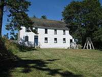
| Craigflower Manor |
110 Island Highway |
View Royal |
V9B |
48°27′07″N 123°25′30″W / 48.452°N 123.425°W / 48.452; -123.425 (Craigflower Manor) |
|
1450 |
|
|
 |