List of foreshocks and aftershocks of the 2011 Tōhoku earthquake
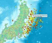
Map of aftershocks until March 14 (first 4 days)
Visualization of intensity of aftershocks in the first few days
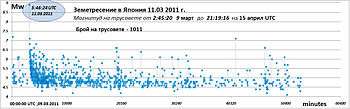
This is a list of foreshocks and aftershocks of the 2011 Tōhoku earthquake. Japan had experienced 900 aftershocks after the M9.0 earthquake on March 11, 2011 with about 60 aftershocks being over magnitude 6.0 and three over magnitude 7.0. For conciseness, only earthquakes with magnitudes greater than 7.0 or an intensity greater than lower-6 on the shindo scale are listed here. Mw refers to the moment magnitude scale, while Mjma, Mjma, or Mj refer to the Japan Meteorological Agency intensity scale.
Foreshock
| Japan Time | Magnitude | Latitude | Longitude | Depth | Intensity (shindo)[1] | Comment |
|---|---|---|---|---|---|---|
| 2011-03-09 11:45 | Mw 7.3, Mj 7.3[2] | 38.424°N | 142.836°E | 32 km[USGS 1] | lower 5 | The source was estimated to have a length of 28.7 km and a width of 53.2 km with a slip of 1.25 m.[3] |
Main shock
| Japan Time | Magnitude | Latitude | Longitude | Depth | Intensity (shindo)[1] | Comment |
|---|---|---|---|---|---|---|
| 2011-03-11 14:46 | Mw 9.0, Mj 8.4[2] | 38.322°N | 142.369°E | 29 km[USGS 2] | 7 | Further information: 2011 Tōhoku earthquake and tsunami 15,873 dead, 2,768 missing as of November 7, 2012,[4] tsunami, nuclear incidents. |
Aftershocks
| Japan Time | Magnitude | Latitude | Longitude | Depth | Intensity (shindo)[1] | Comment |
|---|---|---|---|---|---|---|
| 2011-03-11 15:08 | Mj 7.4[1] | 39.82°N | 139.025°E | 32 km[1] | lower 5 | |
| 2011-03-11 15:15 | Mw 7.9, Mj 7.6[1] | 36.27°N | 141.14°E | 43 km[USGS 3] | upper 6 | |
| 2011-03-11 15:25 | Mw 7.7, Mj 7.5[1] | 38.05°N | 144.59°E | 19 km[USGS 4] | 4 | |
| 2011-04-07 23:32 | Mw 7.1, Mj 7.2[1] | 38.253°N | 141.640°E | 42 km[USGS 5] | upper 6 | Further information: April 2011 Miyagi earthquake 4 dead, 100+ injured, large scale power outage in Tōhoku region.[5][6] |
| 2011-04-11 17:16 | Mw 6.6, Mj 7.0[1] | 37.007°N | 140.477°E | 10 km[USGS 6] | lower 6 | Further information: April 2011 Fukushima earthquake 6 dead, several injured, localized power outage and landslides in Iwaki, Fukushima.[7] |
| 2011-04-12 14:07 | Mj 6.4[1] | 37.052°N | 140.643°E | 15 km[1] | lower 6 | |
| 2011-07-10 09:57 | Mw 7.0, Mj 7.3[1] | 38.040°N | 143.287°E | 23 km[USGS 7] | 4 | 10 cm of tsunami in Sōma and Ōfunato.[8] |
| 2012-12-07 17:18 | Mw 7.3[1] | 37.8°N | 144.2°E | 49 km (JMA)[1] 36 km [USGS 8] |
lower 5 | Further information: 2012 Kamaishi earthquake Tsunami under 1 meter. Considered an aftershock by the National Earthquake Information Center in Colorado, USA.[9] |
| 2013-10-26 02:10 | Mw 7.1 | 37.170°N | 144.665°E | 10 km [USGS 9] | 4 | Tsunami[10] |
Possibly related earthquakes
The following earthquakes are possibly related to the 2011 Tōhoku earthquake. However, agreement toward the relationships has not been reached among the researchers.[11]
| Japan Time | Magnitude | Latitude | Longitude | Depth | Intensity (shindo)[1] | Comment |
|---|---|---|---|---|---|---|
| 2011-03-12 03:59 | Mw 6.3, Mj 6.7[1] | 37.02° N | 138.36°E | 8 km[1] 2 km[USGS 10] |
upper 6 | Possibly a triggered earthquake.[12][13] |
| 2011-03-12 04:31 | Mj 5.9[1] | 36.948° N | 138.572°E | 1 km[1] | lower 6 | Possibly a triggered earthquake.[13] |
| 2011-03-12 05:42 | Mj 6.3[1] | 36.972° N | 138.59°E | 2 km[1] | lower 6 | Possibly a triggered earthquake.[13] |
| 2011-03-15 22:31 | Mw 6.0, Mj 6.4[2] | 35.29°N | 138.54°E | 9 km[USGS 11] | upper 6 | 50 injured. Power outage.[14] Near presumed location of magma chamber of Mount Fuji. Sinistral strike-slip fault.[15] Possibly a triggered earthquake.[16] |
References
USGS
- ↑ Magnitude 7.2 – NEAR THE EAST COAST OF HONSHU, JAPAN. Earthquake.usgs.gov. Retrieved on 2011-04-12.
- ↑ Magnitude 9.0 – NEAR THE EAST COAST OF HONSHU, JAPAN. Earthquake.usgs.gov (2011-03-14). Retrieved on 2011-04-12.
- ↑ : Preliminary Earthquake Report: NEAR THE EAST COAST OF HONSHU, JAPAN, USGS Earthquake Hazards Program (2011-03-11). Retrieved on 2011-04-12.
- ↑ USGS Earthquake Hazards Program: Preliminary Earthquake Report: OFF THE EAST COAST OF HONSHU, JAPAN. Neic.usgs.gov (2011-03-11). Retrieved on 2011-04-12.
- ↑ Magnitude 7.1 – NEAR THE EAST COAST OF HONSHU, JAPAN. Earthquake.usgs.gov. Retrieved on 2011-04-12.
- ↑ Magnitude 6.6 – EASTERN HONSHU, JAPAN. Earthquake.usgs.gov. Retrieved on 2011-04-12.
- ↑ http://earthquake.usgs.gov/earthquakes/recenteqsww/Quakes/usc0004sg6.php
- ↑ http://earthquake.usgs.gov/earthquakes/eventpage/usc000e5n4#summary
- ↑ http://earthquake.usgs.gov/earthquakes/eventpage/usc000kn4n
- ↑ USGS Earthquake Hazards Program: Preliminary Earthquake Report: NEAR THE WEST COAST OF HONSHU, JAPAN. Neic.usgs.gov. Retrieved on 2011-04-12.
- ↑ USGS Earthquake Hazards Program: Preliminary Earthquake Report: EASTERN HONSHU, JAPAN. Neic.usgs.gov (2011-03-15). Retrieved on 2011-04-12.
Other
- 1 2 3 4 5 6 7 8 9 10 11 12 13 14 15 16 17 18 19 20 21 震度データベース検索. Japan Meteorological Agency. Retrieved on 2013-02-18.
- 1 2 3 「平成23 年(2011 年)東北地方太平洋沖地震」について(第28 報)(Press Release), 25 March 2011. Published by Japan Meteorological Agency.
- ↑ http://www.aob.geophys.tohoku.ac.jp/info/topics/20110311_news/
- ↑ http://www.asahi.com/national/update/1107/TKY201211070944.html
- ↑ asahi.com(朝日新聞社):東北の広域停電、完全復旧めどたたず 余震死者2人 – 東日本大震災. Asahi.com (2011-04-08). Retrieved on 2011-04-12.
- ↑ 7日の地震 4人死亡141人けが NHKニュース. .nhk.or.jp. Retrieved on 2011-04-12.
- ↑ CNN Wire Staff (11 April 2011). "At least 6 killed in new Japan earthquake". articles.cnn.com. CNN World News. Retrieved 2011-04-23.
- ↑ http://www.asahi.com/national/update/0710/TKY201107100080.html
- ↑ Japanese Quake Stirs On-Air Alarm, but No Damage to Nuclear Plants Is Reported, New York Times
- ↑ http://www.asahi.com/articles/TKY201310260033.html?ref=com_top6
- ↑ 静岡東部の震度6強、東海地震誘発せず…専門家 : 科学 : YOMIURI ONLINE(読売新聞). Yomiuri.co.jp. Retrieved on 2011-04-12.
- ↑ 2011年3月 東北地方太平洋沖地震 | 広報アウトリーチ室. Outreach.eri.u-tokyo.ac.jp. Retrieved on 2011-04-12.
- 1 2 3 「平成23年(2011年)東北地方太平洋沖地震」について(第38報)(Press Release), 12 April 2011. Published by Japan Meteorological Agency. Retrieved on 2013-02-17.
- ↑ http://www.pref.shizuoka.jp/kinkyu/documents/0315toubujisin5.pdf
- ↑ 2011年3月15日静岡県東部の地震の評価. Jishin.go.jp. Retrieved on 2011-04-17.
- ↑ 東日本沖巨大地震. Sk01.ed.shizuoka.ac.jp. Retrieved on 2011-04-12.
External links
| Geology | |||||||||||||
|---|---|---|---|---|---|---|---|---|---|---|---|---|---|
| Affected areas | |||||||||||||
| Affected infrastructure | |||||||||||||
| Nuclear accidents | |||||||||||||
| Aftershocks |
| ||||||||||||
| People | |||||||||||||
| Fundraisers | |||||||||||||
| Other | |||||||||||||
This article is issued from Wikipedia - version of the 11/15/2016. The text is available under the Creative Commons Attribution/Share Alike but additional terms may apply for the media files.