List of extant pinfolds in Cheshire
Capenhurst pinfold
A pinfold was a structure into which straying animals were placed until they were retrieved by their owner on payment of a fine. Other terms for the structure were penfold or pound. These names were derived from the Old English words pund (pound) and fuld (fold).[1] In Cheshire, most of these were square or circular stone structures, although there is a circular pinfold in Henbury.[2] There is evidence of the existence of at least 153 pinfolds in Cheshire,[3] although as of 2010 only eight of these remain in the current county of Cheshire.[4] There are also the remains of four other pinfolds in the county.[5]
Key
| Grade | Criteria[6] |
|---|---|
| II | Buildings of national importance and special interest |
| Location | Map ref and coordinates | Photograph | Dimensions | Notes | Grading |
|---|---|---|---|---|---|
| Capenhurst | SJ366737 53°15′26″N 2°57′06″W / 53.25722°N 2.95159°W |
 |
Approximately 6 metres (19 ft 8 in) square. Walls 1.4 metres (4 ft 7 in) high |
Coursed sandstone walls with capstones | II[7] |
| Great Budworth | SJ686792 53°18′33″N 2°28′20″W / 53.30926°N 2.47210°W |
 |
Approximately 10 metres (32 ft 10 in) square. Walls 1.4 metres (4 ft 7 in) high |
Coursed sandstone walls with capstones | II[8] |
| Harthill | SJ500552 53°05′32″N 2°44′50″W / 53.09218°N 2.74719°W |
Probably: front and back walls 6 metres (19 ft 8 in), side walls 3 metres (9 ft 10 in), height 2 metres (6 ft 7 in) |
Roof and additional walling added. Now used as a storage shed. |
— | |
| Henbury | SJ862727 53°15′05″N 2°12′26″W / 53.25135°N 2.20729°W |
Circular, approximately 4.5 metres (14 ft 9 in) diameter walls approximately 1.2 metres (3 ft 11 in) high |
Roughly coursed sandstone rubble with flat cement coping | II[9] | |
| Hoole Village | SJ433687 53°12′46″N 2°51′02″W / 53.21280°N 2.85058°W |
 |
5 metres (16 ft 5 in) square height 1.8 metres (5 ft 11 in) |
Coursed sandstone | II[10] |
| Little Budworth | SJ593654 53°11′05″N 2°36′37″W / 53.18464°N 2.61019°W |
6.5 metres (21 ft 4 in) square height 1.6 metres (5 ft 3 in) |
Coursed sandstone walls with capstones | II[11] | |
| Sutton Lane Ends | SJ927716 53°14′30″N 2°06′37″W / 53.24166°N 2.11016°W |
Front wall 7.7 metres (25 ft 3 in) height 1.85 metres (6 ft 1 in); back wall 7.7 metres (25 ft 3 in) height 1 metre (3 ft 3 in); side walls 6 metres (19 ft 8 in) height 1 metre (3 ft 3 in) |
Coursed sandstone walls with capstones. | ? | |
| Wardle | SJ609572 53°06′39″N 2°35′03″W / 53.11084°N 2.58418°W |
4.2 metres (13 ft 9 in) square height 1.2 metres (3 ft 11 in) |
Coursed sandstone walls with capstones. | II[12] | |
| Location | Map ref and coordinates | Photograph | Dimensions | Notes | Grading |
|---|---|---|---|---|---|
| Bickerton | SJ515538 53°04′48″N 2°43′31″W / 53.07997°N 2.72518°W |
Originally approximately: front and back walls 6 metres (19 ft 8 in), side walls 4 metres (13 ft 1 in), height 1.5 metres (4 ft 11 in) |
Remains of sandstone side walls up to 1.5 metres (4 ft 11 in) in places. Little remains of back wall; front wall gone. | — | |
| Poole | SJ639554 53°05′43″N 2°32′24″W / 53.09520°N 2.54007°W |
 |
Formerly 3 metres (9 ft 10 in) square. Walls 1 metre (3 ft 3 in) high |
Built in red sandstone rubble, now partly demolished. | II[13] |
| Shocklach | SJ438492 53°02′15″N 2°50′18″W / 53.03759°N 2.83829°W |
A restored enclosure: front and back walls 5.2 metres (17 ft 1 in), side walls 3.6 metres (11 ft 10 in), height 1 metre (3 ft 3 in) |
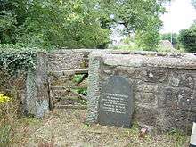
Post and rail ences at the back and sides; front open to the road. Contains the Shocklach Millennium Cross | — | |
| Tarvin | SJ491669 53°11′50″N 2°45′46″W / 53.19725°N 2.76288°W |
As of 2010 undergoing excavation | — | ||
References
- ↑ Hayns 2010, p. 27.
- ↑ Hayns 2010, pp. 28–29.
- ↑ Hayns 2010, pp. 44–45.
- 1 2 Hayns 2010, pp. 46–47.
- 1 2 Hayns 2010, p. 47.
- ↑ Listed Buildings, Historic England, retrieved 29 March 2015
- ↑ Historic England, "The Old Pinfold, Capenhurst (1115741)", National Heritage List for England, retrieved 29 March 2015
- ↑ Historic England, "The Pinfold, Aston by Budworth (1139510)", National Heritage List for England, retrieved 29 March 2015
- ↑ Historic England, "Pinfold opposite Henbury Smithy, Henbury (1139297)", National Heritage List for England, retrieved 29 March 2015
- ↑ Historic England, "Pinfold, Hoole Village (1229371)", National Heritage List for England, retrieved 29 March 2015
- ↑ Historic England, "Pinfold, Little Budworth (1139199)", National Heritage List for England, retrieved 29 March 2015
- ↑ Historic England, "Wardle Pinfold (1138609)", National Heritage List for England, retrieved 29 March 2015
- ↑ Historic England, "Pinfold 150 yards northwest of Poole Bank, Poole (1136498)", National Heritage List for England, retrieved 29 March 2015
- Bibliography
External links
![]() Media related to Pinfolds in Cheshire at Wikimedia Commons
Media related to Pinfolds in Cheshire at Wikimedia Commons
This article is issued from Wikipedia - version of the 3/29/2015. The text is available under the Creative Commons Attribution/Share Alike but additional terms may apply for the media files.